
Station YJ LEME - Lemen High School
Network: YJ01 - Ethiopia-Afar Geoscientific Lithospheric Experiment
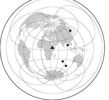
Nearby stations (2 deg radius)
| Station | Name | (Lat, Lon) | Start / End | Elevation |
| LEME | Lemen High School | (8.61, 38.61) | 2001-11-23 / 2002-10-19 | 2108 m |
| Crust2 Type: | G9,thin custal Archean 0.1 km seds., South American |
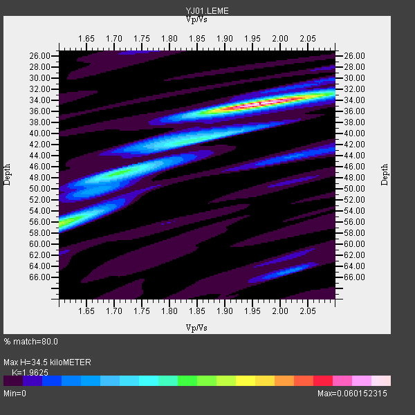
| Thickness Estimate: | 34 km |
| Thickness StdDev: | 7.1 km |
| Vp/Vs Estimate: | 1.96 |
| Vp/Vs StdDev: | 0.13 |
| Vs Estimate: | 3.294 km/s |
| Poisson's Ratio: | 0.32 |
| Peak Value: | 0.06 |
| Assumed Vp: | 6.464 km/s |
| Ps Weight: | 0.33333334 |
| PpPs Weight: | 0.33333334 |
| PsPs Weight: | 0.33333328 |
| Residual Complexity: | 0.507 |
| Nearby stations H: | +- |
| (2.0 deg) Vp/Vs: | +- |
0 with match > 90% ( 0.0 %) and 4 with match > 80% ( 100.0 %) out of 4.
Download stack as xyz text file.
Azimuth Distribution of Events:
Prior Results for this Station
| Study | Thickness | Vp/Vs | Vp | Vs | Poissons Ratio | Extra |
| EARS | 34 km | 1.96 | 6.464 km/s | 3.294 km/s | 0.32 | |
| Crust2.0 | 31 km | 1.76 | 6.464 km/s | 3.663 km/s | 0.26 | G9,thin custal Archean 0.1 km seds., South American |
| Global Maxima | 34 km | 1.96 | 6.464 km/s | 3.294 km/s | 0.32 | amp=0.060152315 |
| Local Maxima 1 | 56 km | 1.62 | 6.464 km/s | 4.002 km/s | 0.19 | amp=0.028645406 |
| Local Maxima 2 | 47 km | 1.71 | 6.464 km/s | 3.785 km/s | 0.24 | amp=0.025842208 |
| Local Maxima 3 | 40 km | 1.88 | 6.464 km/s | 3.443 km/s | 0.30 | amp=0.0152813755 |
| Local Maxima 4 | 65 km | 2.02 | 6.464 km/s | 3.204 km/s | 0.34 | amp=0.010671291 |
| Predicted Arrivals for vertical incidence (zero ray parameter) | |
| Ps | 5.14 SECOND |
| PpPs | 15.81 SECOND |
| PsPs/PpSs | 20.95 SECOND |
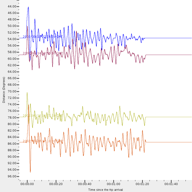
Events Processed for this Station
Download zip of receiver functions as SAC
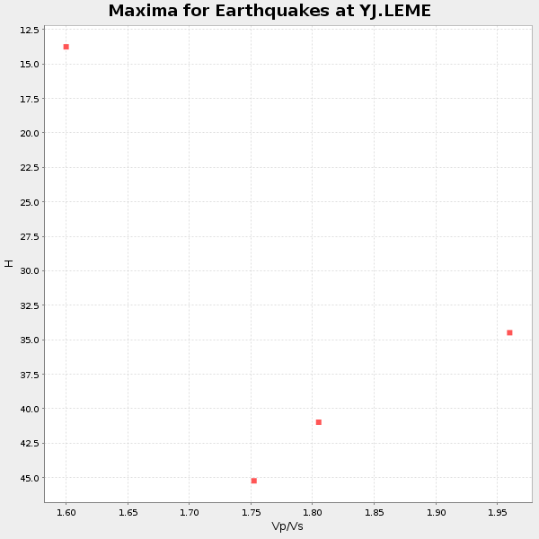
Plot maxima for each earthquake.
Events Used in the Stack
(4 events)| Radial Match | Distance | Baz | FERegion | Time | Lat/Lon | Depth | Magnitude |
| 87.73989 | 58.7 deg | 142.415 deg | Mid-Indian Ridge | 2002/05/14 16:56:10 GMT | (-36.5, 78.9) | 10 km | 5.6 MB, 6.1 MS, 6.3 MW, 6.1 MW |
| 87.61328 | 53.6 deg | 80.172 deg | Andaman Islands, India Region | 2002/09/13 22:28:29 GMT | (13.0, 93.1) | 21 km | 6.2 MB, 6.7 MS, 6.5 MW, 6.5 MW |
| 84.94944 | 85.6 deg | 46.58 deg | E. Russia-N.E. China Border Reg. | 2002/06/28 17:19:30 GMT | (43.8, 130.7) | 566 km | 6.7 MB, 7.3 MW, 7.3 MW |
| 81.29447 | 77.8 deg | 142.83 deg | Southeast Indian Ridge | 2002/06/13 01:27:19 GMT | (-47.8, 99.8) | 10 km | 5.5 MB, 6.6 MS, 6.6 MW, 6.5 MW |
Losers
(0 events)| Radial Match | Distance | Baz | FERegion | Time | Lat/Lon | Depth | Magnitude | Reason |
