You are here: Home > Network List > YJ01 - Ethiopia-Afar Geoscientific Lithospheric Experiment Stations List
> Station MECE Mechara High School > Earthquake Result Viewer
MECE Mechara High School - Earthquake Result Viewer
| Earthquake location: |
Minahassa Peninsula, Sulawesi |
| Earthquake latitude/longitude: |
-0.0/122.9 |
| Earthquake time(UTC): |
2001/12/09 (343) 18:15:02 GMT |
| Earthquake Depth: |
156 km |
| Earthquake Magnitude: |
5.7 MB, 6.2 MW, 6.0 MW |
| Earthquake Catalog/Contributor: |
WHDF/NEIC |
|
| Network: |
YJ Ethiopia-Afar Geoscientific Lithospheric Experiment |
| Station: |
MECE Mechara High School |
| Lat/Lon: |
8.59 N/40.32 E |
| Elevation: |
1775 m |
|
| Distance: |
82.6 deg |
| Az: |
278.609 deg |
| Baz: |
91.115 deg |
| Ray Param: |
0.046390984 |
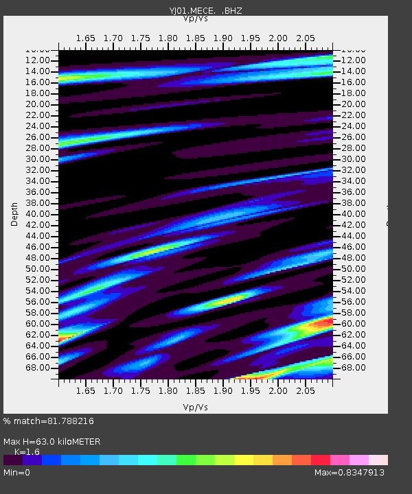
| Estimated Moho Depth: |
63.0 km |
| Estimated Crust Vp/Vs: |
1.60 |
| Assumed Crust Vp: |
6.643 km/s |
| Estimated Crust Vs: |
4.152 km/s |
| Estimated Crust Poisson's Ratio: |
0.18 |
|
| Radial Match: |
81.788216 % |
| Radial Bump: |
400 |
| Transverse Match: |
69.21228 % |
| Transverse Bump: |
400 |
| SOD ConfigId: |
20082 |
| Insert Time: |
2010-03-09 00:43:41.309 +0000 |
| GWidth: |
2.5 |
| Max Bumps: |
400 |
| Tol: |
0.001 |
|

Signal To Noise
| Channel | StoN | STA | LTA |
| YJ:MECE: :BHZ:20011209T18:26:37.25802Z | 1.6791373 | 1.0522946E-7 | 6.266876E-8 |
| YJ:MECE: :BHN:20011209T18:26:37.25802Z | 1.0955669 | 6.9654895E-8 | 6.357886E-8 |
| YJ:MECE: :BHE:20011209T18:26:37.25802Z | 2.7300913 | 1.7857856E-7 | 6.54112E-8 |
| Arrivals |
| Ps | 5.9 SECOND |
| PpPs | 24 SECOND |
| PsPs/PpSs | 30 SECOND |


