
Station YJ MECE - Mechara High School
Network: YJ01 - Ethiopia-Afar Geoscientific Lithospheric Experiment
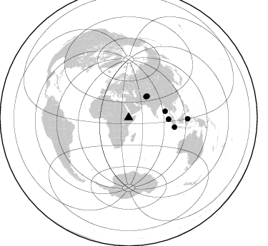
Nearby stations (2 deg radius)

| Station | Name | (Lat, Lon) | Start / End | Elevation |
| MECE | Mechara High School | (8.59, 40.32) | 2001-11-13 / 2003-01-24 | 1775 m |
| Crust2 Type: | IG,very thin late Proter., no seds. |
| Thickness Estimate: | 46 km |
| Thickness StdDev: | 9.5 km |
| Vp/Vs Estimate: | 1.73 |
| Vp/Vs StdDev: | 0.13 |
| Vs Estimate: | 3.846 km/s |
| Poisson's Ratio: | 0.25 |
| Peak Value: | 0.02 |
| Assumed Vp: | 6.643 km/s |
| Ps Weight: | 0.33333334 |
| PpPs Weight: | 0.33333334 |
| PsPs Weight: | 0.33333328 |
| Residual Complexity: | 0.743 |
| Nearby stations H: | +- |
| (2.0 deg) Vp/Vs: | +- |
4 with match > 90% ( 44.444443 %) and 8 with match > 80% ( 88.888885 %) out of 9.
Download stack as xyz text file.
Azimuth Distribution of Events:
Prior Results for this Station
| Study | Thickness | Vp/Vs | Vp | Vs | Poissons Ratio | Extra |
| EARS | 46 km | 1.73 | 6.643 km/s | 3.846 km/s | 0.25 | |
| Crust2.0 | 23 km | 1.77 | 6.643 km/s | 3.757 km/s | 0.26 | IG,very thin late Proter., no seds. |
| Global Maxima | 46 km | 1.73 | 6.643 km/s | 3.846 km/s | 0.25 | amp=0.024879232 |
| Local Maxima 1 | 33 km | 2.01 | 6.643 km/s | 3.305 km/s | 0.34 | amp=0.021223702 |
| Local Maxima 2 | 69 km | 1.95 | 6.643 km/s | 3.411 km/s | 0.32 | amp=0.01229064 |
| Local Maxima 3 | 30 km | 1.60 | 6.643 km/s | 4.152 km/s | 0.18 | amp=0.010101915 |
| Local Maxima 4 | 34 km | 1.90 | 6.643 km/s | 3.501 km/s | 0.31 | amp=0.008692125 |
| Predicted Arrivals for vertical incidence (zero ray parameter) | |
| Ps | 5.04 SECOND |
| PpPs | 18.89 SECOND |
| PsPs/PpSs | 23.92 SECOND |
Events Processed for this Station
Download zip of receiver functions as SAC
Plot maxima for each earthquake.
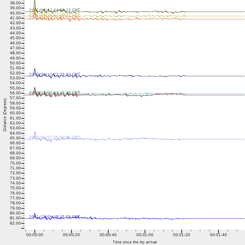
Events Used in the Stack
(8 events)| Radial Match | Distance | Baz | FERegion | Time | Lat/Lon | Depth | Magnitude |
| 95.27481 | 51.9 deg | 80.194 deg | Andaman Islands, India Region | 2002/09/13 22:28:29 GMT | (13.0, 93.1) | 21 km | 6.2 MB, 6.7 MS, 6.5 MW, 6.5 MW |
| 93.66807 | 55.7 deg | 92.429 deg | Northern Sumatra, Indonesia | 2002/11/02 01:26:10 GMT | (2.8, 96.1) | 30 km | 6.2 MB, 7.6 MS, 7.4 MW, 7.4 MW |
| 92.75832 | 65.5 deg | 101.668 deg | Sunda Strait, Indonesia | 2002/06/27 05:50:35 GMT | (-7.0, 104.2) | 11 km | 6.0 MB, 6.9 MS, 6.6 MW, 6.5 MW |
| 92.56264 | 38.0 deg | 39.834 deg | Hindu Kush Region, Afghanistan | 2002/04/12 04:00:23 GMT | (36.0, 69.4) | 10 km | 5.8 MB, 5.9 MS, 5.9 MW, 5.7 MW |
| 86.04178 | 39.6 deg | 40.934 deg | Afghanistan-Tajikistan Bord Reg. | 2001/11/23 20:43:03 GMT | (36.4, 71.5) | 106 km | 5.9 MB, 6.1 MW, 6.0 MW |
| 84.48001 | 56.0 deg | 92.221 deg | Northern Sumatra, Indonesia | 2002/11/02 09:46:46 GMT | (3.0, 96.4) | 27 km | 5.9 MB, 6.4 MS, 6.4 MW, 6.1 MW |
| 83.843 | 39.0 deg | 40.064 deg | Hindu Kush Region, Afghanistan | 2002/03/03 12:08:07 GMT | (36.4, 70.4) | 209 km | 6.3 MB |
| 81.788216 | 82.6 deg | 91.115 deg | Minahassa Peninsula, Sulawesi | 2001/12/09 18:15:02 GMT | (-0.0, 122.9) | 156 km | 5.7 MB, 6.2 MW, 6.0 MW |
Losers
(1 events)| Radial Match | Distance | Baz | FERegion | Time | Lat/Lon | Depth | Magnitude | Reason |
| 71.373886 | 94.1 deg | 91.073 deg | Irian Jaya Region, Indonesia | 2002/09/20 15:43:35 GMT | (-1.7, 134.2) | 10 km | 5.9 MB, 6.4 MS, 6.4 MW, 6.3 MW |
