You are here: Home > Network List > YJ01 - Ethiopia-Afar Geoscientific Lithospheric Experiment Stations List
> Station MECE Mechara High School > Earthquake Result Viewer
MECE Mechara High School - Earthquake Result Viewer
| Earthquake location: |
Afghanistan-Tajikistan Bord Reg. |
| Earthquake latitude/longitude: |
36.4/71.5 |
| Earthquake time(UTC): |
2001/11/23 (327) 20:43:03 GMT |
| Earthquake Depth: |
106 km |
| Earthquake Magnitude: |
5.9 MB, 6.1 MW, 6.0 MW |
| Earthquake Catalog/Contributor: |
WHDF/NEIC |
|
| Network: |
YJ Ethiopia-Afar Geoscientific Lithospheric Experiment |
| Station: |
MECE Mechara High School |
| Lat/Lon: |
8.59 N/40.32 E |
| Elevation: |
1775 m |
|
| Distance: |
39.6 deg |
| Az: |
233.419 deg |
| Baz: |
40.934 deg |
| Ray Param: |
0.07451448 |
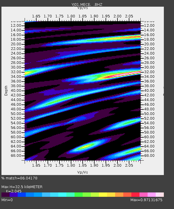
| Estimated Moho Depth: |
32.5 km |
| Estimated Crust Vp/Vs: |
2.05 |
| Assumed Crust Vp: |
6.643 km/s |
| Estimated Crust Vs: |
3.249 km/s |
| Estimated Crust Poisson's Ratio: |
0.34 |
|
| Radial Match: |
86.04178 % |
| Radial Bump: |
400 |
| Transverse Match: |
66.360405 % |
| Transverse Bump: |
400 |
| SOD ConfigId: |
20082 |
| Insert Time: |
2010-03-09 00:43:42.700 +0000 |
| GWidth: |
2.5 |
| Max Bumps: |
400 |
| Tol: |
0.001 |
|

Signal To Noise
| Channel | StoN | STA | LTA |
| YJ:MECE: :BHZ:20011123T20:49:54.300Z | 2.7245996 | 2.1207786E-7 | 7.783818E-8 |
| YJ:MECE: :BHN:20011123T20:49:54.300Z | 2.5201766 | 1.9427559E-7 | 7.708808E-8 |
| YJ:MECE: :BHE:20011123T20:49:54.300Z | 6.076673 | 4.8875484E-7 | 8.043131E-8 |
| Arrivals |
| Ps | 5.5 SECOND |
| PpPs | 14 SECOND |
| PsPs/PpSs | 19 SECOND |


