You are here: Home > Network List > YJ01 - Ethiopia-Afar Geoscientific Lithospheric Experiment Stations List
> Station MECE Mechara High School > Earthquake Result Viewer
MECE Mechara High School - Earthquake Result Viewer
| Earthquake location: |
Hindu Kush Region, Afghanistan |
| Earthquake latitude/longitude: |
36.4/70.4 |
| Earthquake time(UTC): |
2002/03/03 (062) 12:08:07 GMT |
| Earthquake Depth: |
209 km |
| Earthquake Magnitude: |
6.3 MB |
| Earthquake Catalog/Contributor: |
WHDF/NEIC |
|
| Network: |
YJ Ethiopia-Afar Geoscientific Lithospheric Experiment |
| Station: |
MECE Mechara High School |
| Lat/Lon: |
8.59 N/40.32 E |
| Elevation: |
1775 m |
|
| Distance: |
39.0 deg |
| Az: |
232.114 deg |
| Baz: |
40.064 deg |
| Ray Param: |
0.07446702 |
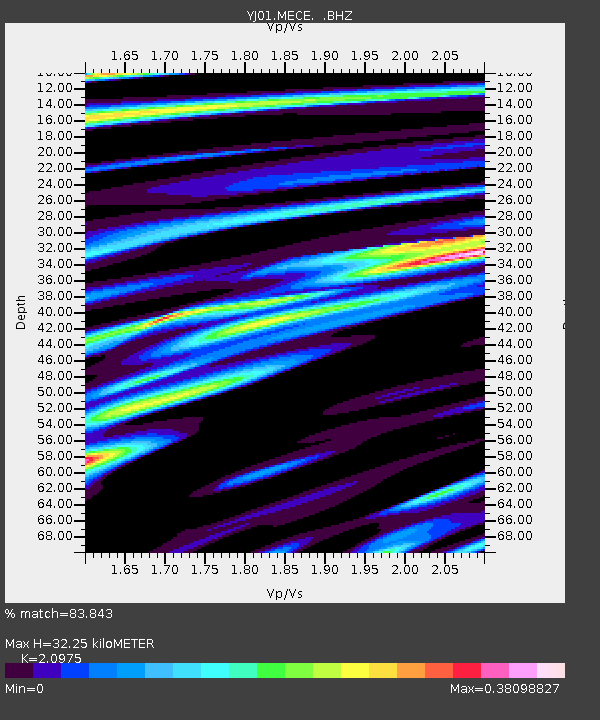
| Estimated Moho Depth: |
32.25 km |
| Estimated Crust Vp/Vs: |
2.10 |
| Assumed Crust Vp: |
6.643 km/s |
| Estimated Crust Vs: |
3.167 km/s |
| Estimated Crust Poisson's Ratio: |
0.35 |
|
| Radial Match: |
83.843 % |
| Radial Bump: |
247 |
| Transverse Match: |
60.368023 % |
| Transverse Bump: |
400 |
| SOD ConfigId: |
20082 |
| Insert Time: |
2010-03-09 00:43:44.934 +0000 |
| GWidth: |
2.5 |
| Max Bumps: |
400 |
| Tol: |
0.001 |
|

Signal To Noise
| Channel | StoN | STA | LTA |
| YJ:MECE: :BHZ:20020303T12:14:42.980013Z | 0.9855858 | 4.2422633E-7 | 4.3043062E-7 |
| YJ:MECE: :BHN:20020303T12:14:42.980013Z | 0.63505745 | 2.4365548E-7 | 3.8367472E-7 |
| YJ:MECE: :BHE:20020303T12:14:42.980013Z | 0.7907298 | 1.6739314E-7 | 2.1169447E-7 |
| Arrivals |
| Ps | 5.7 SECOND |
| PpPs | 14 SECOND |
| PsPs/PpSs | 20 SECOND |


