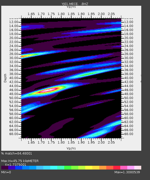
MECE Mechara High School - Earthquake Result Viewer

Earthquake location: Northern Sumatra, Indonesia
Earthquake latitude/longitude: 3.0/96.4
Earthquake time(UTC): 2002/11/02 (306) 09:46:46 GMT
Earthquake Depth: 27 km
Earthquake Magnitude: 5.9 MB, 6.4 MS, 6.4 MW, 6.1 MW
Earthquake Catalog/Contributor: WHDF/NEIC
Network: YJ Ethiopia-Afar Geoscientific Lithospheric Experiment
Station: MECE Mechara High School
Lat/Lon: 8.59 N/40.32 E
Elevation: 1775 m
Distance: 56.0 deg
Az: 278.32 deg
Baz: 92.221 deg
Ray Param: 0.06437004
Estimated Moho Depth: 45.75 km
Estimated Crust Vp/Vs: 1.74
Assumed Crust Vp: 6.643 km/s
Estimated Crust Vs: 3.824 km/s
Estimated Crust Poisson's Ratio: 0.25
Radial Match: 84.48001 %
Radial Bump: 400
Transverse Match: 52.44375 %
Transverse Bump: 400
SOD ConfigId: 16820
Insert Time: 2010-03-09 00:43:46.633 +0000
GWidth: 2.5
Max Bumps: 400
Tol: 0.001

Signal To Noise

ChannelStoNSTALTA
YJ:MECE: :BHZ:20021102T09:55:52.100024Z0.792274242.7024223E-63.4109682E-6
YJ:MECE: :BHN:20021102T09:55:52.100024Z1.22550891.3337353E-71.0883114E-7
YJ:MECE: :BHE:20021102T09:55:52.100024Z2.93967322.1744403E-77.396878E-8
Arrivals
Ps5.4 SECOND
PpPs18 SECOND
PsPs/PpSs23 SECOND