You are here: Home > Network List > YJ01 - Ethiopia-Afar Geoscientific Lithospheric Experiment Stations List
> Station MELE Melka Werer High School > Earthquake Result Viewer
MELE Melka Werer High School - Earthquake Result Viewer
| Earthquake location: |
Minahassa Peninsula, Sulawesi |
| Earthquake latitude/longitude: |
-0.0/122.9 |
| Earthquake time(UTC): |
2001/12/09 (343) 18:15:02 GMT |
| Earthquake Depth: |
156 km |
| Earthquake Magnitude: |
5.7 MB, 6.2 MW, 6.0 MW |
| Earthquake Catalog/Contributor: |
WHDF/NEIC |
|
| Network: |
YJ Ethiopia-Afar Geoscientific Lithospheric Experiment |
| Station: |
MELE Melka Werer High School |
| Lat/Lon: |
9.31 N/40.20 E |
| Elevation: |
762 m |
|
| Distance: |
82.8 deg |
| Az: |
279.324 deg |
| Baz: |
91.187 deg |
| Ray Param: |
0.046296023 |
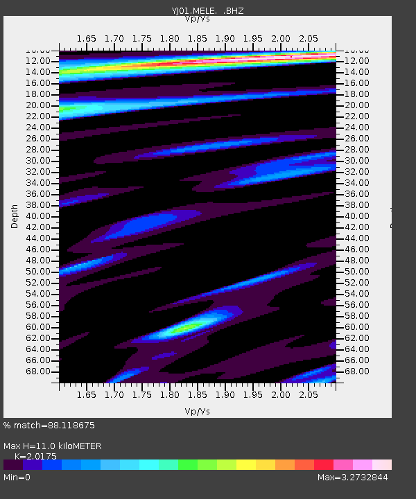
| Estimated Moho Depth: |
11.0 km |
| Estimated Crust Vp/Vs: |
2.02 |
| Assumed Crust Vp: |
6.643 km/s |
| Estimated Crust Vs: |
3.293 km/s |
| Estimated Crust Poisson's Ratio: |
0.34 |
|
| Radial Match: |
88.118675 % |
| Radial Bump: |
400 |
| Transverse Match: |
79.669304 % |
| Transverse Bump: |
400 |
| SOD ConfigId: |
20082 |
| Insert Time: |
2010-03-09 00:44:02.111 +0000 |
| GWidth: |
2.5 |
| Max Bumps: |
400 |
| Tol: |
0.001 |
|

Signal To Noise
| Channel | StoN | STA | LTA |
| YJ:MELE: :BHZ:20011209T18:26:37.959009Z | 0.9271055 | 1.762575E-7 | 1.901159E-7 |
| YJ:MELE: :BHN:20011209T18:26:37.959009Z | 0.9189488 | 1.6967385E-7 | 1.8463906E-7 |
| YJ:MELE: :BHE:20011209T18:26:37.959009Z | 2.4206498 | 2.619198E-7 | 1.0820227E-7 |
| Arrivals |
| Ps | 1.7 SECOND |
| PpPs | 4.9 SECOND |
| PsPs/PpSs | 6.6 SECOND |


