You are here: Home > Network List > YJ01 - Ethiopia-Afar Geoscientific Lithospheric Experiment Stations List
> Station NURE Nura Hira School > Earthquake Result Viewer
NURE Nura Hira School - Earthquake Result Viewer
| Earthquake location: |
South Sandwich Islands Region |
| Earthquake latitude/longitude: |
-56.5/-27.5 |
| Earthquake time(UTC): |
2002/11/12 (316) 01:46:48 GMT |
| Earthquake Depth: |
120 km |
| Earthquake Magnitude: |
6.0 MB, 6.3 MW, 6.2 MW |
| Earthquake Catalog/Contributor: |
WHDF/NEIC |
|
| Network: |
YJ Ethiopia-Afar Geoscientific Lithospheric Experiment |
| Station: |
NURE Nura Hira School |
| Lat/Lon: |
8.73 N/39.80 E |
| Elevation: |
1182 m |
|
| Distance: |
85.1 deg |
| Az: |
66.283 deg |
| Baz: |
210.856 deg |
| Ray Param: |
0.044742458 |
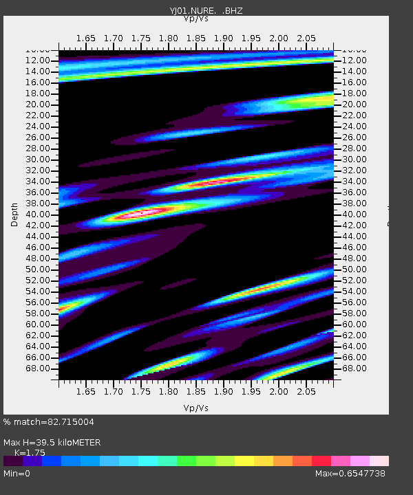
| Estimated Moho Depth: |
39.5 km |
| Estimated Crust Vp/Vs: |
1.75 |
| Assumed Crust Vp: |
6.464 km/s |
| Estimated Crust Vs: |
3.693 km/s |
| Estimated Crust Poisson's Ratio: |
0.26 |
|
| Radial Match: |
82.715004 % |
| Radial Bump: |
400 |
| Transverse Match: |
73.335464 % |
| Transverse Bump: |
400 |
| SOD ConfigId: |
16820 |
| Insert Time: |
2010-03-09 00:44:33.929 +0000 |
| GWidth: |
2.5 |
| Max Bumps: |
400 |
| Tol: |
0.001 |
|

Signal To Noise
| Channel | StoN | STA | LTA |
| YJ:NURE: :BHZ:20021112T01:58:40.260007Z | 1.8330326 | 1.7308342E-7 | 9.442463E-8 |
| YJ:NURE: :BHN:20021112T01:58:40.260007Z | 0.8778617 | 1.11273735E-7 | 1.2675544E-7 |
| YJ:NURE: :BHE:20021112T01:58:40.260007Z | 2.081478 | 1.4769327E-7 | 7.0955956E-8 |
| Arrivals |
| Ps | 4.7 SECOND |
| PpPs | 16 SECOND |
| PsPs/PpSs | 21 SECOND |


