You are here: Home > Network List > XC00 - Yellowstone Intermountain Seismic Array Stations List
> Station Y19 Y19 > Earthquake Result Viewer
Y19 Y19 - Earthquake Result Viewer
| Earthquake location: |
Tonga Islands |
| Earthquake latitude/longitude: |
-17.9/-175.3 |
| Earthquake time(UTC): |
2000/10/31 (305) 18:43:20 GMT |
| Earthquake Depth: |
33 km |
| Earthquake Magnitude: |
5.8 MB, 5.9 MS, 6.1 MW |
| Earthquake Catalog/Contributor: |
WHDF/NEIC |
|
| Network: |
XC Yellowstone Intermountain Seismic Array |
| Station: |
Y19 Y19 |
| Lat/Lon: |
43.62 N/110.60 W |
| Elevation: |
2091 m |
|
| Distance: |
85.1 deg |
| Az: |
41.229 deg |
| Baz: |
239.8 deg |
| Ray Param: |
0.04498236 |
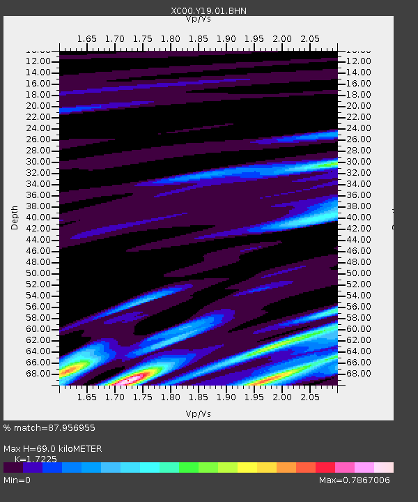
| Estimated Moho Depth: |
69.0 km |
| Estimated Crust Vp/Vs: |
1.72 |
| Assumed Crust Vp: |
6.207 km/s |
| Estimated Crust Vs: |
3.603 km/s |
| Estimated Crust Poisson's Ratio: |
0.25 |
|
| Radial Match: |
87.956955 % |
| Radial Bump: |
400 |
| Transverse Match: |
68.68488 % |
| Transverse Bump: |
400 |
| SOD ConfigId: |
16820 |
| Insert Time: |
2010-02-26 15:05:28.879 +0000 |
| GWidth: |
2.5 |
| Max Bumps: |
400 |
| Tol: |
0.001 |
|

Signal To Noise
| Channel | StoN | STA | LTA |
| XC:Y19:01:BHN:20001031T18:55:22.219011Z | 0.69143236 | 3.3947006E-7 | 4.909664E-7 |
| XC:Y19:01:BHE:20001031T18:55:22.219011Z | 1.5286186 | 3.8916005E-7 | 2.5458283E-7 |
| XC:Y19:01:BHZ:20001031T18:55:22.219011Z | 2.4577107 | 8.4483565E-7 | 3.43749E-7 |
| Arrivals |
| Ps | 8.2 SECOND |
| PpPs | 30 SECOND |
| PsPs/PpSs | 38 SECOND |


