
Station XC Y19 - Y19
Network: XC00 - Yellowstone Intermountain Seismic Array
Nearby stations (2 deg radius)
| Station | Name | (Lat, Lon) | Start / End | Elevation |
| Y19 | Y19 | (43.62, -110.60) | 2000-06-26 / 2001-12-31 | 2091 m |
| Crust2 Type: | M8,thick extended crust, 1.5 km seds. |
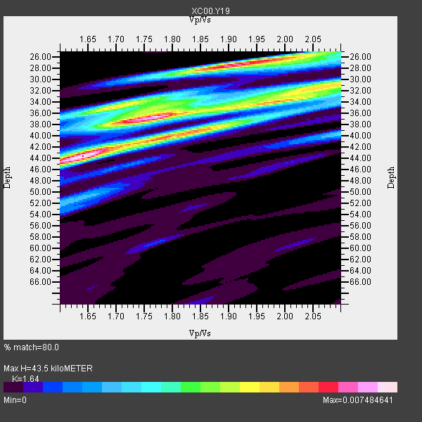
| Thickness Estimate: | 44 km |
| Thickness StdDev: | 6.1 km |
| Vp/Vs Estimate: | 1.64 |
| Vp/Vs StdDev: | 0.14 |
| Vs Estimate: | 3.785 km/s |
| Poisson's Ratio: | 0.20 |
| Peak Value: | 0.01 |
| Assumed Vp: | 6.207 km/s |
| Ps Weight: | 0.33333334 |
| PpPs Weight: | 0.33333334 |
| PsPs Weight: | 0.33333328 |
| Residual Complexity: | 0.856 |
| Nearby stations H: | 43 km +- 1.4 km |
| (2.0 deg) Vp/Vs: | 1.67 +- 0.04 |
5 with match > 90% ( 31.25 %) and 16 with match > 80% ( 100.0 %) out of 16.
Download stack as xyz text file.
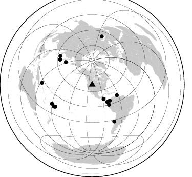
Azimuth Distribution of Events:
Prior Results for this Station
| Study | Thickness | Vp/Vs | Vp | Vs | Poissons Ratio | Extra |
| EARS | 44 km | 1.64 | 6.207 km/s | 3.785 km/s | 0.20 | |
| Crust2.0 | 37 km | 1.78 | 6.207 km/s | 3.489 km/s | 0.27 | M8,thick extended crust, 1.5 km seds. |
| Global Maxima | 44 km | 1.64 | 6.207 km/s | 3.785 km/s | 0.20 | amp=0.007484641 |
| Local Maxima 1 | 27 km | 1.91 | 6.207 km/s | 3.25 km/s | 0.31 | amp=0.006432069 |
| Local Maxima 2 | 36 km | 1.77 | 6.207 km/s | 3.497 km/s | 0.27 | amp=0.006313294 |
| Local Maxima 3 | 39 km | 1.84 | 6.207 km/s | 3.373 km/s | 0.29 | amp=0.0051948987 |
| Local Maxima 4 | 31 km | 2.08 | 6.207 km/s | 2.98 km/s | 0.35 | amp=0.0042341184 |
| Predicted Arrivals for vertical incidence (zero ray parameter) | |
| Ps | 4.49 SECOND |
| PpPs | 18.50 SECOND |
| PsPs/PpSs | 22.99 SECOND |
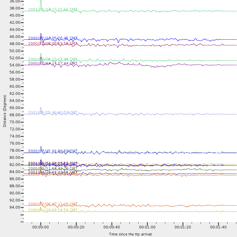
Events Processed for this Station
Download zip of receiver functions as SAC
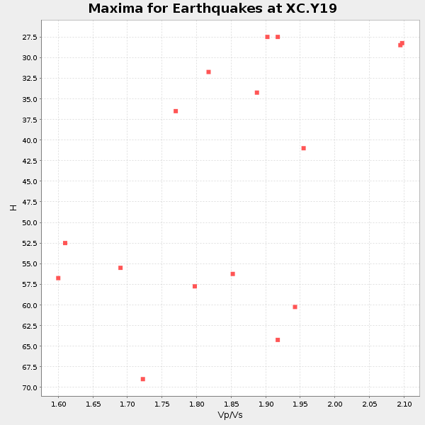
Plot maxima for each earthquake.
Events Used in the Stack
(16 events)| Radial Match | Distance | Baz | FERegion | Time | Lat/Lon | Depth | Magnitude |
| 96.14304 | 35.8 deg | 141.537 deg | El Salvador | 2001/01/13 17:33:32 GMT | (13.0, -88.7) | 60 km | 6.4 MB, 7.8 MS, 7.7 MW, 7.5 ME |
| 95.993515 | 67.8 deg | 310.365 deg | Kuril Islands | 2001/05/25 00:40:50 GMT | (44.3, 148.4) | 33 km | 6.1 MB, 6.7 MS, 6.7 MW, 6.6 MW |
| 92.36203 | 83.3 deg | 148.873 deg | Off Coast Of Central Chile | 2001/04/09 09:00:57 GMT | (-32.7, -73.1) | 11 km | 6.1 MB, 6.3 MS, 6.7 MW, 6.3 ME |
| 92.126785 | 83.7 deg | 239.249 deg | Tonga Islands | 2000/09/26 06:17:52 GMT | (-17.2, -173.9) | 56 km | 6.1 MB, 6.1 MS, 6.4 MW, 6.1 ME |
| 90.19661 | 83.6 deg | 311.844 deg | Western Honshu, Japan | 2001/03/24 06:27:53 GMT | (34.1, 132.5) | 50 km | 6.4 MB, 6.5 MS, 6.8 MW, 6.4 ME |
| 89.51748 | 98.0 deg | 272.095 deg | New Ireland Region, P.N.G. | 2000/11/16 04:54:56 GMT | (-4.0, 152.2) | 33 km | 6.0 MB, 8.2 MS, 8.0 MW, 8.0 ME |
| 88.49608 | 79.8 deg | 307.841 deg | Near S. Coast Of Honshu, Japan | 2000/07/01 07:01:55 GMT | (34.2, 139.1) | 10 km | 6.0 MB, 6.1 MS, 6.2 MW, 6.2 MW |
| 87.956955 | 85.1 deg | 239.8 deg | Tonga Islands | 2000/10/31 18:43:20 GMT | (-17.9, -175.3) | 33 km | 5.8 MB, 5.9 MS, 6.1 MW |
| 87.87234 | 79.7 deg | 307.832 deg | Near S. Coast Of Honshu, Japan | 2000/07/15 01:30:30 GMT | (34.3, 139.3) | 10 km | 5.5 MB, 5.9 MS, 6.1 MW, 6.0 MW |
| 87.72957 | 51.2 deg | 140.077 deg | Near Coast Of Ecuador | 2000/09/28 23:23:43 GMT | (-0.2, -80.6) | 23 km | 5.8 MB, 6.0 MS, 6.6 MW, 6.4 MW |
| 87.449776 | 96.2 deg | 11.3 deg | Turkmenistan | 2000/12/06 17:11:06 GMT | (39.6, 54.8) | 30 km | 6.7 MB, 7.5 MS, 7.0 MW, 6.9 ME |
| 84.27936 | 44.8 deg | 138.61 deg | South Of Panama | 2000/12/12 05:26:45 GMT | (6.0, -82.7) | 10 km | 5.8 MB, 5.7 MS, 6.3 ME, 6.1 MW |
| 81.863945 | 52.5 deg | 113.135 deg | Windward Islands | 2000/10/04 14:37:44 GMT | (11.1, -62.6) | 110 km | 5.6 MB, 5.4 MS, 6.1 MW, 5.9 MD |
| 81.55014 | 86.2 deg | 240.831 deg | Fiji Islands Region | 2001/04/28 04:49:53 GMT | (-18.1, -176.9) | 352 km | 6.2 MB, 6.8 MW, 6.8 MW |
| 81.14267 | 86.6 deg | 244.701 deg | Fiji Islands | 2000/09/14 14:59:57 GMT | (-15.7, 179.8) | 33 km | 5.7 MB, 6.2 MS, 6.3 MW, 6.2 MW |
| 80.11922 | 46.4 deg | 132.085 deg | Panama-Colombia Border Region | 2000/11/08 06:59:58 GMT | (7.0, -77.8) | 17 km | 6.0 MB, 6.4 MS, 6.5 MW, 6.2 ML |
Losers
(0 events)| Radial Match | Distance | Baz | FERegion | Time | Lat/Lon | Depth | Magnitude | Reason |
