You are here: Home > Network List > OK - Oklahoma Seismic Network Stations List
> Station AMES Ames, Oklahoma, USA > Earthquake Result Viewer
AMES Ames, Oklahoma, USA - Earthquake Result Viewer
| Earthquake location: |
Near Coast Of Central Chile |
| Earthquake latitude/longitude: |
-30.3/-71.6 |
| Earthquake time(UTC): |
2020/09/06 (250) 01:16:58 GMT |
| Earthquake Depth: |
31 km |
| Earthquake Magnitude: |
6.3 Mww |
| Earthquake Catalog/Contributor: |
NEIC PDE/us |
|
| Network: |
OK Oklahoma Seismic Network |
| Station: |
AMES Ames, Oklahoma, USA |
| Lat/Lon: |
36.34 N/98.19 W |
| Elevation: |
394 m |
|
| Distance: |
70.9 deg |
| Az: |
337.478 deg |
| Baz: |
155.787 deg |
| Ray Param: |
0.05465296 |
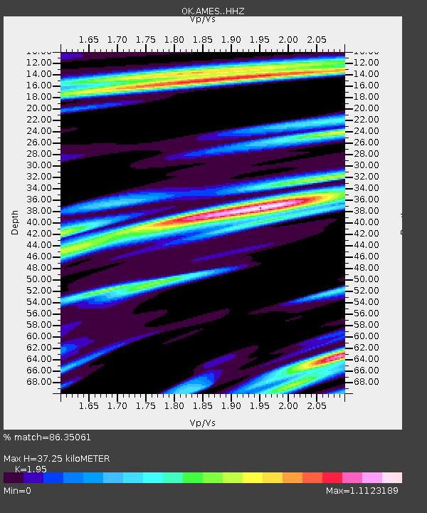
| Estimated Moho Depth: |
37.25 km |
| Estimated Crust Vp/Vs: |
1.95 |
| Assumed Crust Vp: |
6.426 km/s |
| Estimated Crust Vs: |
3.295 km/s |
| Estimated Crust Poisson's Ratio: |
0.32 |
|
| Radial Match: |
86.35061 % |
| Radial Bump: |
400 |
| Transverse Match: |
73.45452 % |
| Transverse Bump: |
400 |
| SOD ConfigId: |
22732711 |
| Insert Time: |
2020-09-20 01:35:37.457 +0000 |
| GWidth: |
2.5 |
| Max Bumps: |
400 |
| Tol: |
0.001 |
|

Signal To Noise
| Channel | StoN | STA | LTA |
| OK:AMES: :HHZ:20200906T01:27:41.914985Z | 3.349766 | 2.7418057E-6 | 8.185067E-7 |
| OK:AMES: :HHN:20200906T01:27:41.914985Z | 1.4460458 | 2.0496905E-6 | 1.4174451E-6 |
| OK:AMES: :HHE:20200906T01:27:41.914985Z | 1.0374473 | 1.5789183E-6 | 1.5219263E-6 |
| Arrivals |
| Ps | 5.7 SECOND |
| PpPs | 17 SECOND |
| PsPs/PpSs | 22 SECOND |


