You are here: Home > Network List > XC00 - Yellowstone Intermountain Seismic Array Stations List
> Station Y19 Y19 > Earthquake Result Viewer
Y19 Y19 - Earthquake Result Viewer
| Earthquake location: |
Fiji Islands Region |
| Earthquake latitude/longitude: |
-18.1/-176.9 |
| Earthquake time(UTC): |
2001/04/28 (118) 04:49:53 GMT |
| Earthquake Depth: |
352 km |
| Earthquake Magnitude: |
6.2 MB, 6.8 MW, 6.8 MW |
| Earthquake Catalog/Contributor: |
WHDF/NEIC |
|
| Network: |
XC Yellowstone Intermountain Seismic Array |
| Station: |
Y19 Y19 |
| Lat/Lon: |
43.62 N/110.60 W |
| Elevation: |
2091 m |
|
| Distance: |
86.2 deg |
| Az: |
41.805 deg |
| Baz: |
240.831 deg |
| Ray Param: |
0.04329155 |
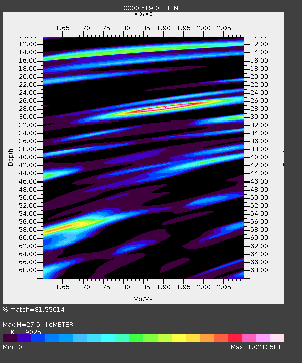
| Estimated Moho Depth: |
27.5 km |
| Estimated Crust Vp/Vs: |
1.90 |
| Assumed Crust Vp: |
6.207 km/s |
| Estimated Crust Vs: |
3.262 km/s |
| Estimated Crust Poisson's Ratio: |
0.31 |
|
| Radial Match: |
81.55014 % |
| Radial Bump: |
400 |
| Transverse Match: |
77.43283 % |
| Transverse Bump: |
400 |
| SOD ConfigId: |
4714 |
| Insert Time: |
2010-02-26 15:05:37.100 +0000 |
| GWidth: |
2.5 |
| Max Bumps: |
400 |
| Tol: |
0.001 |
|

Signal To Noise
| Channel | StoN | STA | LTA |
| XC:Y19:01:BHN:20010428T05:01:24.862007Z | 2.2313511 | 1.5882055E-7 | 7.1176856E-8 |
| XC:Y19:01:BHE:20010428T05:01:24.862007Z | 3.38976 | 1.7872678E-7 | 5.2725497E-8 |
| XC:Y19:01:BHZ:20010428T05:01:24.862007Z | 7.903271 | 8.121987E-7 | 1.0276741E-7 |
| Arrivals |
| Ps | 4.1 SECOND |
| PpPs | 13 SECOND |
| PsPs/PpSs | 17 SECOND |


