You are here: Home > Network List > XB96 - Abitibi Experiment Stations List
> Station DEST Destor > Earthquake Result Viewer
DEST Destor - Earthquake Result Viewer
| Earthquake location: |
Cyprus Region |
| Earthquake latitude/longitude: |
34.6/32.1 |
| Earthquake time(UTC): |
1996/10/09 (283) 13:10:52 GMT |
| Earthquake Depth: |
33 km |
| Earthquake Magnitude: |
6.4 MB, 6.8 MS, 7.2 UNKNOWN, 6.8 MW |
| Earthquake Catalog/Contributor: |
WHDF/NEIC |
|
| Network: |
XB Abitibi Experiment |
| Station: |
DEST Destor |
| Lat/Lon: |
48.46 N/78.99 W |
| Elevation: |
289 m |
|
| Distance: |
77.1 deg |
| Az: |
320.428 deg |
| Baz: |
52.177 deg |
| Ray Param: |
0.050513316 |
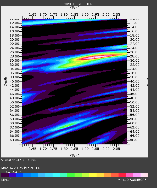
| Estimated Moho Depth: |
28.25 km |
| Estimated Crust Vp/Vs: |
1.94 |
| Assumed Crust Vp: |
6.61 km/s |
| Estimated Crust Vs: |
3.403 km/s |
| Estimated Crust Poisson's Ratio: |
0.32 |
|
| Radial Match: |
85.664604 % |
| Radial Bump: |
267 |
| Transverse Match: |
72.41883 % |
| Transverse Bump: |
331 |
| SOD ConfigId: |
6273 |
| Insert Time: |
2010-03-09 00:53:33.280 +0000 |
| GWidth: |
2.5 |
| Max Bumps: |
400 |
| Tol: |
0.001 |
|

Signal To Noise
| Channel | StoN | STA | LTA |
| XB:DEST: :BHN:19961009T13:22:11.037012Z | 2.0745375 | 1.0951316E-6 | 5.278919E-7 |
| XB:DEST: :BHE:19961009T13:22:11.037012Z | 2.8531806 | 1.4912442E-6 | 5.226603E-7 |
| XB:DEST: :BHZ:19961009T13:22:11.037012Z | 5.434086 | 4.6771693E-6 | 8.607095E-7 |
| Arrivals |
| Ps | 4.1 SECOND |
| PpPs | 12 SECOND |
| PsPs/PpSs | 16 SECOND |


