
Station XB DEST - Destor
Network: XB96 - Abitibi Experiment
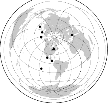
Nearby stations (2 deg radius)
| Station | Name | (Lat, Lon) | Start / End | Elevation |
| DEST | Destor | (48.46, -78.99) | 1996-05-17 / 1996-12-31 | 289 m |
| Crust2 Type: | H1,early/mid Proter., no seds. |
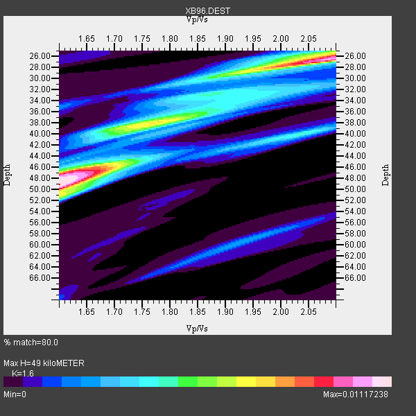
| Thickness Estimate: | 49 km |
| Thickness StdDev: | 9.6 km |
| Vp/Vs Estimate: | 1.60 |
| Vp/Vs StdDev: | 0.20 |
| Vs Estimate: | 4.131 km/s |
| Poisson's Ratio: | 0.18 |
| Peak Value: | 0.01 |
| Assumed Vp: | 6.61 km/s |
| Ps Weight: | 0.33333334 |
| PpPs Weight: | 0.33333334 |
| PsPs Weight: | 0.33333328 |
| Residual Complexity: | 0.834 |
| Nearby stations H: | +- |
| (2.0 deg) Vp/Vs: | +- |
6 with match > 90% ( 20.689655 %) and 10 with match > 80% ( 34.482758 %) out of 29.
Download stack as xyz text file.
Azimuth Distribution of Events:
Prior Results for this Station
| Study | Thickness | Vp/Vs | Vp | Vs | Poissons Ratio | Extra |
| EARS | 49 km | 1.60 | 6.61 km/s | 4.131 km/s | 0.18 | |
| Crust2.0 | 40 km | 1.77 | 6.61 km/s | 3.725 km/s | 0.27 | H1,early/mid Proter., no seds. |
| Global Maxima | 49 km | 1.60 | 6.61 km/s | 4.131 km/s | 0.18 | amp=0.01117238 |
| Local Maxima 1 | 26 km | 2.10 | 6.61 km/s | 3.151 km/s | 0.35 | amp=0.010299618 |
| Local Maxima 2 | 46 km | 1.64 | 6.61 km/s | 4.018 km/s | 0.21 | amp=0.007303891 |
| Local Maxima 3 | 38 km | 1.77 | 6.61 km/s | 3.734 km/s | 0.27 | amp=0.0064970143 |
| Local Maxima 4 | 40 km | 2.05 | 6.61 km/s | 3.228 km/s | 0.34 | amp=0.0038578091 |
| Predicted Arrivals for vertical incidence (zero ray parameter) | |
| Ps | 4.45 SECOND |
| PpPs | 19.27 SECOND |
| PsPs/PpSs | 23.72 SECOND |
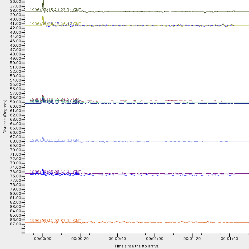
Events Processed for this Station
Download zip of receiver functions as SAC
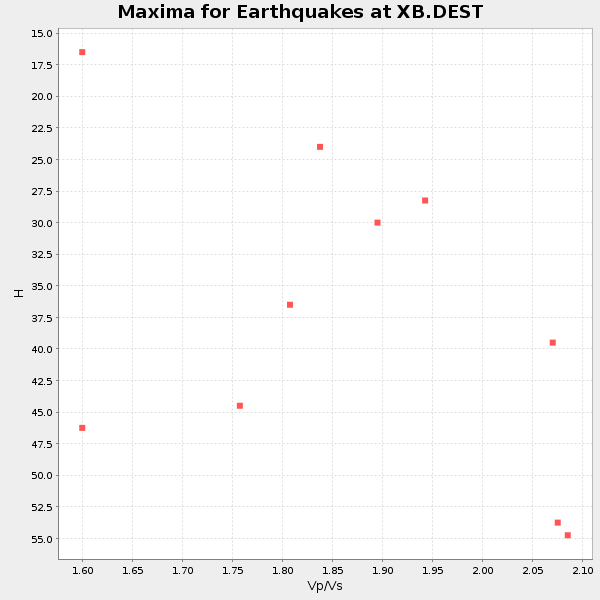
Plot maxima for each earthquake.
Events Used in the Stack
(10 events)| Radial Match | Distance | Baz | FERegion | Time | Lat/Lon | Depth | Magnitude |
| 98.32489 | 58.6 deg | 313.715 deg | Andreanof Islands, Aleutian Is. | 1996/06/10 04:03:35 GMT | (51.6, -177.6) | 33 km | 6.6 MB, 7.6 MS, 7.9 UNKNOWN, 7.4 MS |
| 98.19291 | 58.3 deg | 313.272 deg | Andreanof Islands, Aleutian Is. | 1996/06/10 15:24:56 GMT | (51.5, -176.8) | 26 km | 5.9 MB, 7.1 MS, 7.2 UNKNOWN, 6.9 MS |
| 97.538506 | 68.7 deg | 325.329 deg | Off East Coast Of Kamchatka | 1996/06/21 13:57:10 GMT | (51.6, 159.1) | 20 km | 6.0 MB, 6.6 MS, 7.0 UNKNOWN, 6.5 MS |
| 92.52309 | 35.6 deg | 217.808 deg | Guerrero, Mexico | 1996/07/15 21:23:34 GMT | (17.6, -101.0) | 18 km | 5.7 MB, 6.5 MS, 6.6 UNKNOWN, 6.2 ME |
| 92.21784 | 58.9 deg | 313.881 deg | Andreanof Islands, Aleutian Is. | 1996/06/08 23:19:15 GMT | (51.5, -178.1) | 33 km | 5.9 MB, 6.3 MS, 6.5 UNKNOWN, 6.1 MS |
| 92.151825 | 76.7 deg | 212.61 deg | Easter Island Region | 1996/09/05 08:14:14 GMT | (-22.1, -113.4) | 10 km | 6.2 MB, 7.0 MS, 7.0 UNKNOWN, 6.9 MW |
| 88.89271 | 39.2 deg | 188.254 deg | Costa Rica | 1996/09/04 19:06:49 GMT | (9.4, -84.3) | 33 km | 5.8 MB, 5.9 MS, 6.2 UNKNOWN, 6.1 MW |
| 88.78738 | 39.2 deg | 188.329 deg | Costa Rica | 1996/08/28 17:16:17 GMT | (9.4, -84.3) | 33 km | 5.5 MB, 5.5 MS, 5.9 UNKNOWN |
| 85.664604 | 77.1 deg | 52.177 deg | Cyprus Region | 1996/10/09 13:10:52 GMT | (34.6, 32.1) | 33 km | 6.4 MB, 6.8 MS, 7.2 UNKNOWN, 6.8 MW |
| 82.32057 | 89.1 deg | 328.429 deg | Near East Coast Of Honshu, Japan | 1996/09/11 02:37:14 GMT | (35.5, 140.9) | 55 km | 6.1 MB, 5.7 MS, 6.2 UNKNOWN, 6.1 MW |
Losers
(19 events)| Radial Match | Distance | Baz | FERegion | Time | Lat/Lon | Depth | Magnitude | Reason |
| 79.58843 | 31.8 deg | 289.795 deg | Vancouver Island, Canada Region | 1996/10/06 20:13:09 GMT | (49.0, -127.9) | 10 km | 5.8 MB, 6.3 MS, 6.2 UNKNOWN, 6.2 MW | |
| 78.68388 | 58.1 deg | 312.813 deg | Andreanof Islands, Aleutian Is. | 1996/06/11 10:40:08 GMT | (51.3, -176.3) | 33 km | 5.6 MB, 5.6 MS, 6.0 UNKNOWN, 5.5 MS | |
| 74.40822 | 80.3 deg | 173.594 deg | Near Coast Of Central Chile | 1996/09/09 00:20:39 GMT | (-31.9, -71.6) | 39 km | 6.0 MB, 5.5 MS, 6.0 UNKNOWN, 5.8 ME | |
| 74.28252 | 48.2 deg | 328.253 deg | Near N. Coast Of Eastern Siberia | 1996/10/24 19:31:53 GMT | (67.0, -173.2) | 20 km | 6.0 MB, 5.9 MS, 6.1 UNKNOWN, 5.8 ME | |
| 73.59678 | 63.6 deg | 330.753 deg | Kamchatka Peninsula, Russia | 1996/07/07 10:49:59 GMT | (58.6, 157.8) | 10 km | 5.6 MB, 5.6 MS, 5.8 UNKNOWN, 5.8 MW | |
| 70.47774 | 56.8 deg | 210.715 deg | Central East Pacific Rise | 1996/08/23 21:56:06 GMT | (-4.1, -104.4) | 10 km | 5.0 MB, 5.6 MS | |
| 70.44413 | 68.6 deg | 325.109 deg | Off East Coast Of Kamchatka | 1996/07/18 22:55:03 GMT | (51.5, 159.4) | 33 km | 5.5 MB, 5.2 MS | |
| 69.81221 | 71.9 deg | 171.705 deg | Near Coast Of Northern Chile | 1996/07/03 16:48:27 GMT | (-23.4, -70.4) | 33 km | 5.3 MB, 5.4 MS, 5.8 UNKNOWN | |
| 66.397125 | 86.2 deg | 330.162 deg | Eastern Honshu, Japan | 1996/08/10 18:12:17 GMT | (38.9, 140.5) | 10 km | 6.0 MB, 5.7 MS, 5.9 UNKNOWN, 5.9 MW | |
| 65.69091 | 55.1 deg | 311.352 deg | Fox Islands, Aleutian Islands | 1996/07/10 05:48:19 GMT | (52.2, -171.1) | 33 km | 5.9 ML, 5.4 MS, 5.3 MB | |
| 65.507454 | 68.8 deg | 325.155 deg | Off East Coast Of Kamchatka | 1996/06/22 14:50:07 GMT | (51.4, 159.2) | 33 km | 5.6 MB, 6.0 MS, 6.2 UNKNOWN, 6.2 MW | |
| 63.287586 | 32.7 deg | 291.671 deg | Vancouver Island, Canada Region | 1996/10/09 07:12:25 GMT | (49.7, -129.6) | 10 km | 5.7 MS, 5.3 MB, 5.8 UNKNOWN | |
| 62.50911 | 59.1 deg | 313.957 deg | Andreanof Islands, Aleutian Is. | 1996/08/19 04:19:16 GMT | (51.5, -178.4) | 33 km | 5.7 MB, 5.6 MS, 6.0 UNKNOWN, 5.7 ML | |
| 58.703358 | 59.0 deg | 313.858 deg | Andreanof Islands, Aleutian Is. | 1996/06/12 02:16:48 GMT | (51.4, -178.2) | 33 km | 5.5 MB, 5.3 MS, 5.7 UNKNOWN, 5.6 ML | |
| 57.29858 | 77.0 deg | 326.095 deg | Kuril Islands | 1996/10/02 11:24:48 GMT | (45.1, 151.2) | 33 km | 6.1 MB, 5.4 MS, 6.0 UNKNOWN, 6.0 MW | |
| 56.2709 | 89.6 deg | 9.202 deg | Southern Xinjiang, China | 1996/06/08 02:55:57 GMT | (41.7, 88.7) | 0.0 km | 5.9 MB, 4.3 MS | |
| 55.85861 | 37.3 deg | 190.523 deg | Nicaragua | 1996/09/18 17:34:20 GMT | (11.4, -85.5) | 193 km | 5.7 UNKNOWN, 5.3 MB, 5.5 MW | |
| 55.008755 | 70.8 deg | 329.907 deg | Sea Of Okhotsk | 1996/08/30 21:13:41 GMT | (52.3, 151.5) | 580 km | 5.5 UNKNOWN, 5.1 MB, 5.4 MW | |
| 53.18414 | 54.1 deg | 350.301 deg | Laptev Sea | 1996/06/22 16:47:12 GMT | (75.8, 134.6) | 10 km | 5.6 MB, 5.5 MS, 5.8 UNKNOWN, 5.7 MW |
