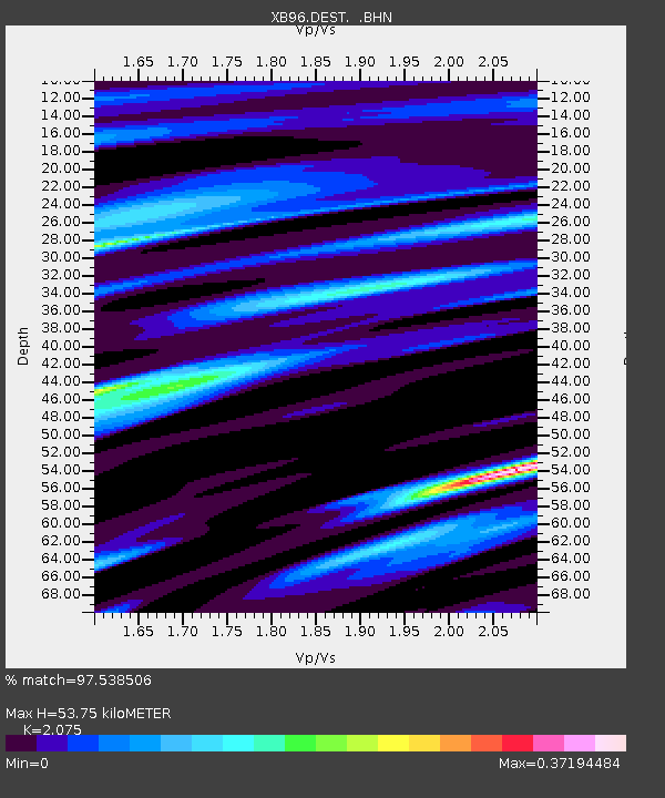
DEST Destor - Earthquake Result Viewer

Earthquake location: Off East Coast Of Kamchatka
Earthquake latitude/longitude: 51.6/159.1
Earthquake time(UTC): 1996/06/21 (173) 13:57:10 GMT
Earthquake Depth: 20 km
Earthquake Magnitude: 6.0 MB, 6.6 MS, 7.0 UNKNOWN, 6.5 MS
Earthquake Catalog/Contributor: WHDF/NEIC
Network: XB Abitibi Experiment
Station: DEST Destor
Lat/Lon: 48.46 N/78.99 W
Elevation: 289 m
Distance: 68.7 deg
Az: 37.349 deg
Baz: 325.329 deg
Ray Param: 0.056125373
Estimated Moho Depth: 53.75 km
Estimated Crust Vp/Vs: 2.08
Assumed Crust Vp: 6.61 km/s
Estimated Crust Vs: 3.186 km/s
Estimated Crust Poisson's Ratio: 0.35
Radial Match: 97.538506 %
Radial Bump: 292
Transverse Match: 83.87737 %
Transverse Bump: 400
SOD ConfigId: 6273
Insert Time: 2010-03-09 00:53:39.041 +0000
GWidth: 2.5
Max Bumps: 400
Tol: 0.001

Signal To Noise

ChannelStoNSTALTA
XB:DEST: :BHN:19960621T14:07:40.807007Z9.5044037.208842E-77.5847396E-8
XB:DEST: :BHE:19960621T14:07:40.807007Z8.8851574.5040358E-75.0691686E-8
XB:DEST: :BHZ:19960621T14:07:40.807007Z14.5141852.6379337E-61.8174866E-7
Arrivals
Ps9.0 SECOND
PpPs24 SECOND
PsPs/PpSs33 SECOND