You are here: Home > Network List > XB96 - Abitibi Experiment Stations List
> Station DEST Destor > Earthquake Result Viewer
DEST Destor - Earthquake Result Viewer
| Earthquake location: |
Guerrero, Mexico |
| Earthquake latitude/longitude: |
17.6/-101.0 |
| Earthquake time(UTC): |
1996/07/15 (197) 21:23:34 GMT |
| Earthquake Depth: |
18 km |
| Earthquake Magnitude: |
5.7 MB, 6.5 MS, 6.6 UNKNOWN, 6.2 ME |
| Earthquake Catalog/Contributor: |
WHDF/NEIC |
|
| Network: |
XB Abitibi Experiment |
| Station: |
DEST Destor |
| Lat/Lon: |
48.46 N/78.99 W |
| Elevation: |
289 m |
|
| Distance: |
35.6 deg |
| Az: |
25.329 deg |
| Baz: |
217.808 deg |
| Ray Param: |
0.077111766 |
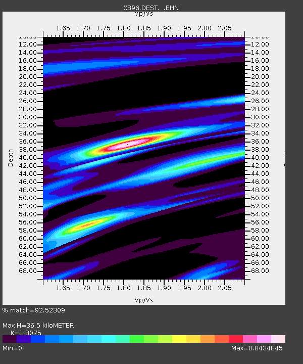
| Estimated Moho Depth: |
36.5 km |
| Estimated Crust Vp/Vs: |
1.81 |
| Assumed Crust Vp: |
6.61 km/s |
| Estimated Crust Vs: |
3.657 km/s |
| Estimated Crust Poisson's Ratio: |
0.28 |
|
| Radial Match: |
92.52309 % |
| Radial Bump: |
255 |
| Transverse Match: |
48.16778 % |
| Transverse Bump: |
400 |
| SOD ConfigId: |
6273 |
| Insert Time: |
2010-03-09 00:53:40.538 +0000 |
| GWidth: |
2.5 |
| Max Bumps: |
400 |
| Tol: |
0.001 |
|

Signal To Noise
| Channel | StoN | STA | LTA |
| XB:DEST: :BHN:19960715T21:29:59.811005Z | 7.7656484 | 9.105281E-7 | 1.1725075E-7 |
| XB:DEST: :BHE:19960715T21:29:59.811005Z | 6.5106616 | 7.4523507E-7 | 1.144638E-7 |
| XB:DEST: :BHZ:19960715T21:29:59.811005Z | 10.367805 | 2.2948861E-6 | 2.2134736E-7 |
| Arrivals |
| Ps | 4.8 SECOND |
| PpPs | 14 SECOND |
| PsPs/PpSs | 19 SECOND |


