You are here: Home > Network List > XB96 - Abitibi Experiment Stations List
> Station DEST Destor > Earthquake Result Viewer
DEST Destor - Earthquake Result Viewer
| Earthquake location: |
Easter Island Region |
| Earthquake latitude/longitude: |
-22.1/-113.4 |
| Earthquake time(UTC): |
1996/09/05 (249) 08:14:14 GMT |
| Earthquake Depth: |
10 km |
| Earthquake Magnitude: |
6.2 MB, 7.0 MS, 7.0 UNKNOWN, 6.9 MW |
| Earthquake Catalog/Contributor: |
WHDF/NEIC |
|
| Network: |
XB Abitibi Experiment |
| Station: |
DEST Destor |
| Lat/Lon: |
48.46 N/78.99 W |
| Elevation: |
289 m |
|
| Distance: |
76.7 deg |
| Az: |
22.759 deg |
| Baz: |
212.61 deg |
| Ray Param: |
0.05080147 |
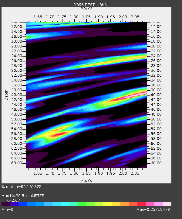
| Estimated Moho Depth: |
39.5 km |
| Estimated Crust Vp/Vs: |
2.07 |
| Assumed Crust Vp: |
6.61 km/s |
| Estimated Crust Vs: |
3.193 km/s |
| Estimated Crust Poisson's Ratio: |
0.35 |
|
| Radial Match: |
92.151825 % |
| Radial Bump: |
400 |
| Transverse Match: |
67.75515 % |
| Transverse Bump: |
400 |
| SOD ConfigId: |
6273 |
| Insert Time: |
2010-03-09 00:53:41.414 +0000 |
| GWidth: |
2.5 |
| Max Bumps: |
400 |
| Tol: |
0.001 |
|

Signal To Noise
| Channel | StoN | STA | LTA |
| XB:DEST: :BHN:19960905T08:25:34.407996Z | 2.2055655 | 4.344563E-7 | 1.9698182E-7 |
| XB:DEST: :BHE:19960905T08:25:34.407996Z | 0.74555445 | 3.1070388E-7 | 4.1674204E-7 |
| XB:DEST: :BHZ:19960905T08:25:34.407996Z | 2.830863 | 1.1492541E-6 | 4.0597305E-7 |
| Arrivals |
| Ps | 6.6 SECOND |
| PpPs | 18 SECOND |
| PsPs/PpSs | 24 SECOND |


