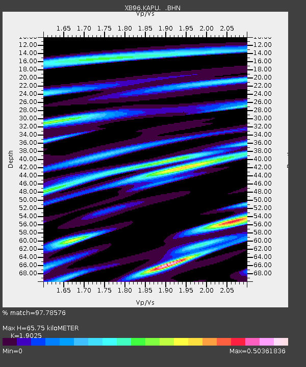
KAPU Kapuskasing Uplift (On) - Earthquake Result Viewer

Earthquake location: Near East Coast Of Honshu, Japan
Earthquake latitude/longitude: 35.5/140.9
Earthquake time(UTC): 1996/09/11 (255) 02:37:14 GMT
Earthquake Depth: 55 km
Earthquake Magnitude: 6.1 MB, 5.7 MS, 6.2 UNKNOWN, 6.1 MW
Earthquake Catalog/Contributor: WHDF/NEIC
Network: XB Abitibi Experiment
Station: KAPU Kapuskasing Uplift (On)
Lat/Lon: 48.13 N/82.91 W
Elevation: 0.0 m
Distance: 88.0 deg
Az: 27.672 deg
Baz: 325.573 deg
Ray Param: 0.042843133
Estimated Moho Depth: 65.75 km
Estimated Crust Vp/Vs: 1.90
Assumed Crust Vp: 6.467 km/s
Estimated Crust Vs: 3.399 km/s
Estimated Crust Poisson's Ratio: 0.31
Radial Match: 97.78576 %
Radial Bump: 194
Transverse Match: 92.301956 %
Transverse Bump: 295
SOD ConfigId: 6273
Insert Time: 2010-03-09 00:54:13.044 +0000
GWidth: 2.5
Max Bumps: 400
Tol: 0.001

Signal To Noise

ChannelStoNSTALTA
XB:KAPU: :BHN:19960911T02:49:27.689001Z5.065684.7370983E-79.351357E-8
XB:KAPU: :BHE:19960911T02:49:27.689001Z8.9625687.94808E-78.868083E-8
XB:KAPU: :BHZ:19960911T02:49:27.689001Z6.25737527.051426E-71.1268985E-7
Arrivals
Ps9.4 SECOND
PpPs29 SECOND
PsPs/PpSs38 SECOND