
Station XB KAPU - Kapuskasing Uplift (On)
Network: XB96 - Abitibi Experiment
Nearby stations (2 deg radius)
| Station | Name | (Lat, Lon) | Start / End | Elevation |
| KAPU | Kapuskasing Uplift (On) | (48.13, -82.91) | 1996-07-12 / 1996-12-31 | 0.0 m |
| Crust2 Type: | G6,Archean, no seds. |
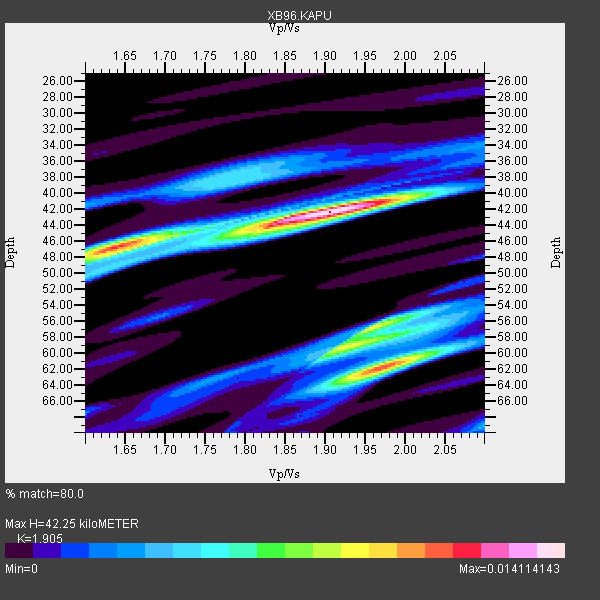
| Thickness Estimate: | 42 km |
| Thickness StdDev: | 8.4 km |
| Vp/Vs Estimate: | 1.90 |
| Vp/Vs StdDev: | 0.14 |
| Vs Estimate: | 3.395 km/s |
| Poisson's Ratio: | 0.31 |
| Peak Value: | 0.01 |
| Assumed Vp: | 6.467 km/s |
| Ps Weight: | 0.33333334 |
| PpPs Weight: | 0.33333334 |
| PsPs Weight: | 0.33333328 |
| Residual Complexity: | 0.721 |
| Nearby stations H: | +- |
| (2.0 deg) Vp/Vs: | +- |
5 with match > 90% ( 41.666668 %) and 6 with match > 80% ( 50.0 %) out of 12.
Download stack as xyz text file.
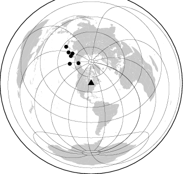
Azimuth Distribution of Events:
Prior Results for this Station
| Study | Thickness | Vp/Vs | Vp | Vs | Poissons Ratio | Extra |
| EARS | 42 km | 1.90 | 6.467 km/s | 3.395 km/s | 0.31 | |
| Crust2.0 | 45 km | 1.76 | 6.467 km/s | 3.667 km/s | 0.26 | G6,Archean, no seds. |
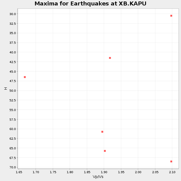
| Global Maxima | 42 km | 1.90 | 6.467 km/s | 3.395 km/s | 0.31 | amp=0.014114143 |
| Local Maxima 1 | 62 km | 1.97 | 6.467 km/s | 3.283 km/s | 0.33 | amp=0.010958693 |
| Local Maxima 2 | 57 km | 1.96 | 6.467 km/s | 3.304 km/s | 0.32 | amp=0.008789761 |
| Local Maxima 3 | 47 km | 1.63 | 6.467 km/s | 3.967 km/s | 0.20 | amp=0.008464972 |
| Local Maxima 4 | 59 km | 1.92 | 6.467 km/s | 3.368 km/s | 0.31 | amp=0.0067415205 |
| Predicted Arrivals for vertical incidence (zero ray parameter) | |
| Ps | 5.91 SECOND |
| PpPs | 18.98 SECOND |
| PsPs/PpSs | 24.89 SECOND |
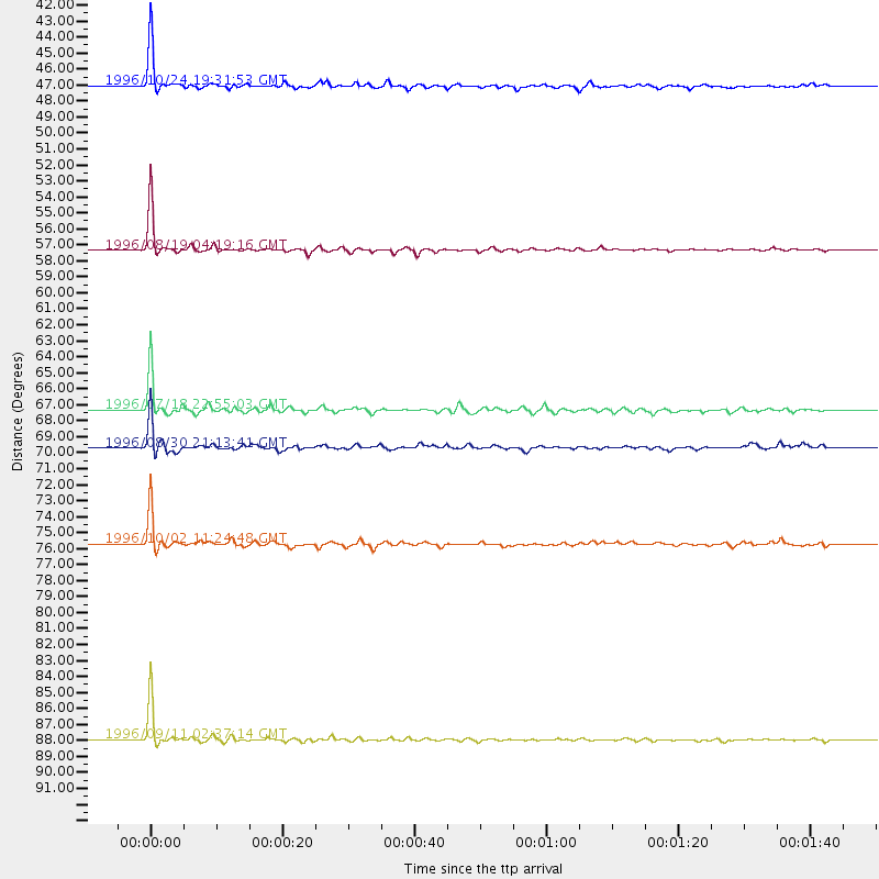
Events Processed for this Station
Download zip of receiver functions as SAC
Plot maxima for each earthquake.
Events Used in the Stack
(6 events)| Radial Match | Distance | Baz | FERegion | Time | Lat/Lon | Depth | Magnitude |
| 97.78576 | 88.0 deg | 325.573 deg | Near East Coast Of Honshu, Japan | 1996/09/11 02:37:14 GMT | (35.5, 140.9) | 55 km | 6.1 MB, 5.7 MS, 6.2 UNKNOWN, 6.1 MW |
| 95.20445 | 57.4 deg | 312.3 deg | Andreanof Islands, Aleutian Is. | 1996/08/19 04:19:16 GMT | (51.5, -178.4) | 33 km | 5.7 MB, 5.6 MS, 6.0 UNKNOWN, 5.7 ML |
| 94.50992 | 47.1 deg | 327.52 deg | Near N. Coast Of Eastern Siberia | 1996/10/24 19:31:53 GMT | (67.0, -173.2) | 20 km | 6.0 MB, 5.9 MS, 6.1 UNKNOWN, 5.8 ME |
| 93.72926 | 67.4 deg | 323.129 deg | Off East Coast Of Kamchatka | 1996/07/18 22:55:03 GMT | (51.5, 159.4) | 33 km | 5.5 MB, 5.2 MS |
| 91.62533 | 75.7 deg | 323.745 deg | Kuril Islands | 1996/10/02 11:24:48 GMT | (45.1, 151.2) | 33 km | 6.1 MB, 5.4 MS, 6.0 UNKNOWN, 6.0 MW |
| 85.52828 | 69.7 deg | 327.856 deg | Sea Of Okhotsk | 1996/08/30 21:13:41 GMT | (52.3, 151.5) | 580 km | 5.5 UNKNOWN, 5.1 MB, 5.4 MW |
Losers
(6 events)| Radial Match | Distance | Baz | FERegion | Time | Lat/Lon | Depth | Magnitude | Reason |
| 83.418434 | 38.7 deg | 182.15 deg | Costa Rica | 1996/09/04 19:06:49 GMT | (9.4, -84.3) | 33 km | 5.8 MB, 5.9 MS, 6.2 UNKNOWN, 6.1 MW | |
| 77.85448 | 80.3 deg | 170.227 deg | Near Coast Of Central Chile | 1996/09/09 00:20:39 GMT | (-31.9, -71.6) | 39 km | 6.0 MB, 5.5 MS, 6.0 UNKNOWN, 5.8 ME | |
| 72.82937 | 38.6 deg | 182.225 deg | Costa Rica | 1996/08/28 17:16:17 GMT | (9.4, -84.3) | 33 km | 5.5 MB, 5.5 MS, 5.9 UNKNOWN | |
| 72.039474 | 79.3 deg | 49.552 deg | Cyprus Region | 1996/10/09 13:10:52 GMT | (34.6, 32.1) | 33 km | 6.4 MB, 6.8 MS, 7.2 UNKNOWN, 6.8 MW | |
| 69.42532 | 55.3 deg | 206.359 deg | Central East Pacific Rise | 1996/08/23 21:56:06 GMT | (-4.1, -104.4) | 10 km | 5.0 MB, 5.6 MS | |
| 64.14302 | 36.6 deg | 184.217 deg | Nicaragua | 1996/09/18 17:34:20 GMT | (11.4, -85.5) | 193 km | 5.7 UNKNOWN, 5.3 MB, 5.5 MW |
