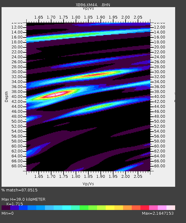
KM44 XB.KM44 - Earthquake Result Viewer

Earthquake location: Andreanof Islands, Aleutian Is.
Earthquake latitude/longitude: 51.5/-178.1
Earthquake time(UTC): 1996/06/08 (160) 23:19:15 GMT
Earthquake Depth: 33 km
Earthquake Magnitude: 5.9 MB, 6.3 MS, 6.5 UNKNOWN, 6.1 MS
Earthquake Catalog/Contributor: WHDF/NEIC
Network: XB Abitibi Experiment
Station: KM44 XB.KM44
Lat/Lon: 49.43 N/79.00 W
Elevation: 0.0 m
Distance: 58.2 deg
Az: 49.3 deg
Baz: 313.445 deg
Ray Param: 0.06291978
Estimated Moho Depth: 39.0 km
Estimated Crust Vp/Vs: 1.72
Assumed Crust Vp: 6.61 km/s
Estimated Crust Vs: 3.854 km/s
Estimated Crust Poisson's Ratio: 0.24
Radial Match: 87.8515 %
Radial Bump: 400
Transverse Match: 68.501 %
Transverse Bump: 400
SOD ConfigId: 6273
Insert Time: 2010-03-09 00:54:30.630 +0000
GWidth: 2.5
Max Bumps: 400
Tol: 0.001

Signal To Noise

ChannelStoNSTALTA
XB:KM44: :BHN:19960608T23:28:35.469019Z5.02133134.062368E-78.090221E-8
XB:KM44: :BHE:19960608T23:28:35.469019Z6.4813614.4023247E-76.792284E-8
XB:KM44: :BHZ:19960608T23:28:35.469019Z16.061115.163301E-73.214785E-8
Arrivals
Ps4.5 SECOND
PpPs15 SECOND
PsPs/PpSs20 SECOND