
Station XB KM44 - XB.KM44
Network: XB96 - Abitibi Experiment
Nearby stations (2 deg radius)
| Station | Name | (Lat, Lon) | Start / End | Elevation |
| KM44 | XB.KM44 | (49.43, -79.00) | 1996-05-21 / 1996-12-31 | 0.0 m |
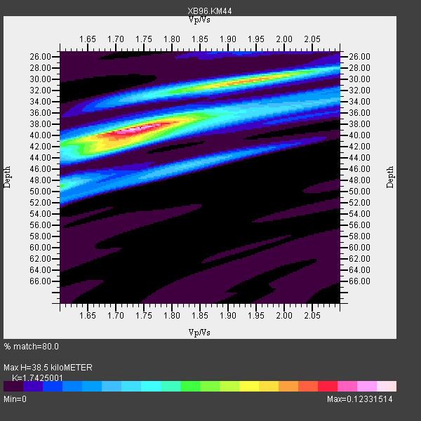
| Crust2 Type: | H1,early/mid Proter., no seds. |
| Thickness Estimate: | 38 km |
| Thickness StdDev: | 3.8 km |
| Vp/Vs Estimate: | 1.74 |
| Vp/Vs StdDev: | 0.09 |
| Vs Estimate: | 3.793 km/s |
| Poisson's Ratio: | 0.25 |
| Peak Value: | 0.12 |
| Assumed Vp: | 6.61 km/s |
| Ps Weight: | 0.33333334 |
| PpPs Weight: | 0.33333334 |
| PsPs Weight: | 0.33333328 |
| Residual Complexity: | 0.631 |
| Nearby stations H: | +- |
| (2.0 deg) Vp/Vs: | +- |
3 with match > 90% ( 17.647058 %) and 6 with match > 80% ( 35.294117 %) out of 17.
Download stack as xyz text file.
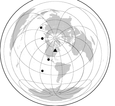
Azimuth Distribution of Events:
Prior Results for this Station
| Study | Thickness | Vp/Vs | Vp | Vs | Poissons Ratio | Extra |
| EARS | 38 km | 1.74 | 6.61 km/s | 3.793 km/s | 0.25 | |
| Crust2.0 | 40 km | 1.77 | 6.61 km/s | 3.725 km/s | 0.27 | H1,early/mid Proter., no seds. |
| Global Maxima | 38 km | 1.74 | 6.61 km/s | 3.793 km/s | 0.25 | amp=0.12331514 |
| Local Maxima 1 | 30 km | 1.93 | 6.61 km/s | 3.416 km/s | 0.32 | amp=0.08788991 |
| Local Maxima 2 | 42 km | 1.69 | 6.61 km/s | 3.911 km/s | 0.23 | amp=0.05587449 |
| Local Maxima 3 | 45 km | 1.83 | 6.61 km/s | 3.617 km/s | 0.29 | amp=0.03765336 |
| Local Maxima 4 | 40 km | 1.71 | 6.61 km/s | 3.86 km/s | 0.24 | amp=0.032581825 |
| Predicted Arrivals for vertical incidence (zero ray parameter) | |
| Ps | 4.32 SECOND |
| PpPs | 15.97 SECOND |
| PsPs/PpSs | 20.30 SECOND |
Events Processed for this Station
Download zip of receiver functions as SAC
Plot maxima for each earthquake.
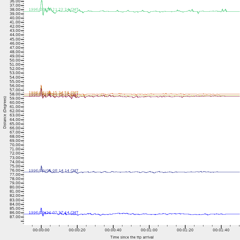
Events Used in the Stack
(6 events)| Radial Match | Distance | Baz | FERegion | Time | Lat/Lon | Depth | Magnitude |
| 97.535034 | 58.0 deg | 313.273 deg | Andreanof Islands, Aleutian Is. | 1996/06/10 04:03:35 GMT | (51.6, -177.6) | 33 km | 6.6 MB, 7.6 MS, 7.9 UNKNOWN, 7.4 MS |
| 96.80381 | 57.6 deg | 312.821 deg | Andreanof Islands, Aleutian Is. | 1996/06/10 15:24:56 GMT | (51.5, -176.8) | 26 km | 5.9 MB, 7.1 MS, 7.2 UNKNOWN, 6.9 MS |
| 91.35299 | 36.4 deg | 216.977 deg | Guerrero, Mexico | 1996/07/15 21:23:34 GMT | (17.6, -101.0) | 18 km | 5.7 MB, 6.5 MS, 6.6 UNKNOWN, 6.2 ME |
| 89.560104 | 77.5 deg | 212.481 deg | Easter Island Region | 1996/09/05 08:14:14 GMT | (-22.1, -113.4) | 10 km | 6.2 MB, 7.0 MS, 7.0 UNKNOWN, 6.9 MW |
| 89.01436 | 88.3 deg | 328.409 deg | Near East Coast Of Honshu, Japan | 1996/09/11 02:37:14 GMT | (35.5, 140.9) | 55 km | 6.1 MB, 5.7 MS, 6.2 UNKNOWN, 6.1 MW |
| 87.8515 | 58.2 deg | 313.445 deg | Andreanof Islands, Aleutian Is. | 1996/06/08 23:19:15 GMT | (51.5, -178.1) | 33 km | 5.9 MB, 6.3 MS, 6.5 UNKNOWN, 6.1 MS |
Losers
(11 events)| Radial Match | Distance | Baz | FERegion | Time | Lat/Lon | Depth | Magnitude | Reason |
| 78.500465 | 77.4 deg | 212.209 deg | Easter Island Region | 1996/09/05 09:10:20 GMT | (-22.1, -113.1) | 10 km | 5.6 MB, 6.3 MS | |
| 74.434746 | 57.5 deg | 312.356 deg | Andreanof Islands, Aleutian Is. | 1996/06/11 10:40:08 GMT | (51.3, -176.3) | 33 km | 5.6 MB, 5.6 MS, 6.0 UNKNOWN, 5.5 MS | |
| 69.15359 | 81.2 deg | 173.603 deg | Near Coast Of Central Chile | 1996/09/09 00:20:39 GMT | (-31.9, -71.6) | 39 km | 6.0 MB, 5.5 MS, 6.0 UNKNOWN, 5.8 ME | |
| 67.10698 | 77.4 deg | 212.194 deg | Easter Island Region | 1996/09/05 09:46:59 GMT | (-22.1, -113.1) | 10 km | 5.6 MB, 5.9 MS, 6.4 UNKNOWN | |
| 58.16081 | 67.9 deg | 325.102 deg | Off East Coast Of Kamchatka | 1996/06/21 13:57:10 GMT | (51.6, 159.1) | 20 km | 6.0 MB, 6.6 MS, 7.0 UNKNOWN, 6.5 MS | |
| 58.041115 | 54.4 deg | 310.827 deg | Fox Islands, Aleutian Islands | 1996/07/10 05:48:19 GMT | (52.2, -171.1) | 33 km | 5.9 ML, 5.4 MS, 5.3 MB | |
| 56.901737 | 68.0 deg | 324.927 deg | Off East Coast Of Kamchatka | 1996/06/22 14:50:07 GMT | (51.4, 159.2) | 33 km | 5.6 MB, 6.0 MS, 6.2 UNKNOWN, 6.2 MW | |
| 49.934013 | 85.4 deg | 330.118 deg | Eastern Honshu, Japan | 1996/08/10 18:12:17 GMT | (38.9, 140.5) | 10 km | 6.0 MB, 5.7 MS, 5.9 UNKNOWN, 5.9 MW | |
| 41.529995 | 58.4 deg | 313.524 deg | Andreanof Islands, Aleutian Is. | 1996/08/19 04:19:16 GMT | (51.5, -178.4) | 33 km | 5.7 MB, 5.6 MS, 6.0 UNKNOWN, 5.7 ML | |
| 35.474083 | 69.9 deg | 329.726 deg | Sea Of Okhotsk | 1996/08/30 21:13:41 GMT | (52.3, 151.5) | 580 km | 5.5 UNKNOWN, 5.1 MB, 5.4 MW | |
| 25.659206 | 51.3 deg | 182.565 deg | Off Coast Of Ecuador | 1996/08/05 21:39:16 GMT | (-2.0, -81.0) | 33 km | 5.7 MB, 5.9 MS, 6.2 UNKNOWN, 6.2 MW |
