You are here: Home > Network List > XB96 - Abitibi Experiment Stations List
> Station LDUF Lac Dufault > Earthquake Result Viewer
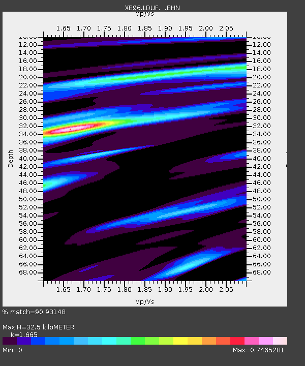
LDUF Lac Dufault - Earthquake Result Viewer
| Earthquake location: |
Easter Island Region |
| Earthquake latitude/longitude: |
-22.1/-113.4 |
| Earthquake time(UTC): |
1996/09/05 (249) 08:14:14 GMT |
| Earthquake Depth: |
10 km |
| Earthquake Magnitude: |
6.2 MB, 7.0 MS, 7.0 UNKNOWN, 6.9 MW |
| Earthquake Catalog/Contributor: |
WHDF/NEIC |
|
| Network: |
XB Abitibi Experiment |
| Station: |
LDUF Lac Dufault |
| Lat/Lon: |
48.32 N/78.94 W |
| Elevation: |
0.0 m |
|
| Distance: |
76.6 deg |
| Az: |
22.866 deg |
| Baz: |
212.673 deg |
| Ray Param: |
0.050868884 |
| Estimated Moho Depth: |
32.5 km |
| Estimated Crust Vp/Vs: |
1.66 |
| Assumed Crust Vp: |
6.61 km/s |
| Estimated Crust Vs: |
3.97 km/s |
| Estimated Crust Poisson's Ratio: |
0.22 |
|
| Radial Match: |
90.93148 % |
| Radial Bump: |
389 |
| Transverse Match: |
73.24223 % |
| Transverse Bump: |
400 |
| SOD ConfigId: |
6273 |
| Insert Time: |
2010-03-09 00:54:53.923 +0000 |
| GWidth: |
2.5 |
| Max Bumps: |
400 |
| Tol: |
0.001 |
|

Signal To Noise
| Channel | StoN | STA | LTA |
| XB:LDUF: :BHN:19960905T08:25:33.805029Z | 2.3634772 | 5.980768E-7 | 2.5304954E-7 |
| XB:LDUF: :BHE:19960905T08:25:33.805029Z | 1.183715 | 3.201791E-7 | 2.7048665E-7 |
| XB:LDUF: :BHZ:19960905T08:25:33.805029Z | 3.0725625 | 1.0344933E-6 | 3.366875E-7 |
| Arrivals |
| Ps | 3.4 SECOND |
| PpPs | 13 SECOND |
| PsPs/PpSs | 16 SECOND |


