
Station XB LDUF - Lac Dufault
Network: XB96 - Abitibi Experiment
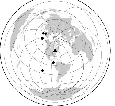
Nearby stations (2 deg radius)
| Station | Name | (Lat, Lon) | Start / End | Elevation |
| LDUF | Lac Dufault | (48.32, -78.94) | 1996-05-16 / 1996-12-31 | 0.0 m |
| Crust2 Type: | H1,early/mid Proter., no seds. |
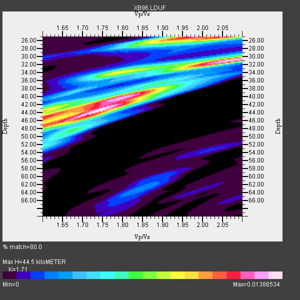
| Thickness Estimate: | 44 km |
| Thickness StdDev: | 7.3 km |
| Vp/Vs Estimate: | 1.71 |
| Vp/Vs StdDev: | 0.17 |
| Vs Estimate: | 3.865 km/s |
| Poisson's Ratio: | 0.24 |
| Peak Value: | 0.01 |
| Assumed Vp: | 6.61 km/s |
| Ps Weight: | 0.33333334 |
| PpPs Weight: | 0.33333334 |
| PsPs Weight: | 0.33333328 |
| Residual Complexity: | 0.823 |
| Nearby stations H: | +- |
| (2.0 deg) Vp/Vs: | +- |
6 with match > 90% ( 26.086956 %) and 9 with match > 80% ( 39.130436 %) out of 23.
Download stack as xyz text file.
Azimuth Distribution of Events:
Prior Results for this Station
| Study | Thickness | Vp/Vs | Vp | Vs | Poissons Ratio | Extra |
| EARS | 44 km | 1.71 | 6.61 km/s | 3.865 km/s | 0.24 | |
| Crust2.0 | 40 km | 1.77 | 6.61 km/s | 3.725 km/s | 0.27 | H1,early/mid Proter., no seds. |
| Global Maxima | 44 km | 1.71 | 6.61 km/s | 3.865 km/s | 0.24 | amp=0.01386534 |
| Local Maxima 1 | 31 km | 2.08 | 6.61 km/s | 3.186 km/s | 0.35 | amp=0.013245004 |
| Local Maxima 2 | 25 km | 1.98 | 6.61 km/s | 3.343 km/s | 0.33 | amp=0.01210296 |
| Local Maxima 3 | 45 km | 1.61 | 6.61 km/s | 4.099 km/s | 0.19 | amp=0.010335033 |
| Local Maxima 4 | 40 km | 1.79 | 6.61 km/s | 3.688 km/s | 0.27 | amp=0.009334516 |
| Predicted Arrivals for vertical incidence (zero ray parameter) | |
| Ps | 4.78 SECOND |
| PpPs | 18.24 SECOND |
| PsPs/PpSs | 23.02 SECOND |
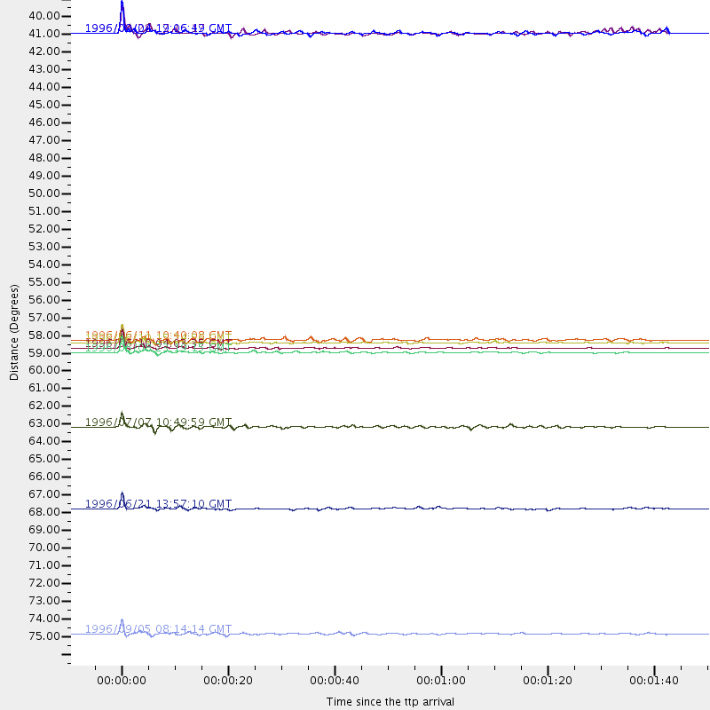
Events Processed for this Station
Download zip of receiver functions as SAC
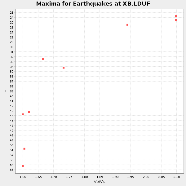
Plot maxima for each earthquake.
Events Used in the Stack
(9 events)| Radial Match | Distance | Baz | FERegion | Time | Lat/Lon | Depth | Magnitude |
| 98.87762 | 58.4 deg | 313.359 deg | Andreanof Islands, Aleutian Is. | 1996/06/10 15:24:56 GMT | (51.5, -176.8) | 26 km | 5.9 MB, 7.1 MS, 7.2 UNKNOWN, 6.9 MS |
| 98.32418 | 58.7 deg | 313.801 deg | Andreanof Islands, Aleutian Is. | 1996/06/10 04:03:35 GMT | (51.6, -177.6) | 33 km | 6.6 MB, 7.6 MS, 7.9 UNKNOWN, 7.4 MS |
| 92.987274 | 59.0 deg | 313.966 deg | Andreanof Islands, Aleutian Is. | 1996/06/08 23:19:15 GMT | (51.5, -178.1) | 33 km | 5.9 MB, 6.3 MS, 6.5 UNKNOWN, 6.1 MS |
| 91.19183 | 68.8 deg | 325.387 deg | Off East Coast Of Kamchatka | 1996/06/21 13:57:10 GMT | (51.6, 159.1) | 20 km | 6.0 MB, 6.6 MS, 7.0 UNKNOWN, 6.5 MS |
| 91.175476 | 39.1 deg | 188.357 deg | Costa Rica | 1996/09/04 19:06:49 GMT | (9.4, -84.3) | 33 km | 5.8 MB, 5.9 MS, 6.2 UNKNOWN, 6.1 MW |
| 90.93148 | 76.6 deg | 212.673 deg | Easter Island Region | 1996/09/05 08:14:14 GMT | (-22.1, -113.4) | 10 km | 6.2 MB, 7.0 MS, 7.0 UNKNOWN, 6.9 MW |
| 89.702576 | 63.7 deg | 330.81 deg | Kamchatka Peninsula, Russia | 1996/07/07 10:49:59 GMT | (58.6, 157.8) | 10 km | 5.6 MB, 5.6 MS, 5.8 UNKNOWN, 5.8 MW |
| 86.05759 | 58.3 deg | 312.9 deg | Andreanof Islands, Aleutian Is. | 1996/06/11 10:40:08 GMT | (51.3, -176.3) | 33 km | 5.6 MB, 5.6 MS, 6.0 UNKNOWN, 5.5 MS |
| 81.86833 | 39.1 deg | 188.433 deg | Costa Rica | 1996/08/28 17:16:17 GMT | (9.4, -84.3) | 33 km | 5.5 MB, 5.5 MS, 5.9 UNKNOWN |
Losers
(14 events)| Radial Match | Distance | Baz | FERegion | Time | Lat/Lon | Depth | Magnitude | Reason |
| 77.7327 | 80.1 deg | 173.635 deg | Near Coast Of Central Chile | 1996/09/09 00:20:39 GMT | (-31.9, -71.6) | 39 km | 6.0 MB, 5.5 MS, 6.0 UNKNOWN, 5.8 ME | |
| 76.2446 | 77.1 deg | 52.185 deg | Cyprus Region | 1996/10/09 13:10:52 GMT | (34.6, 32.1) | 33 km | 6.4 MB, 6.8 MS, 7.2 UNKNOWN, 6.8 MW | |
| 76.00209 | 31.9 deg | 290.027 deg | Vancouver Island, Canada Region | 1996/10/06 20:13:09 GMT | (49.0, -127.9) | 10 km | 5.8 MB, 6.3 MS, 6.2 UNKNOWN, 6.2 MW | |
| 71.3286 | 68.9 deg | 325.213 deg | Off East Coast Of Kamchatka | 1996/06/22 14:50:07 GMT | (51.4, 159.2) | 33 km | 5.6 MB, 6.0 MS, 6.2 UNKNOWN, 6.2 MW | |
| 70.33825 | 59.2 deg | 314.042 deg | Andreanof Islands, Aleutian Is. | 1996/08/19 04:19:16 GMT | (51.5, -178.4) | 33 km | 5.7 MB, 5.6 MS, 6.0 UNKNOWN, 5.7 ML | |
| 66.49291 | 59.1 deg | 313.942 deg | Andreanof Islands, Aleutian Is. | 1996/06/12 02:16:48 GMT | (51.4, -178.2) | 33 km | 5.5 MB, 5.3 MS, 5.7 UNKNOWN, 5.6 ML | |
| 55.821552 | 37.2 deg | 190.639 deg | Nicaragua | 1996/09/18 17:34:20 GMT | (11.4, -85.5) | 193 km | 5.7 UNKNOWN, 5.3 MB, 5.5 MW | |
| 54.98134 | 77.1 deg | 326.144 deg | Kuril Islands | 1996/10/02 11:24:48 GMT | (45.1, 151.2) | 33 km | 6.1 MB, 5.4 MS, 6.0 UNKNOWN, 6.0 MW | |
| 53.858295 | 68.4 deg | 325.124 deg | Off East Coast Of Kamchatka | 1996/06/30 11:32:35 GMT | (51.7, 159.8) | 33 km | 5.5 MB, 5.9 MS, 6.1 UNKNOWN, 6.0 MW | |
| 48.528725 | 71.8 deg | 171.747 deg | Near Coast Of Northern Chile | 1996/07/03 16:48:27 GMT | (-23.4, -70.4) | 33 km | 5.3 MB, 5.4 MS, 5.8 UNKNOWN | |
| 46.49411 | 89.7 deg | 9.239 deg | Southern Xinjiang, China | 1996/06/08 02:55:57 GMT | (41.7, 88.7) | 0.0 km | 5.9 MB, 4.3 MS | |
| 46.052826 | 54.2 deg | 350.331 deg | Laptev Sea | 1996/06/22 16:47:12 GMT | (75.8, 134.6) | 10 km | 5.6 MB, 5.5 MS, 5.8 UNKNOWN, 5.7 MW | |
| 45.87133 | 55.2 deg | 311.447 deg | Fox Islands, Aleutian Islands | 1996/07/10 05:48:19 GMT | (52.2, -171.1) | 33 km | 5.9 ML, 5.4 MS, 5.3 MB | |
| 41.69408 | 70.9 deg | 329.959 deg | Sea Of Okhotsk | 1996/08/30 21:13:41 GMT | (52.3, 151.5) | 580 km | 5.5 UNKNOWN, 5.1 MB, 5.4 MW |
