You are here: Home > Network List > XB96 - Abitibi Experiment Stations List
> Station POP9 XB.POP9 > Earthquake Result Viewer
POP9 XB.POP9 - Earthquake Result Viewer
| Earthquake location: |
Easter Island Region |
| Earthquake latitude/longitude: |
-22.1/-113.4 |
| Earthquake time(UTC): |
1996/09/05 (249) 08:14:14 GMT |
| Earthquake Depth: |
10 km |
| Earthquake Magnitude: |
6.2 MB, 7.0 MS, 7.0 UNKNOWN, 6.9 MW |
| Earthquake Catalog/Contributor: |
WHDF/NEIC |
|
| Network: |
XB Abitibi Experiment |
| Station: |
POP9 XB.POP9 |
| Lat/Lon: |
46.47 N/78.40 W |
| Elevation: |
0.0 m |
|
| Distance: |
75.3 deg |
| Az: |
24.221 deg |
| Baz: |
213.394 deg |
| Ray Param: |
0.0517832 |
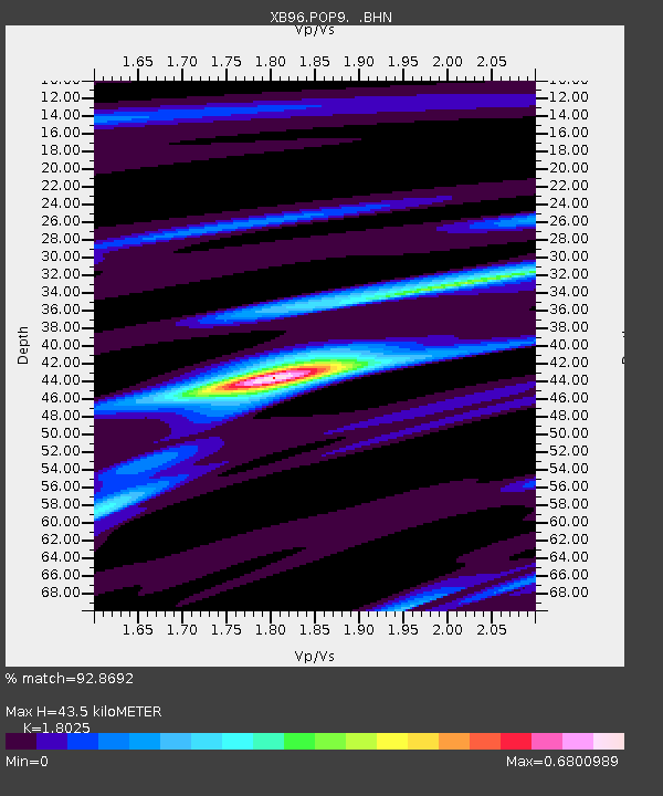
| Estimated Moho Depth: |
43.5 km |
| Estimated Crust Vp/Vs: |
1.80 |
| Assumed Crust Vp: |
6.622 km/s |
| Estimated Crust Vs: |
3.674 km/s |
| Estimated Crust Poisson's Ratio: |
0.28 |
|
| Radial Match: |
92.8692 % |
| Radial Bump: |
225 |
| Transverse Match: |
83.20296 % |
| Transverse Bump: |
400 |
| SOD ConfigId: |
6273 |
| Insert Time: |
2010-03-09 01:01:44.613 +0000 |
| GWidth: |
2.5 |
| Max Bumps: |
400 |
| Tol: |
0.001 |
|

Signal To Noise
| Channel | StoN | STA | LTA |
| XB:POP9: :BHN:19960905T08:25:26.128027Z | 2.2367215 | 3.2555994E-7 | 1.4555228E-7 |
| XB:POP9: :BHE:19960905T08:25:26.128027Z | 0.7252474 | 2.5816547E-7 | 3.5596887E-7 |
| XB:POP9: :BHZ:19960905T08:25:26.128027Z | 2.6691453 | 9.157253E-7 | 3.4307809E-7 |
| Arrivals |
| Ps | 5.5 SECOND |
| PpPs | 18 SECOND |
| PsPs/PpSs | 23 SECOND |


