
Station XB POP9 - XB.POP9
Network: XB96 - Abitibi Experiment
Nearby stations (2 deg radius)
| Station | Name | (Lat, Lon) | Start / End | Elevation |
| POP9 | XB.POP9 | (46.47, -78.40) | 1996-05-22 / 1996-12-31 | 0.0 m |
| Crust2 Type: | H2,early/mid Proter. shield, Finland, no seds. |
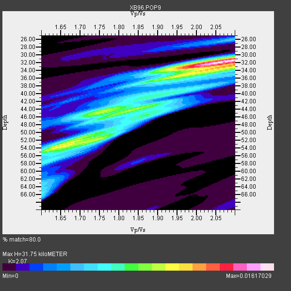
| Thickness Estimate: | 32 km |
| Thickness StdDev: | 8.5 km |
| Vp/Vs Estimate: | 2.07 |
| Vp/Vs StdDev: | 0.16 |
| Vs Estimate: | 3.199 km/s |
| Poisson's Ratio: | 0.35 |
| Peak Value: | 0.02 |
| Assumed Vp: | 6.622 km/s |
| Ps Weight: | 0.33333334 |
| PpPs Weight: | 0.33333334 |
| PsPs Weight: | 0.33333328 |
| Residual Complexity: | 0.765 |
| Nearby stations H: | +- |
| (2.0 deg) Vp/Vs: | +- |
7 with match > 90% ( 25.0 %) and 11 with match > 80% ( 39.285713 %) out of 28.
Download stack as xyz text file.
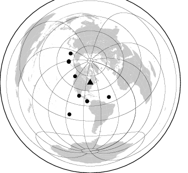
Azimuth Distribution of Events:
Prior Results for this Station
| Study | Thickness | Vp/Vs | Vp | Vs | Poissons Ratio | Extra |
| EARS | 32 km | 2.07 | 6.622 km/s | 3.199 km/s | 0.35 | |
| Crust2.0 | 45 km | 1.78 | 6.622 km/s | 3.729 km/s | 0.27 | H2,early/mid Proter. shield, Finland, no seds. |
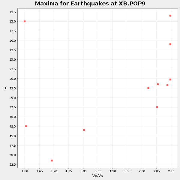
| Global Maxima | 32 km | 2.07 | 6.622 km/s | 3.199 km/s | 0.35 | amp=0.01617029 |
| Local Maxima 1 | 52 km | 1.69 | 6.622 km/s | 3.93 km/s | 0.23 | amp=0.009886 |
| Local Maxima 2 | 44 km | 1.76 | 6.622 km/s | 3.768 km/s | 0.26 | amp=0.008415092 |
| Local Maxima 3 | 33 km | 2.09 | 6.622 km/s | 3.176 km/s | 0.35 | amp=0.008103918 |
| Local Maxima 4 | 45 km | 1.87 | 6.622 km/s | 3.537 km/s | 0.30 | amp=0.0072453744 |
| Predicted Arrivals for vertical incidence (zero ray parameter) | |
| Ps | 5.13 SECOND |
| PpPs | 14.72 SECOND |
| PsPs/PpSs | 19.85 SECOND |
Events Processed for this Station
Download zip of receiver functions as SAC
Plot maxima for each earthquake.
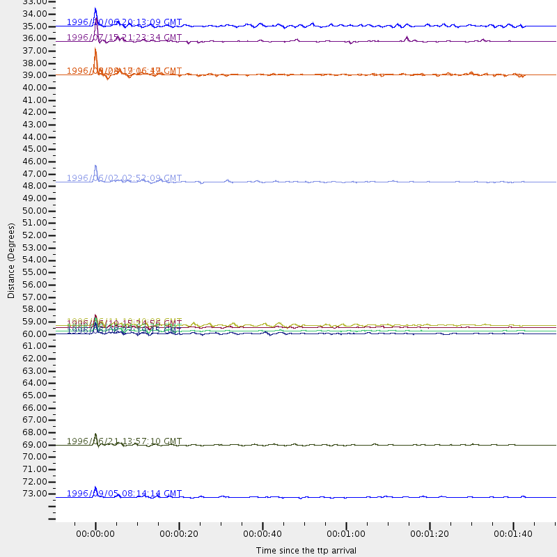
Events Used in the Stack
(11 events)| Radial Match | Distance | Baz | FERegion | Time | Lat/Lon | Depth | Magnitude |
| 98.71551 | 60.3 deg | 314.824 deg | Andreanof Islands, Aleutian Is. | 1996/06/10 04:03:35 GMT | (51.6, -177.6) | 33 km | 6.6 MB, 7.6 MS, 7.9 UNKNOWN, 7.4 MS |
| 98.24848 | 60.0 deg | 314.397 deg | Andreanof Islands, Aleutian Is. | 1996/06/10 15:24:56 GMT | (51.5, -176.8) | 26 km | 5.9 MB, 7.1 MS, 7.2 UNKNOWN, 6.9 MS |
| 95.89611 | 70.6 deg | 326.055 deg | Off East Coast Of Kamchatka | 1996/06/21 13:57:10 GMT | (51.6, 159.1) | 20 km | 6.0 MB, 6.6 MS, 7.0 UNKNOWN, 6.5 MS |
| 94.09741 | 46.9 deg | 127.498 deg | Northern Mid-Atlantic Ridge | 1996/06/02 02:52:09 GMT | (10.8, -42.3) | 10 km | 6.1 MB, 6.9 MS, 7.0 UNKNOWN, 6.8 MW |
| 92.8692 | 75.3 deg | 213.394 deg | Easter Island Region | 1996/09/05 08:14:14 GMT | (-22.1, -113.4) | 10 km | 6.2 MB, 7.0 MS, 7.0 UNKNOWN, 6.9 MW |
| 92.61881 | 34.3 deg | 220.478 deg | Guerrero, Mexico | 1996/07/15 21:23:34 GMT | (17.6, -101.0) | 18 km | 5.7 MB, 6.5 MS, 6.6 UNKNOWN, 6.2 ME |
| 91.89171 | 60.6 deg | 314.979 deg | Andreanof Islands, Aleutian Is. | 1996/06/08 23:19:15 GMT | (51.5, -178.1) | 33 km | 5.9 MB, 6.3 MS, 6.5 UNKNOWN, 6.1 MS |
| 89.93988 | 32.9 deg | 292.929 deg | Vancouver Island, Canada Region | 1996/10/06 20:13:09 GMT | (49.0, -127.9) | 10 km | 5.8 MB, 6.3 MS, 6.2 UNKNOWN, 6.2 MW |
| 85.19609 | 37.3 deg | 189.572 deg | Costa Rica | 1996/09/04 19:06:49 GMT | (9.4, -84.3) | 33 km | 5.8 MB, 5.9 MS, 6.2 UNKNOWN, 6.1 MW |
| 84.4015 | 37.3 deg | 189.651 deg | Costa Rica | 1996/08/28 17:16:17 GMT | (9.4, -84.3) | 33 km | 5.5 MB, 5.5 MS, 5.9 UNKNOWN |
| 80.4697 | 59.8 deg | 313.95 deg | Andreanof Islands, Aleutian Is. | 1996/06/11 10:40:08 GMT | (51.3, -176.3) | 33 km | 5.6 MB, 5.6 MS, 6.0 UNKNOWN, 5.5 MS |
Losers
(17 events)| Radial Match | Distance | Baz | FERegion | Time | Lat/Lon | Depth | Magnitude | Reason |
| 91.97322 | 88.1 deg | 330.616 deg | Eastern Honshu, Japan | 1996/08/10 18:54:11 GMT | (38.9, 140.6) | 10 km | 5.7 MB, 5.1 MS | |
| 79.25677 | 78.2 deg | 174.058 deg | Near Coast Of Central Chile | 1996/09/09 00:20:39 GMT | (-31.9, -71.6) | 39 km | 6.0 MB, 5.5 MS, 6.0 UNKNOWN, 5.8 ME | |
| 76.298386 | 50.1 deg | 329.284 deg | Near N. Coast Of Eastern Siberia | 1996/10/24 19:31:53 GMT | (67.0, -173.2) | 20 km | 6.0 MB, 5.9 MS, 6.1 UNKNOWN, 5.8 ME | |
| 75.69173 | 69.9 deg | 172.174 deg | Near Coast Of Northern Chile | 1996/07/03 16:48:27 GMT | (-23.4, -70.4) | 33 km | 5.3 MB, 5.4 MS, 5.8 UNKNOWN | |
| 74.269295 | 65.5 deg | 331.476 deg | Kamchatka Peninsula, Russia | 1996/07/07 10:49:59 GMT | (58.6, 157.8) | 10 km | 5.6 MB, 5.6 MS, 5.8 UNKNOWN, 5.8 MW | |
| 71.84819 | 91.0 deg | 328.857 deg | Near East Coast Of Honshu, Japan | 1996/09/11 02:37:14 GMT | (35.5, 140.9) | 55 km | 6.1 MB, 5.7 MS, 6.2 UNKNOWN, 6.1 MW | |
| 68.385635 | 91.5 deg | 9.638 deg | Southern Xinjiang, China | 1996/06/08 02:55:57 GMT | (41.7, 88.7) | 0.0 km | 5.9 MB, 4.3 MS | |
| 67.80384 | 35.4 deg | 192.01 deg | Nicaragua | 1996/09/18 17:34:20 GMT | (11.4, -85.5) | 193 km | 5.7 UNKNOWN, 5.3 MB, 5.5 MW | |
| 66.75651 | 55.3 deg | 212.07 deg | Central East Pacific Rise | 1996/08/23 21:56:06 GMT | (-4.1, -104.4) | 10 km | 5.0 MB, 5.6 MS | |
| 66.0078 | 56.7 deg | 312.605 deg | Fox Islands, Aleutian Islands | 1996/07/10 05:48:19 GMT | (52.2, -171.1) | 33 km | 5.9 ML, 5.4 MS, 5.3 MB | |
| 59.618896 | 88.1 deg | 330.623 deg | Eastern Honshu, Japan | 1996/08/10 18:12:17 GMT | (38.9, 140.5) | 10 km | 6.0 MB, 5.7 MS, 5.9 UNKNOWN, 5.9 MW | |
| 58.145897 | 60.7 deg | 314.954 deg | Andreanof Islands, Aleutian Is. | 1996/06/12 02:16:48 GMT | (51.4, -178.2) | 33 km | 5.5 MB, 5.3 MS, 5.7 UNKNOWN, 5.6 ML | |
| 57.758007 | 70.5 deg | 325.838 deg | Off East Coast Of Kamchatka | 1996/07/18 22:55:03 GMT | (51.5, 159.4) | 33 km | 5.5 MB, 5.2 MS | |
| 57.717552 | 64.3 deg | 54.245 deg | Adriatic Sea | 1996/09/05 20:44:09 GMT | (42.8, 17.9) | 10 km | 5.6 MB, 6.0 MS, 6.0 UNKNOWN, 5.7 MW | |
| 56.075275 | 60.7 deg | 315.05 deg | Andreanof Islands, Aleutian Is. | 1996/08/19 04:19:16 GMT | (51.5, -178.4) | 33 km | 5.7 MB, 5.6 MS, 6.0 UNKNOWN, 5.7 ML | |
| 54.988537 | 78.9 deg | 326.69 deg | Kuril Islands | 1996/10/02 11:24:48 GMT | (45.1, 151.2) | 33 km | 6.1 MB, 5.4 MS, 6.0 UNKNOWN, 6.0 MW | |
| 40.713963 | 72.7 deg | 330.549 deg | Sea Of Okhotsk | 1996/08/30 21:13:41 GMT | (52.3, 151.5) | 580 km | 5.5 UNKNOWN, 5.1 MB, 5.4 MW |
