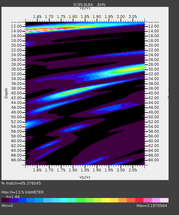
BLBA Blackbirch - Earthquake Result Viewer
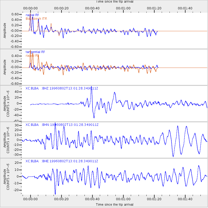
Earthquake location: Solomon Islands
Earthquake latitude/longitude: -10.8/161.4
Earthquake time(UTC): 1996/08/02 (215) 12:55:29 GMT
Earthquake Depth: 33 km
Earthquake Magnitude: 6.2 MB, 7.1 MS, 6.9 UNKNOWN, 6.9 MW
Earthquake Catalog/Contributor: WHDF/NEIC
Network: XC Southern Alps Passive Seismic Experiment
Station: BLBA Blackbirch
Lat/Lon: 41.71 S/173.88 E
Elevation: 253 m
Distance: 32.7 deg
Az: 162.642 deg
Baz: 336.949 deg
Ray Param: 0.078490034
Estimated Moho Depth: 13.5 km
Estimated Crust Vp/Vs: 1.64
Assumed Crust Vp: 6.289 km/s
Estimated Crust Vs: 3.834 km/s
Estimated Crust Poisson's Ratio: 0.20
Radial Match: 85.376045 %
Radial Bump: 400
Transverse Match: 66.49443 %
Transverse Bump: 400
SOD ConfigId: 6273
Insert Time: 2010-02-26 15:06:09.985 +0000
GWidth: 2.5
Max Bumps: 400
Tol: 0.001

Signal To Noise

ChannelStoNSTALTA
XC:BLBA: :BHN:19960802T13:01:28.349011Z1.29751311.2823922E-69.883462E-7
XC:BLBA: :BHE:19960802T13:01:28.349011Z1.01735518.6541314E-78.5065E-7
XC:BLBA: :BHZ:19960802T13:01:28.349011Z3.1803222.831828E-68.9042175E-7
Arrivals
Ps1.5 SECOND
PpPs5.2 SECOND
PsPs/PpSs6.7 SECOND