You are here: Home > Network List > XB97 - Seismic Experiment in Patagonia and Antarctica Stations List
> Station HAMB Puerto del Hambre, Patagonia > Earthquake Result Viewer
HAMB Puerto del Hambre, Patagonia - Earthquake Result Viewer
| Earthquake location: |
Kermadec Islands Region |
| Earthquake latitude/longitude: |
-28.7/-177.6 |
| Earthquake time(UTC): |
1997/09/20 (263) 16:11:32 GMT |
| Earthquake Depth: |
30 km |
| Earthquake Magnitude: |
6.1 MB, 7.0 MS, 7.2 UNKNOWN, 6.7 ME |
| Earthquake Catalog/Contributor: |
WHDF/NEIC |
|
| Network: |
XB Seismic Experiment in Patagonia and Antarctica |
| Station: |
HAMB Puerto del Hambre, Patagonia |
| Lat/Lon: |
53.61 S/70.93 W |
| Elevation: |
20 m |
|
| Distance: |
76.5 deg |
| Az: |
144.065 deg |
| Baz: |
239.935 deg |
| Ray Param: |
0.05089922 |
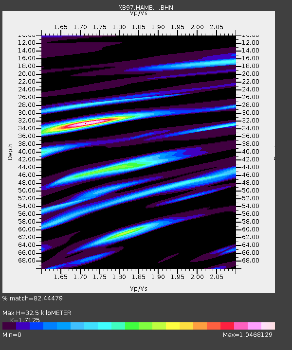
| Estimated Moho Depth: |
32.5 km |
| Estimated Crust Vp/Vs: |
1.71 |
| Assumed Crust Vp: |
6.079 km/s |
| Estimated Crust Vs: |
3.55 km/s |
| Estimated Crust Poisson's Ratio: |
0.24 |
|
| Radial Match: |
82.44479 % |
| Radial Bump: |
400 |
| Transverse Match: |
73.38504 % |
| Transverse Bump: |
400 |
| SOD ConfigId: |
6273 |
| Insert Time: |
2010-03-09 01:05:45.134 +0000 |
| GWidth: |
2.5 |
| Max Bumps: |
400 |
| Tol: |
0.001 |
|

Signal To Noise
| Channel | StoN | STA | LTA |
| XB:HAMB: :BHN:19970920T16:22:48.167017Z | 1.8349521 | 8.11049E-7 | 4.420001E-7 |
| XB:HAMB: :BHE:19970920T16:22:48.167017Z | 3.1556442 | 1.4137187E-6 | 4.4799688E-7 |
| XB:HAMB: :BHZ:19970920T16:22:48.167017Z | 6.2661324 | 2.9556063E-6 | 4.7167953E-7 |
| Arrivals |
| Ps | 3.9 SECOND |
| PpPs | 14 SECOND |
| PsPs/PpSs | 18 SECOND |


