
Station XB HAMB - Puerto del Hambre, Patagonia
Network: XB97 - Seismic Experiment in Patagonia and Antarctica
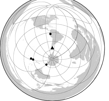
Nearby stations (2 deg radius)
| Station | Name | (Lat, Lon) | Start / End | Elevation |
| HAMB | Puerto del Hambre, Patagonia | (-53.61, -70.93) | 1997-01-11 / 2000-12-31 | 20 m |
| Crust2 Type: | L7,continental arc, Cordilleras, 5.0 km seds. |
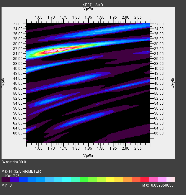
| Thickness Estimate: | 32 km |
| Thickness StdDev: | 1.8 km |
| Vp/Vs Estimate: | 1.73 |
| Vp/Vs StdDev: | 0.06 |
| Vs Estimate: | 3.524 km/s |
| Poisson's Ratio: | 0.25 |
| Peak Value: | 0.06 |
| Assumed Vp: | 6.079 km/s |
| Ps Weight: | 0.33333334 |
| PpPs Weight: | 0.33333334 |
| PsPs Weight: | 0.33333328 |
| Residual Complexity: | 0.442 |
| Nearby stations H: | +- |
| (2.0 deg) Vp/Vs: | +- |
2 with match > 90% ( 11.111111 %) and 4 with match > 80% ( 22.222221 %) out of 18.
Download stack as xyz text file.
Azimuth Distribution of Events:
Prior Results for this Station
| Study | Thickness | Vp/Vs | Vp | Vs | Poissons Ratio | Extra |
| EARS | 32 km | 1.73 | 6.079 km/s | 3.524 km/s | 0.25 | |
| Crust2.0 | 26 km | 1.78 | 6.079 km/s | 3.411 km/s | 0.27 | L7,continental arc, Cordilleras, 5.0 km seds. |
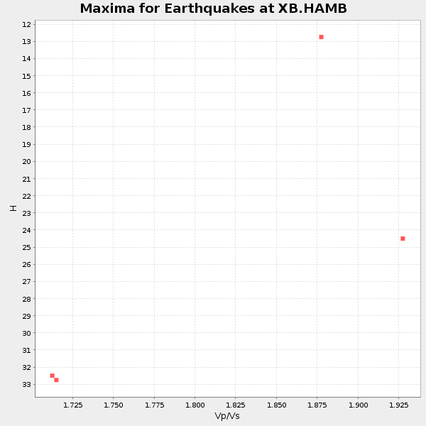
| Global Maxima | 32 km | 1.73 | 6.079 km/s | 3.524 km/s | 0.25 | amp=0.059650656 |
| Local Maxima 1 | 24 km | 1.92 | 6.079 km/s | 3.166 km/s | 0.31 | amp=0.015725495 |
| Local Maxima 2 | 40 km | 1.62 | 6.079 km/s | 3.753 km/s | 0.19 | amp=0.014835989 |
| Local Maxima 3 | 44 km | 1.81 | 6.079 km/s | 3.363 km/s | 0.28 | amp=0.014818876 |
| Local Maxima 4 | 35 km | 1.64 | 6.079 km/s | 3.707 km/s | 0.20 | amp=0.013580165 |
| Predicted Arrivals for vertical incidence (zero ray parameter) | |
| Ps | 3.88 SECOND |
| PpPs | 14.57 SECOND |
| PsPs/PpSs | 18.44 SECOND |
Events Processed for this Station
Download zip of receiver functions as SAC
Plot maxima for each earthquake.
Events Used in the Stack
(4 events)| Radial Match | Distance | Baz | FERegion | Time | Lat/Lon | Depth | Magnitude |
| 90.42408 | 49.3 deg | 352.43 deg | Northern Peru | 1997/10/28 06:15:17 GMT | (-4.4, -76.7) | 112 km | 6.6 MB, 6.3 MS, 7.2 UNKNOWN, 6.6 ME |
| 90.233376 | 59.6 deg | 200.17 deg | Balleny Islands Region | 1998/03/25 03:12:25 GMT | (-62.9, 149.5) | 10 km | 6.6 MB, 8.0 MS, 8.3 UNKNOWN, 8.1 MW |
| 89.39851 | 81.4 deg | 244.466 deg | South Of Fiji Islands | 1997/10/14 09:53:18 GMT | (-22.1, -176.8) | 167 km | 6.7 MB, 7.7 UNKNOWN, 7.4 ME |
| 82.44479 | 76.5 deg | 239.935 deg | Kermadec Islands Region | 1997/09/20 16:11:32 GMT | (-28.7, -177.6) | 30 km | 6.1 MB, 7.0 MS, 7.2 UNKNOWN, 6.7 ME |
Losers
(14 events)| Radial Match | Distance | Baz | FERegion | Time | Lat/Lon | Depth | Magnitude | Reason |
| 99.26317 | 78.8 deg | 325.067 deg | Off Coast Of Jalisco, Mexico | 1997/05/01 11:37:36 GMT | (19.0, -107.3) | 33 km | 6.1 MB, 6.8 MS, 7.1 UNKNOWN, 7.1 ME | |
| 97.77045 | 68.6 deg | 133.323 deg | Prince Edward Islands Region | 1997/04/28 12:07:37 GMT | (-42.5, 42.7) | 10 km | 5.7 MB, 6.3 MS, 6.8 UNKNOWN, 6.5 MW | |
| 72.089874 | 80.3 deg | 238.182 deg | South Of Fiji Islands | 1997/09/04 04:23:37 GMT | (-26.6, 178.3) | 625 km | 6.3 MB, 6.8 UNKNOWN, 6.5 ME | |
| 70.36929 | 65.0 deg | 10.878 deg | Windward Islands | 1997/04/22 09:31:23 GMT | (11.1, -60.9) | 5.0 km | 6.0 MB, 6.5 MS, 6.7 UNKNOWN, 6.1 ME | |
| 70.0807 | 35.3 deg | 2.312 deg | Northern Chile | 1997/04/01 18:33:32 GMT | (-18.3, -69.5) | 114 km | 5.9 MB, 6.2 UNKNOWN, 6.1 MW | |
| 69.031525 | 31.4 deg | 289.373 deg | Southern East Pacific Rise | 1997/06/10 21:53:55 GMT | (-35.8, -108.1) | 10 km | 5.8 MB, 6.1 MS, 6.5 UNKNOWN, 5.8 MS | |
| 65.28076 | 33.4 deg | 4.382 deg | Chile-Bolivia Border Region | 1997/12/09 14:23:45 GMT | (-20.2, -68.4) | 133 km | 5.7 MB, 5.7 UNKNOWN, 5.7 MW | |
| 62.57632 | 31.2 deg | 4.435 deg | Northern Chile | 1997/09/28 23:13:13 GMT | (-22.4, -68.4) | 107 km | 5.7 MB, 5.6 UNKNOWN, 5.6 MW | |
| 61.975727 | 97.2 deg | 235.578 deg | Vanuatu Islands | 1997/04/23 03:47:18 GMT | (-13.6, 166.4) | 33 km | 5.5 MB, 6.0 MS, 6.1 UNKNOWN, 5.9 MW | |
| 61.548756 | 58.2 deg | 353.468 deg | Colombia | 1997/02/19 18:25:12 GMT | (4.6, -76.5) | 101 km | 5.5 MB, 5.8 UNKNOWN, 5.7 MW | |
| 59.33007 | 35.2 deg | 2.609 deg | Northern Chile | 1997/04/01 18:42:14 GMT | (-18.4, -69.3) | 116 km | 5.8 MB, 6.2 UNKNOWN, 6.2 MW | |
| 57.96135 | 74.6 deg | 238.404 deg | Kermadec Islands Region | 1997/03/11 05:25:57 GMT | (-31.1, -177.7) | 10 km | 5.6 MB, 6.2 MS, 6.2 UNKNOWN, 6.1 MW | |
| 53.239357 | 80.3 deg | 242.814 deg | South Of Fiji Islands | 1997/06/11 09:29:23 GMT | (-24.0, -177.5) | 164 km | 5.9 UNKNOWN, 5.4 MB, 5.5 MB | |
| 18.990171 | 49.9 deg | 210.729 deg | Balleny Islands Region | 1997/09/23 17:51:23 GMT | (-65.5, 178.8) | 10 km | 5.9 MS, 5.0 MB |
