You are here: Home > Network List > XB97 - Seismic Experiment in Patagonia and Antarctica Stations List
> Station HAMB Puerto del Hambre, Patagonia > Earthquake Result Viewer
HAMB Puerto del Hambre, Patagonia - Earthquake Result Viewer
| Earthquake location: |
Balleny Islands Region |
| Earthquake latitude/longitude: |
-62.9/149.5 |
| Earthquake time(UTC): |
1998/03/25 (084) 03:12:25 GMT |
| Earthquake Depth: |
10 km |
| Earthquake Magnitude: |
6.6 MB, 8.0 MS, 8.3 UNKNOWN, 8.1 MW |
| Earthquake Catalog/Contributor: |
WHDF/NEIC |
|
| Network: |
XB Seismic Experiment in Patagonia and Antarctica |
| Station: |
HAMB Puerto del Hambre, Patagonia |
| Lat/Lon: |
53.61 S/70.93 W |
| Elevation: |
20 m |
|
| Distance: |
59.6 deg |
| Az: |
153.369 deg |
| Baz: |
200.17 deg |
| Ray Param: |
0.062080994 |
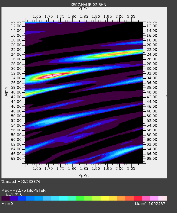
| Estimated Moho Depth: |
32.75 km |
| Estimated Crust Vp/Vs: |
1.72 |
| Assumed Crust Vp: |
6.079 km/s |
| Estimated Crust Vs: |
3.545 km/s |
| Estimated Crust Poisson's Ratio: |
0.24 |
|
| Radial Match: |
90.233376 % |
| Radial Bump: |
400 |
| Transverse Match: |
69.6239 % |
| Transverse Bump: |
400 |
| SOD ConfigId: |
6273 |
| Insert Time: |
2010-03-09 01:05:54.272 +0000 |
| GWidth: |
2.5 |
| Max Bumps: |
400 |
| Tol: |
0.001 |
|

Signal To Noise
| Channel | StoN | STA | LTA |
| XB:HAMB:02:BHN:19980325T03:21:57.809021Z | 1.8903676 | 1.2034329E-6 | 6.3661315E-7 |
| XB:HAMB:02:BHE:19980325T03:21:57.809021Z | 1.6024035 | 8.77686E-7 | 5.477309E-7 |
| XB:HAMB:02:BHZ:19980325T03:21:57.809021Z | 2.582488 | 2.918355E-6 | 1.1300555E-6 |
| Arrivals |
| Ps | 4.0 SECOND |
| PpPs | 14 SECOND |
| PsPs/PpSs | 18 SECOND |


