You are here: Home > Network List > SP - South Carolina Earth Physics Project Stations List
> Station DFORK Dutch Fork High School, Richland County, SC USA > Earthquake Result Viewer
DFORK Dutch Fork High School, Richland County, SC USA - Earthquake Result Viewer
| Earthquake location: |
Queen Charlotte Islands Region |
| Earthquake latitude/longitude: |
52.6/-132.2 |
| Earthquake time(UTC): |
2001/10/12 (285) 05:02:34 GMT |
| Earthquake Depth: |
20 km |
| Earthquake Magnitude: |
5.6 MB, 5.8 MS, 6.2 MW, 6.1 MW |
| Earthquake Catalog/Contributor: |
WHDF/NEIC |
|
| Network: |
SP South Carolina Earth Physics Project |
| Station: |
DFORK Dutch Fork High School, Richland County, SC USA |
| Lat/Lon: |
34.15 N/81.20 W |
| Elevation: |
91 m |
|
| Distance: |
40.4 deg |
| Az: |
96.472 deg |
| Baz: |
313.086 deg |
| Ray Param: |
0.074377835 |
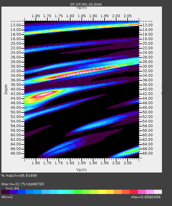
| Estimated Moho Depth: |
32.75 km |
| Estimated Crust Vp/Vs: |
1.84 |
| Assumed Crust Vp: |
6.419 km/s |
| Estimated Crust Vs: |
3.489 km/s |
| Estimated Crust Poisson's Ratio: |
0.29 |
|
| Radial Match: |
89.93499 % |
| Radial Bump: |
400 |
| Transverse Match: |
48.23622 % |
| Transverse Bump: |
400 |
| SOD ConfigId: |
2277 |
| Insert Time: |
2010-02-25 17:49:55.937 +0000 |
| GWidth: |
2.5 |
| Max Bumps: |
400 |
| Tol: |
0.001 |
|
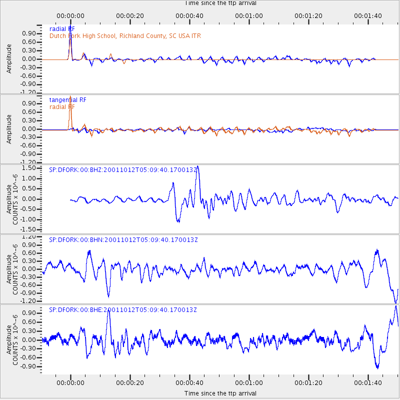
Signal To Noise
| Channel | StoN | STA | LTA |
| SP:DFORK:00:BHN:20011012T05:09:40.170013Z | 1.6974708 | 2.0064435E-7 | 1.18201946E-7 |
| SP:DFORK:00:BHE:20011012T05:09:40.170013Z | 1.7533809 | 2.4661614E-7 | 1.4065176E-7 |
| SP:DFORK:00:BHZ:20011012T05:09:40.170013Z | 3.6622515 | 3.1814614E-7 | 8.687174E-8 |
| Arrivals |
| Ps | 4.6 SECOND |
| PpPs | 14 SECOND |
| PsPs/PpSs | 18 SECOND |


