
Station SP DFORK - Dutch Fork High School, Richland County, SC USA
Network: SP - South Carolina Earth Physics Project
Nearby stations (2 deg radius)
| Station | Name | (Lat, Lon) | Start / End | Elevation |
| DFORK | Dutch Fork High School, Richland County, SC USA | (34.15, -81.20) | 2001-09-17 / 2499-01-01 | 91 m |
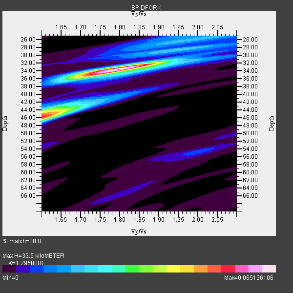
| Crust2 Type: | Q2,orogen/39km no ice, Appalachians, North Andes, 0.5 km seds. |
| Thickness Estimate: | 34 km |
| Thickness StdDev: | 4.4 km |
| Vp/Vs Estimate: | 1.80 |
| Vp/Vs StdDev: | 0.07 |
| Vs Estimate: | 3.576 km/s |
| Poisson's Ratio: | 0.27 |
| Peak Value: | 0.07 |
| Assumed Vp: | 6.419 km/s |
| Ps Weight: | 0.33333334 |
| PpPs Weight: | 0.33333334 |
| PsPs Weight: | 0.33333328 |
| Residual Complexity: | 0.574 |
| Nearby stations H: | +- |
| (2.0 deg) Vp/Vs: | +- |
2 with match > 90% ( 33.333332 %) and 5 with match > 80% ( 83.333336 %) out of 6.
Download stack as xyz text file.
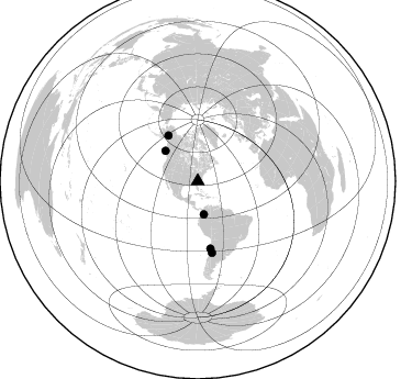
Azimuth Distribution of Events:
Prior Results for this Station
| Study | Thickness | Vp/Vs | Vp | Vs | Poissons Ratio | Extra |
| EARS | 34 km | 1.80 | 6.419 km/s | 3.576 km/s | 0.27 | |
| Crust2.0 | 39 km | 1.75 | 6.419 km/s | 3.659 km/s | 0.26 | Q2,orogen/39km no ice, Appalachians, North Andes, 0.5 km seds. |
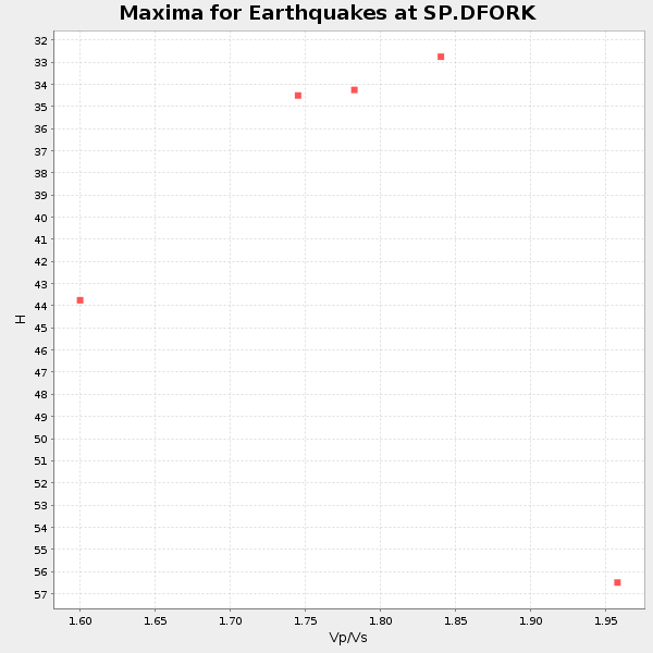
| Global Maxima | 34 km | 1.80 | 6.419 km/s | 3.576 km/s | 0.27 | amp=0.065126106 |
| Local Maxima 1 | 46 km | 1.60 | 6.419 km/s | 4.012 km/s | 0.18 | amp=0.053911723 |
| Local Maxima 2 | 44 km | 1.61 | 6.419 km/s | 4.0 km/s | 0.18 | amp=0.028394451 |
| Local Maxima 3 | 27 km | 1.92 | 6.419 km/s | 3.343 km/s | 0.31 | amp=0.014805167 |
| Local Maxima 4 | 28 km | 2.06 | 6.419 km/s | 3.12 km/s | 0.35 | amp=0.01067057 |
| Predicted Arrivals for vertical incidence (zero ray parameter) | |
| Ps | 4.15 SECOND |
| PpPs | 14.59 SECOND |
| PsPs/PpSs | 18.74 SECOND |
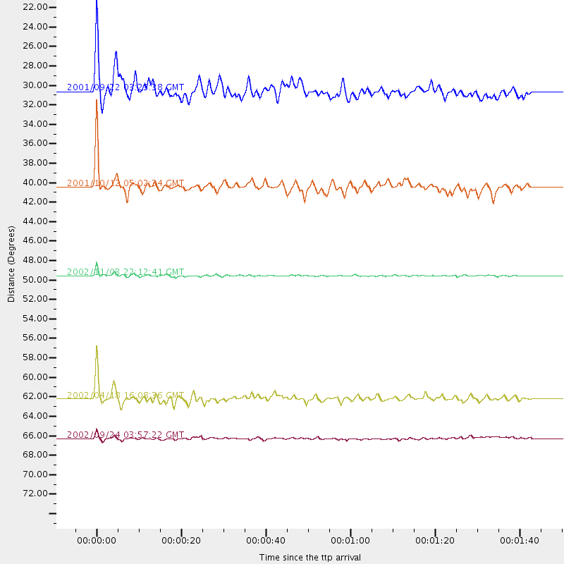
Events Processed for this Station
Download zip of receiver functions as SAC
Plot maxima for each earthquake.
Events Used in the Stack
(5 events)| Radial Match | Distance | Baz | FERegion | Time | Lat/Lon | Depth | Magnitude |
| 97.18199 | 49.5 deg | 327.347 deg | Central Alaska | 2002/11/03 22:12:41 GMT | (63.5, -147.4) | 4.9 km | 7.0 MB, 8.5 MS, 7.9 MW |
| 91.23393 | 62.2 deg | 169.341 deg | Near Coast Of Northern Chile | 2002/04/18 16:08:36 GMT | (-27.5, -70.6) | 62 km | 6.2 MB, 6.7 MW, 6.6 MW |
| 89.93499 | 40.4 deg | 313.086 deg | Queen Charlotte Islands Region | 2001/10/12 05:02:34 GMT | (52.6, -132.2) | 20 km | 5.6 MB, 5.8 MS, 6.2 MW, 6.1 MW |
| 84.25689 | 66.3 deg | 168.818 deg | San Juan Province, Argentina | 2002/09/24 03:57:22 GMT | (-31.5, -69.2) | 120 km | 6.2 MB, 6.4 MW, 6.3 MW |
| 82.75987 | 30.5 deg | 169.678 deg | Colombia | 2001/09/22 03:23:38 GMT | (3.9, -76.0) | 179 km | 6.0 MB, 6.0 MW, 6.0 MW |
Losers
(1 events)| Radial Match | Distance | Baz | FERegion | Time | Lat/Lon | Depth | Magnitude | Reason |
| 80.84884 | 64.2 deg | 165.987 deg | Catamarca Province, Argentina | 2002/05/28 04:04:22 GMT | (-28.9, -66.8) | 22 km | 6.0 MB, 5.7 MS, 6.0 MW, 5.9 MW |
