You are here: Home > Network List > SP - South Carolina Earth Physics Project Stations List
> Station DFORK Dutch Fork High School, Richland County, SC USA > Earthquake Result Viewer
DFORK Dutch Fork High School, Richland County, SC USA - Earthquake Result Viewer
| Earthquake location: |
Near Coast Of Northern Chile |
| Earthquake latitude/longitude: |
-27.5/-70.6 |
| Earthquake time(UTC): |
2002/04/18 (108) 16:08:36 GMT |
| Earthquake Depth: |
62 km |
| Earthquake Magnitude: |
6.2 MB, 6.7 MW, 6.6 MW |
| Earthquake Catalog/Contributor: |
WHDF/NEIC |
|
| Network: |
SP South Carolina Earth Physics Project |
| Station: |
DFORK Dutch Fork High School, Richland County, SC USA |
| Lat/Lon: |
34.15 N/81.20 W |
| Elevation: |
91 m |
|
| Distance: |
62.2 deg |
| Az: |
350.054 deg |
| Baz: |
169.341 deg |
| Ray Param: |
0.060251284 |
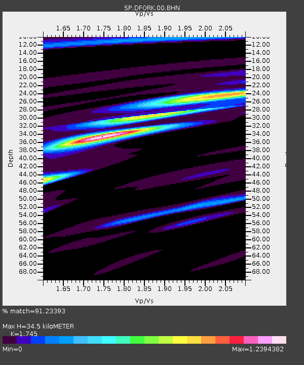
| Estimated Moho Depth: |
34.5 km |
| Estimated Crust Vp/Vs: |
1.75 |
| Assumed Crust Vp: |
6.419 km/s |
| Estimated Crust Vs: |
3.679 km/s |
| Estimated Crust Poisson's Ratio: |
0.26 |
|
| Radial Match: |
91.23393 % |
| Radial Bump: |
400 |
| Transverse Match: |
66.77799 % |
| Transverse Bump: |
400 |
| SOD ConfigId: |
2277 |
| Insert Time: |
2010-02-25 17:49:56.730 +0000 |
| GWidth: |
2.5 |
| Max Bumps: |
400 |
| Tol: |
0.001 |
|
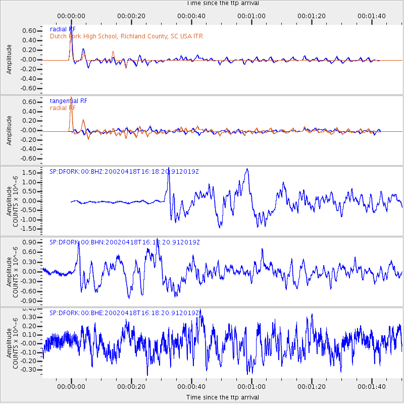
Signal To Noise
| Channel | StoN | STA | LTA |
| SP:DFORK:00:BHN:20020418T16:18:20.912019Z | 3.7130387 | 3.655228E-7 | 9.844304E-8 |
| SP:DFORK:00:BHE:20020418T16:18:20.912019Z | 0.65306145 | 8.74108E-8 | 1.3384773E-7 |
| SP:DFORK:00:BHZ:20020418T16:18:20.912019Z | 18.182682 | 6.9366314E-7 | 3.814966E-8 |
| Arrivals |
| Ps | 4.2 SECOND |
| PpPs | 14 SECOND |
| PsPs/PpSs | 18 SECOND |


