You are here: Home > Network List > SP - South Carolina Earth Physics Project Stations List
> Station DFORK Dutch Fork High School, Richland County, SC USA > Earthquake Result Viewer
DFORK Dutch Fork High School, Richland County, SC USA - Earthquake Result Viewer
| Earthquake location: |
Central Alaska |
| Earthquake latitude/longitude: |
63.5/-147.4 |
| Earthquake time(UTC): |
2002/11/03 (307) 22:12:41 GMT |
| Earthquake Depth: |
4.9 km |
| Earthquake Magnitude: |
7.0 MB, 8.5 MS, 7.9 MW |
| Earthquake Catalog/Contributor: |
WHDF/NEIC |
|
| Network: |
SP South Carolina Earth Physics Project |
| Station: |
DFORK Dutch Fork High School, Richland County, SC USA |
| Lat/Lon: |
34.15 N/81.20 W |
| Elevation: |
91 m |
|
| Distance: |
49.5 deg |
| Az: |
93.624 deg |
| Baz: |
327.347 deg |
| Ray Param: |
0.06866617 |
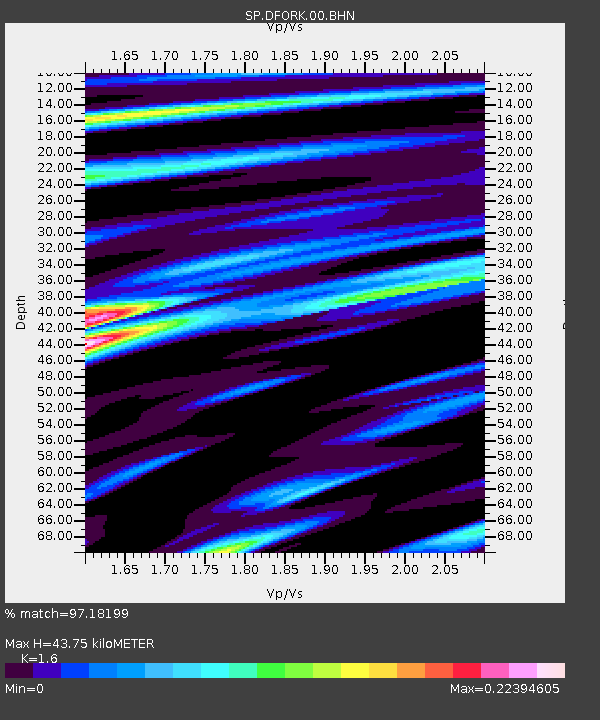
| Estimated Moho Depth: |
43.75 km |
| Estimated Crust Vp/Vs: |
1.60 |
| Assumed Crust Vp: |
6.419 km/s |
| Estimated Crust Vs: |
4.012 km/s |
| Estimated Crust Poisson's Ratio: |
0.18 |
|
| Radial Match: |
97.18199 % |
| Radial Bump: |
365 |
| Transverse Match: |
95.92433 % |
| Transverse Bump: |
400 |
| SOD ConfigId: |
2277 |
| Insert Time: |
2010-02-25 17:50:00.250 +0000 |
| GWidth: |
2.5 |
| Max Bumps: |
400 |
| Tol: |
0.001 |
|

Signal To Noise
| Channel | StoN | STA | LTA |
| SP:DFORK:00:BHN:20021103T22:21:01.509003Z | 6.707721 | 5.8703723E-8 | 8.751664E-9 |
| SP:DFORK:00:BHE:20021103T22:21:01.509003Z | 3.3489168 | 2.2001193E-7 | 6.569645E-8 |
| SP:DFORK:00:BHZ:20021103T22:21:01.509003Z | 9.169766 | 1.246137E-6 | 1.3589626E-7 |
| Arrivals |
| Ps | 4.4 SECOND |
| PpPs | 17 SECOND |
| PsPs/PpSs | 21 SECOND |


