You are here: Home > Network List > SP - South Carolina Earth Physics Project Stations List
> Station GREEN Greenwood High School, Greenwood County, SC USA > Earthquake Result Viewer
GREEN Greenwood High School, Greenwood County, SC USA - Earthquake Result Viewer
| Earthquake location: |
Western Brazil |
| Earthquake latitude/longitude: |
-7.6/-71.7 |
| Earthquake time(UTC): |
2003/06/20 (171) 06:19:38 GMT |
| Earthquake Depth: |
558 km |
| Earthquake Magnitude: |
6.4 MB, 7.1 MW, 7.0 MW |
| Earthquake Catalog/Contributor: |
WHDF/NEIC |
|
| Network: |
SP South Carolina Earth Physics Project |
| Station: |
GREEN Greenwood High School, Greenwood County, SC USA |
| Lat/Lon: |
34.23 N/82.17 W |
| Elevation: |
183 m |
|
| Distance: |
42.8 deg |
| Az: |
347.211 deg |
| Baz: |
164.642 deg |
| Ray Param: |
0.07018532 |
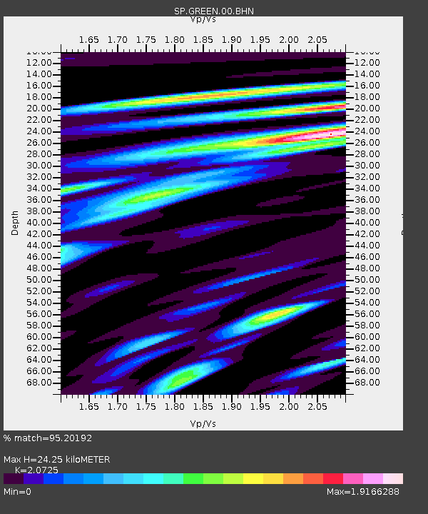
| Estimated Moho Depth: |
24.25 km |
| Estimated Crust Vp/Vs: |
2.07 |
| Assumed Crust Vp: |
6.35 km/s |
| Estimated Crust Vs: |
3.064 km/s |
| Estimated Crust Poisson's Ratio: |
0.35 |
|
| Radial Match: |
95.20192 % |
| Radial Bump: |
400 |
| Transverse Match: |
77.48844 % |
| Transverse Bump: |
400 |
| SOD ConfigId: |
2277 |
| Insert Time: |
2010-02-25 17:50:04.705 +0000 |
| GWidth: |
2.5 |
| Max Bumps: |
400 |
| Tol: |
0.001 |
|

Signal To Noise
| Channel | StoN | STA | LTA |
| SP:GREEN:00:BHN:20030620T06:26:17.175015Z | 54.055218 | 5.1709285E-6 | 9.566011E-8 |
| SP:GREEN:00:BHE:20030620T06:26:17.175015Z | 3.247816 | 4.567666E-7 | 1.4063806E-7 |
| SP:GREEN:00:BHZ:20030620T06:26:17.175015Z | 59.182602 | 4.1503095E-6 | 7.0127186E-8 |
| Arrivals |
| Ps | 4.3 SECOND |
| PpPs | 11 SECOND |
| PsPs/PpSs | 15 SECOND |


