
Station SP GREEN - Greenwood High School, Greenwood County, SC USA
Network: SP - South Carolina Earth Physics Project
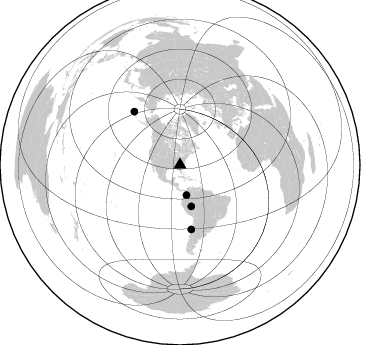
Nearby stations (2 deg radius)
| Station | Name | (Lat, Lon) | Start / End | Elevation |
| GREEN | Greenwood High School, Greenwood County, SC USA | (34.23, -82.17) | 2001-09-11 / 2499-01-01 | 183 m |
| Crust2 Type: | P6,orogen/43km, Orogen, 0.5 km seds. |
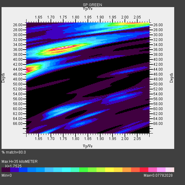
| Thickness Estimate: | 35 km |
| Thickness StdDev: | 6.8 km |
| Vp/Vs Estimate: | 1.75 |
| Vp/Vs StdDev: | 0.16 |
| Vs Estimate: | 3.623 km/s |
| Poisson's Ratio: | 0.26 |
| Peak Value: | 0.08 |
| Assumed Vp: | 6.35 km/s |
| Ps Weight: | 0.33333334 |
| PpPs Weight: | 0.33333334 |
| PsPs Weight: | 0.33333328 |
| Residual Complexity: | 0.693 |
| Nearby stations H: | +- |
| (2.0 deg) Vp/Vs: | +- |
3 with match > 90% ( 75.0 %) and 4 with match > 80% ( 100.0 %) out of 4.
Download stack as xyz text file.
Azimuth Distribution of Events:
Prior Results for this Station
| Study | Thickness | Vp/Vs | Vp | Vs | Poissons Ratio | Extra |
| EARS | 35 km | 1.75 | 6.35 km/s | 3.623 km/s | 0.26 | |
| Crust2.0 | 43 km | 1.76 | 6.35 km/s | 3.609 km/s | 0.26 | P6,orogen/43km, Orogen, 0.5 km seds. |
| Global Maxima | 35 km | 1.75 | 6.35 km/s | 3.623 km/s | 0.26 | amp=0.07782028 |
| Local Maxima 1 | 45 km | 1.60 | 6.35 km/s | 3.969 km/s | 0.18 | amp=0.065588295 |
| Local Maxima 2 | 25 km | 2.03 | 6.35 km/s | 3.124 km/s | 0.34 | amp=0.05134238 |
| Local Maxima 3 | 37 km | 1.74 | 6.35 km/s | 3.66 km/s | 0.25 | amp=0.036380477 |
| Local Maxima 4 | 60 km | 1.77 | 6.35 km/s | 3.588 km/s | 0.27 | amp=0.026503654 |
| Predicted Arrivals for vertical incidence (zero ray parameter) | |
| Ps | 4.15 SECOND |
| PpPs | 15.17 SECOND |
| PsPs/PpSs | 19.32 SECOND |
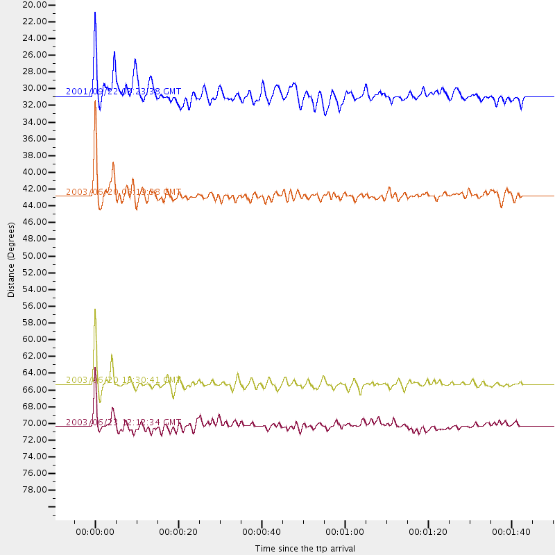
Events Processed for this Station
Download zip of receiver functions as SAC
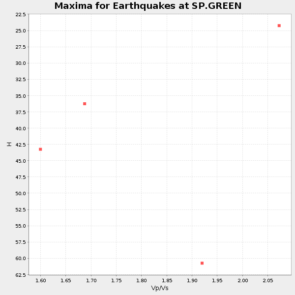
Plot maxima for each earthquake.
Events Used in the Stack
(4 events)| Radial Match | Distance | Baz | FERegion | Time | Lat/Lon | Depth | Magnitude |
| 96.64811 | 65.3 deg | 170.002 deg | Near Coast Of Central Chile | 2003/06/20 13:30:41 GMT | (-30.6, -71.6) | 33 km | 6.4 MB, 6.8 MS, 6.8 MW, 6.7 MW |
| 95.20192 | 42.8 deg | 164.642 deg | Western Brazil | 2003/06/20 06:19:38 GMT | (-7.6, -71.7) | 558 km | 6.4 MB, 7.1 MW, 7.0 MW |
| 91.44994 | 70.3 deg | 319.264 deg | Rat Islands, Aleutian Islands | 2003/06/23 12:12:34 GMT | (51.4, 176.8) | 20 km | 6.3 MB, 7.0 MS, 6.9 MW, 6.8 MW |
| 84.88309 | 30.8 deg | 167.822 deg | Colombia | 2001/09/22 03:23:38 GMT | (3.9, -76.0) | 179 km | 6.0 MB, 6.0 MW, 6.0 MW |
Losers
(0 events)| Radial Match | Distance | Baz | FERegion | Time | Lat/Lon | Depth | Magnitude | Reason |
