You are here: Home > Network List > XT94 - Micronesia Seismic Network Stations List
> Station PNI Pohnpei > Earthquake Result Viewer
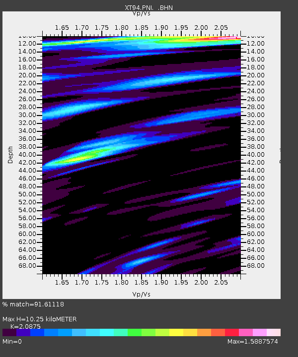
PNI Pohnpei - Earthquake Result Viewer
| Earthquake location: |
Banda Sea |
| Earthquake latitude/longitude: |
-6.9/129.2 |
| Earthquake time(UTC): |
1995/12/25 (359) 04:43:24 GMT |
| Earthquake Depth: |
150 km |
| Earthquake Magnitude: |
6.2 MB, 7.1 UNKNOWN, 7.1 MW |
| Earthquake Catalog/Contributor: |
WHDF/NEIC |
|
| Network: |
XT Micronesia Seismic Network |
| Station: |
PNI Pohnpei |
| Lat/Lon: |
7.01 N/158.15 E |
| Elevation: |
1.0 m |
|
| Distance: |
32.1 deg |
| Az: |
64.965 deg |
| Baz: |
244.981 deg |
| Ray Param: |
0.0783847 |
| Estimated Moho Depth: |
10.25 km |
| Estimated Crust Vp/Vs: |
2.09 |
| Assumed Crust Vp: |
4.24 km/s |
| Estimated Crust Vs: |
2.031 km/s |
| Estimated Crust Poisson's Ratio: |
0.35 |
|
| Radial Match: |
91.61118 % |
| Radial Bump: |
359 |
| Transverse Match: |
81.190704 % |
| Transverse Bump: |
400 |
| SOD ConfigId: |
6273 |
| Insert Time: |
2010-03-09 01:25:14.442 +0000 |
| GWidth: |
2.5 |
| Max Bumps: |
400 |
| Tol: |
0.001 |
|

Signal To Noise
| Channel | StoN | STA | LTA |
| XT:PNI: :BHN:19951225T04:49:07.165991Z | 1.2043076 | 1.24933E-6 | 1.0373845E-6 |
| XT:PNI: :BHE:19951225T04:49:07.165991Z | 2.849443 | 1.9854579E-6 | 6.9678805E-7 |
| XT:PNI: :BHZ:19951225T04:49:07.165991Z | 3.4344614 | 1.7888118E-6 | 5.2084204E-7 |
| Arrivals |
| Ps | 2.7 SECOND |
| PpPs | 7.3 SECOND |
| PsPs/PpSs | 10.0 SECOND |


