
Station XT PNI - Pohnpei
Network: XT94 - Micronesia Seismic Network
Nearby stations (2 deg radius)
| Station | Name | (Lat, Lon) | Start / End | Elevation |
| PNI | Pohnpei | (7.01, 158.15) | 1995-07-10 / 1996-12-31 | 1.0 m |
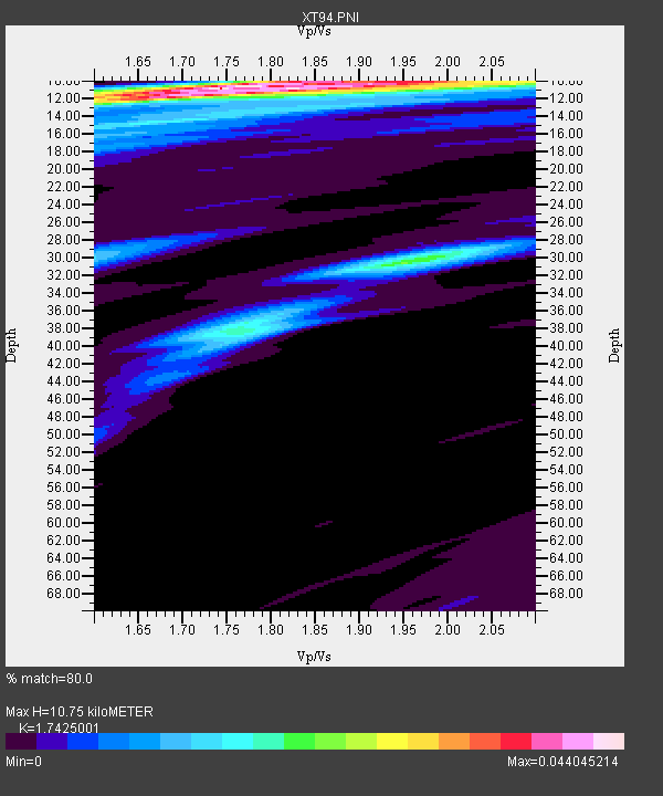
| Crust2 Type: | A0,normal oceanic, 0.07 km seds. |
| Thickness Estimate: | 11 km |
| Thickness StdDev: | 5.8 km |
| Vp/Vs Estimate: | 1.74 |
| Vp/Vs StdDev: | 0.11 |
| Vs Estimate: | 2.433 km/s |
| Poisson's Ratio: | 0.25 |
| Peak Value: | 0.04 |
| Assumed Vp: | 4.24 km/s |
| Ps Weight: | 0.33333334 |
| PpPs Weight: | 0.33333334 |
| PsPs Weight: | 0.33333328 |
| Residual Complexity: | 0.639 |
| Nearby stations H: | +- |
| (2.0 deg) Vp/Vs: | +- |
5 with match > 90% ( 21.73913 %) and 8 with match > 80% ( 34.782608 %) out of 23.
Download stack as xyz text file.
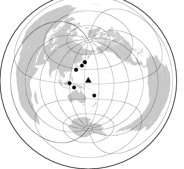
Azimuth Distribution of Events:
Prior Results for this Station
| Study | Thickness | Vp/Vs | Vp | Vs | Poissons Ratio | Extra |
| EARS | 11 km | 1.74 | 4.24 km/s | 2.433 km/s | 0.25 | |
| Crust2.0 | 12 km | 2.19 | 4.24 km/s | 1.94 km/s | 0.37 | A0,normal oceanic, 0.07 km seds. |
| Global Maxima | 11 km | 1.74 | 4.24 km/s | 2.433 km/s | 0.25 | amp=0.044045214 |
| Local Maxima 1 | 10 km | 2.01 | 4.24 km/s | 2.107 km/s | 0.34 | amp=0.02577151 |
| Local Maxima 2 | 30 km | 1.95 | 4.24 km/s | 2.174 km/s | 0.32 | amp=0.020627713 |
| Local Maxima 3 | 14 km | 1.68 | 4.24 km/s | 2.531 km/s | 0.22 | amp=0.015470157 |
| Local Maxima 4 | 38 km | 1.77 | 4.24 km/s | 2.389 km/s | 0.27 | amp=0.014116125 |
| Predicted Arrivals for vertical incidence (zero ray parameter) | |
| Ps | 1.88 SECOND |
| PpPs | 6.95 SECOND |
| PsPs/PpSs | 8.84 SECOND |
Events Processed for this Station
Download zip of receiver functions as SAC
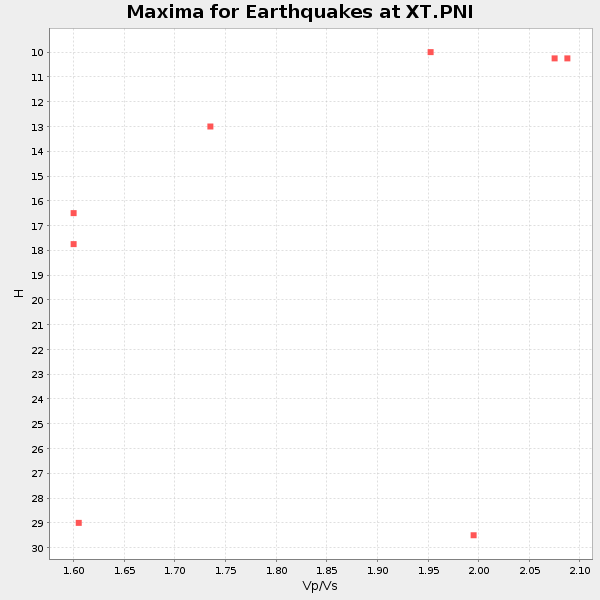
Plot maxima for each earthquake.
Events Used in the Stack
(8 events)| Radial Match | Distance | Baz | FERegion | Time | Lat/Lon | Depth | Magnitude |
| 96.095985 | 38.6 deg | 262.369 deg | Minahassa Peninsula, Sulawesi | 1996/01/01 08:05:11 GMT | (0.7, 120.0) | 33 km | 6.2 MB, 7.7 MS, 7.8 UNKNOWN, 7.8 MW |
| 95.67203 | 33.6 deg | 311.672 deg | Ryukyu Islands, Japan | 1995/10/18 10:37:26 GMT | (27.9, 130.3) | 27 km | 6.5 MB, 6.8 MS, 6.7 UNKNOWN, 7.1 MW |
| 95.301704 | 32.5 deg | 157.949 deg | Southeast Of Loyalty Islands | 1995/07/12 15:46:59 GMT | (-23.2, 170.8) | 33 km | 5.9 MB, 6.4 MS, 6.5 UNKNOWN, 6.4 MW |
| 94.480125 | 38.2 deg | 349.84 deg | Kuril Islands | 1995/12/03 18:01:08 GMT | (44.6, 149.4) | 33 km | 6.6 MB, 8.0 MS |
| 91.61118 | 32.1 deg | 244.981 deg | Banda Sea | 1995/12/25 04:43:24 GMT | (-6.9, 129.2) | 150 km | 6.2 MB, 7.1 UNKNOWN, 7.1 MW |
| 88.189026 | 33.4 deg | 336.968 deg | Off East Coast Of Honshu, Japan | 1996/02/16 15:22:57 GMT | (37.3, 142.5) | 33 km | 6.2 MB, 6.2 MS, 6.7 UNKNOWN, 6.6 MW |
| 82.72392 | 33.7 deg | 311.881 deg | Ryukyu Islands, Japan | 1995/10/19 02:41:37 GMT | (28.1, 130.3) | 31 km | 6.3 MB, 6.8 MS, 6.6 UNKNOWN, 6.6 MW |
| 80.64712 | 39.0 deg | 349.199 deg | Kuril Islands | 1996/02/22 14:59:09 GMT | (45.2, 148.6) | 133 km | 6.2 MB, 6.3 UNKNOWN, 6.3 MW |
Losers
(15 events)| Radial Match | Distance | Baz | FERegion | Time | Lat/Lon | Depth | Magnitude | Reason |
| 86.797874 | 38.3 deg | 351.415 deg | East Of Kuril Islands | 1995/12/03 18:14:27 GMT | (44.8, 150.7) | 33 km | 6.4 MB, 6.6 MS | |
| 72.60101 | 56.1 deg | 259.292 deg | Southern Sumatra, Indonesia | 1995/11/05 16:30:00 GMT | (-4.9, 103.2) | 58 km | 6.3 MB, 6.1 MS, 5.9 UNKNOWN, 6.3 MW | |
| 65.66967 | 36.0 deg | 142.97 deg | Fiji Islands Region | 1995/10/29 19:40:57 GMT | (-21.7, -179.5) | 611 km | 5.7 MB, 6.1 UNKNOWN | |
| 62.885807 | 33.8 deg | 311.896 deg | Ryukyu Islands, Japan | 1995/10/19 00:32:06 GMT | (28.1, 130.2) | 33 km | 5.9 MB, 6.3 MS, 6.1 UNKNOWN, 6.4 MW | |
| 62.30213 | 84.1 deg | 305.896 deg | Hindu Kush Region, Afghanistan | 1995/10/18 09:30:38 GMT | (36.4, 70.4) | 226 km | 5.4 MB, 6.2 UNKNOWN, 6.2 MW | |
| 62.28337 | 32.4 deg | 262.178 deg | Northern Molucca Sea | 1996/02/28 09:44:09 GMT | (1.7, 126.1) | 103 km | 6.1 MB, 6.4 UNKNOWN, 6.4 MW | |
| 54.883102 | 35.7 deg | 128.129 deg | Tonga Islands | 1995/11/13 07:38:45 GMT | (-15.1, -173.5) | 33 km | 5.7 MB, 5.9 MS, 6.1 UNKNOWN, 6.0 MW | |
| 46.610104 | 30.6 deg | 246.086 deg | Banda Sea | 1996/01/12 19:38:20 GMT | (-5.8, 130.2) | 33 km | 5.5 MS, 5.4 MB, 5.9 UNKNOWN, 5.8 MW | |
| 45.40402 | 69.7 deg | 176.703 deg | Balleny Islands Region | 1996/03/23 10:46:45 GMT | (-62.7, 164.9) | 10 km | 5.5 MS, 5.0 MB | |
| 43.273464 | 32.7 deg | 260.621 deg | Northern Molucca Sea | 1995/10/29 19:24:29 GMT | (0.8, 126.0) | 33 km | 6.1 MB, 5.4 MS | |
| 42.51257 | 33.7 deg | 312.022 deg | Ryukyu Islands, Japan | 1995/10/18 23:25:59 GMT | (28.2, 130.3) | 33 km | 5.8 MB, 5.9 MS, 6.0 UNKNOWN, 5.9 MW | |
| 41.577198 | 42.5 deg | 146.537 deg | Kermadec Islands Region | 1995/12/25 03:06:34 GMT | (-28.2, -176.9) | 33 km | 5.4 MB, 6.0 MS | |
| 40.578526 | 31.5 deg | 265.396 deg | Talaud Islands, Indonesia | 1995/11/13 02:17:51 GMT | (3.6, 126.7) | 33 km | 5.8 MB, 6.1 MS, 6.3 UNKNOWN, 6.1 MW | |
| 31.324518 | 47.1 deg | 154.542 deg | East Of North Island, N.Z. | 1996/03/22 17:31:06 GMT | (-35.2, -179.2) | 33 km | 5.6 MB, 5.7 MS, 6.0 UNKNOWN, 5.7 MS | |
| 21.770945 | 83.5 deg | 305.878 deg | Afghanistan-Tajikistan Bord Reg. | 1995/08/17 23:14:19 GMT | (36.5, 71.2) | 239 km | 5.7 UNKNOWN, 5.4 MB, 5.6 MW |
