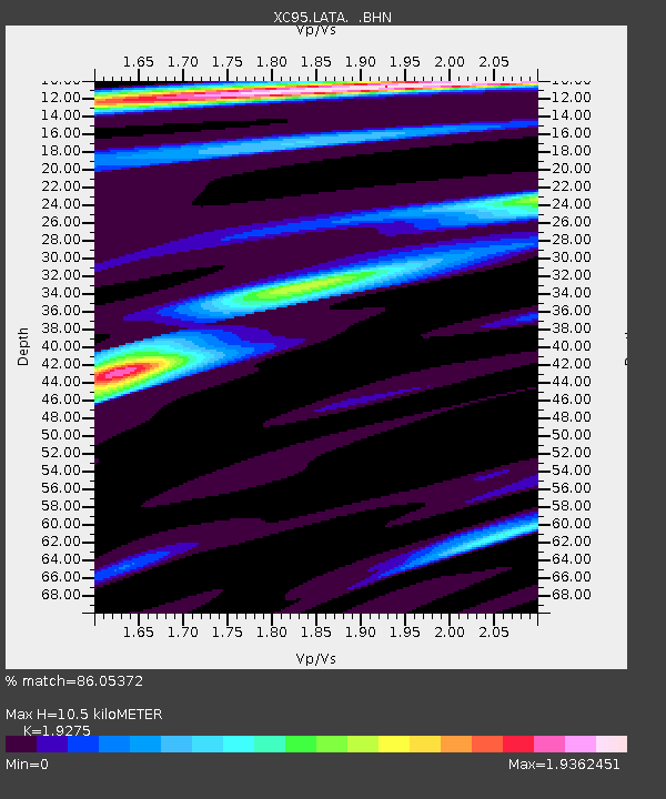
LATA Lake Taylor - Earthquake Result Viewer
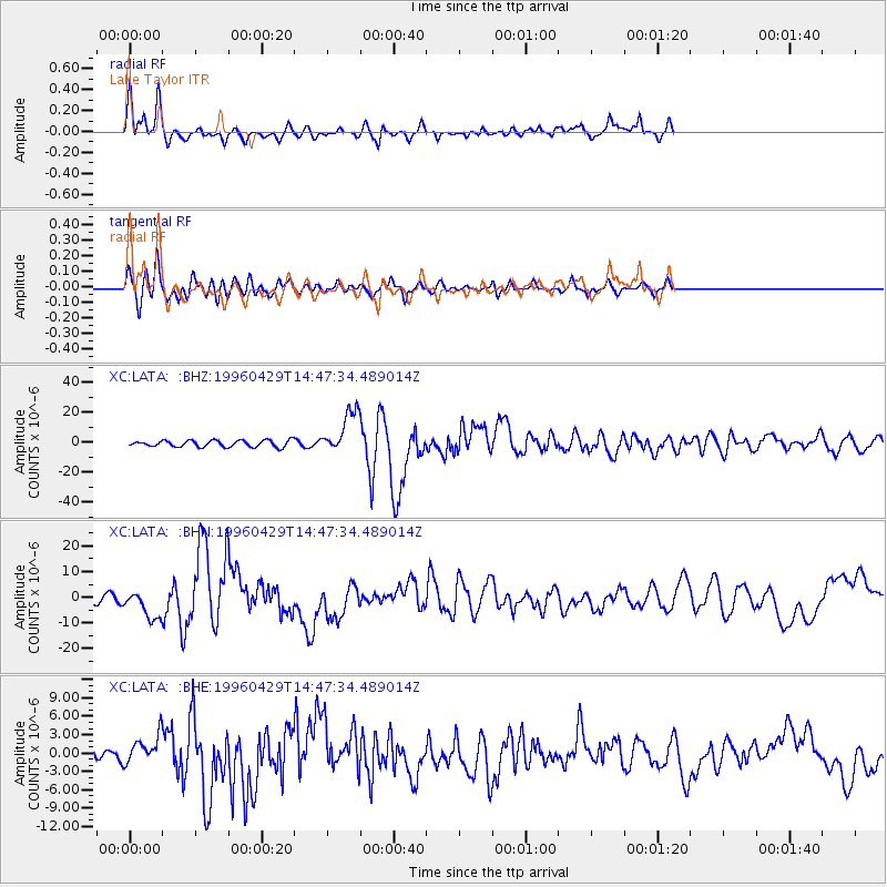
Earthquake location: Solomon Islands
Earthquake latitude/longitude: -6.5/155.0
Earthquake time(UTC): 1996/04/29 (120) 14:40:41 GMT
Earthquake Depth: 44 km
Earthquake Magnitude: 6.3 MB, 7.5 MS, 7.2 UNKNOWN, 6.8 ME
Earthquake Catalog/Contributor: WHDF/NEIC
Network: XC Southern Alps Passive Seismic Experiment
Station: LATA Lake Taylor
Lat/Lon: 42.78 S/172.27 E
Elevation: 640 m
Distance: 39.2 deg
Az: 159.772 deg
Baz: 332.183 deg
Ray Param: 0.07501221
Estimated Moho Depth: 10.5 km
Estimated Crust Vp/Vs: 1.93
Assumed Crust Vp: 6.461 km/s
Estimated Crust Vs: 3.352 km/s
Estimated Crust Poisson's Ratio: 0.32
Radial Match: 86.05372 %
Radial Bump: 400
Transverse Match: 82.465935 %
Transverse Bump: 400
SOD ConfigId: 6273
Insert Time: 2010-02-26 15:07:21.325 +0000
GWidth: 2.5
Max Bumps: 400
Tol: 0.001

Signal To Noise

ChannelStoNSTALTA
XC:LATA: :BHN:19960429T14:47:34.489014Z2.59852055.5079695E-62.119656E-6
XC:LATA: :BHE:19960429T14:47:34.489014Z2.73154662.2787804E-68.3424544E-7
XC:LATA: :BHZ:19960429T14:47:34.489014Z6.5773641.423944E-52.164916E-6
Arrivals
Ps1.6 SECOND
PpPs4.5 SECOND
PsPs/PpSs6.1 SECOND