
Station XC LATA - Lake Taylor
Network: XC95 - Southern Alps Passive Seismic Experiment
Nearby stations (2 deg radius)
| Station | Name | (Lat, Lon) | Start / End | Elevation |
| LATA | Lake Taylor | (-42.78, 172.27) | 1995-11-15 / 1996-12-31 | 640 m |
| Crust2 Type: | K2,forearc, New Zealand, 0.7 km seds. |
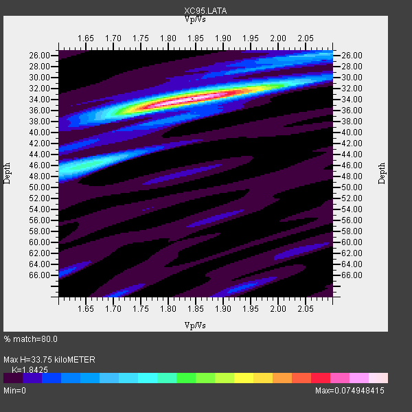
| Thickness Estimate: | 34 km |
| Thickness StdDev: | 1.0 km |
| Vp/Vs Estimate: | 1.84 |
| Vp/Vs StdDev: | 0.05 |
| Vs Estimate: | 3.507 km/s |
| Poisson's Ratio: | 0.29 |
| Peak Value: | 0.07 |
| Assumed Vp: | 6.461 km/s |
| Ps Weight: | 0.33333334 |
| PpPs Weight: | 0.33333334 |
| PsPs Weight: | 0.33333328 |
| Residual Complexity: | 0.379 |
| Nearby stations H: | +- |
| (2.0 deg) Vp/Vs: | +- |
1 with match > 90% ( 4.0 %) and 4 with match > 80% ( 16.0 %) out of 25.
Download stack as xyz text file.
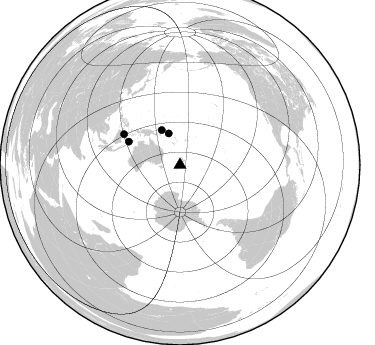
Azimuth Distribution of Events:
Prior Results for this Station
| Study | Thickness | Vp/Vs | Vp | Vs | Poissons Ratio | Extra |
| EARS | 34 km | 1.84 | 6.461 km/s | 3.507 km/s | 0.29 | |
| Crust2.0 | 35 km | 1.76 | 6.461 km/s | 3.663 km/s | 0.26 | K2,forearc, New Zealand, 0.7 km seds. |
| Global Maxima | 34 km | 1.84 | 6.461 km/s | 3.507 km/s | 0.29 | amp=0.074948415 |
| Local Maxima 1 | 46 km | 1.65 | 6.461 km/s | 3.904 km/s | 0.21 | amp=0.03180343 |
| Local Maxima 2 | 26 km | 2.08 | 6.461 km/s | 3.11 km/s | 0.35 | amp=0.022141246 |
| Local Maxima 3 | 36 km | 1.74 | 6.461 km/s | 3.719 km/s | 0.25 | amp=0.01712592 |
| Local Maxima 4 | 32 km | 1.96 | 6.461 km/s | 3.292 km/s | 0.32 | amp=0.0144575825 |
| Predicted Arrivals for vertical incidence (zero ray parameter) | |
| Ps | 4.40 SECOND |
| PpPs | 14.85 SECOND |
| PsPs/PpSs | 19.25 SECOND |
Events Processed for this Station
Download zip of receiver functions as SAC
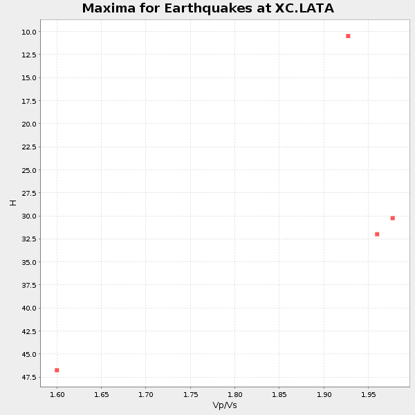
Plot maxima for each earthquake.
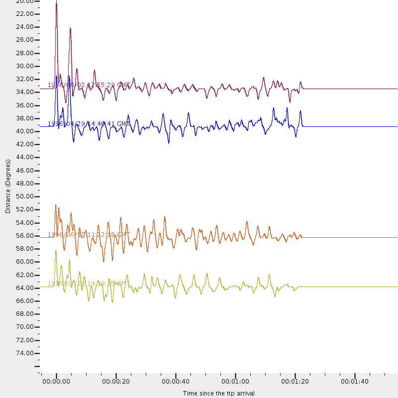
Events Used in the Stack
(4 events)| Radial Match | Distance | Baz | FERegion | Time | Lat/Lon | Depth | Magnitude |
| 93.97206 | 33.3 deg | 340.339 deg | Solomon Islands | 1996/08/02 12:55:29 GMT | (-10.8, 161.4) | 33 km | 6.2 MB, 7.1 MS, 6.9 UNKNOWN, 6.9 MW |
| 88.67423 | 56.2 deg | 294.429 deg | Flores Sea | 1996/06/17 11:22:18 GMT | (-7.1, 122.6) | 587 km | 6.6 MB, 7.9 UNKNOWN, 7.8 MW |
| 88.180954 | 63.7 deg | 298.741 deg | Minahassa Peninsula, Sulawesi | 1996/07/22 14:19:35 GMT | (1.0, 120.4) | 33 km | 6.0 MB, 6.9 MS, 7.0 UNKNOWN, 6.9 MW |
| 86.05372 | 39.2 deg | 332.183 deg | Solomon Islands | 1996/04/29 14:40:41 GMT | (-6.5, 155.0) | 44 km | 6.3 MB, 7.5 MS, 7.2 UNKNOWN, 6.8 ME |
Losers
(21 events)| Radial Match | Distance | Baz | FERegion | Time | Lat/Lon | Depth | Magnitude | Reason |
| 78.03347 | 66.8 deg | 309.505 deg | Mindanao, Philippines | 1996/09/20 04:11:04 GMT | (9.5, 126.3) | 33 km | 5.9 MB | |
| 77.45809 | 35.9 deg | 333.976 deg | Solomon Islands | 1996/06/03 08:15:39 GMT | (-9.3, 157.2) | 33 km | 5.6 MB, 6.0 MS, 6.1 UNKNOWN, 5.8 MS | |
| 76.60609 | 90.7 deg | 336.298 deg | Eastern Sea Of Japan | 1996/12/22 14:53:27 GMT | (43.2, 138.9) | 227 km | 6.0 MB, 6.5 UNKNOWN, 6.5 MW | |
| 76.41551 | 66.8 deg | 309.466 deg | Mindanao, Philippines | 1996/09/20 04:10:27 GMT | (9.5, 126.3) | 33 km | 5.8 MB, 6.4 MS, 6.6 UNKNOWN, 6.6 MW | |
| 76.11336 | 63.8 deg | 298.586 deg | Minahassa Peninsula, Sulawesi | 1996/07/16 10:07:36 GMT | (1.0, 120.3) | 33 km | 6.0 MB, 6.4 MS, 6.6 UNKNOWN, 6.6 MW | |
| 74.16383 | 36.3 deg | 336.793 deg | Solomon Islands | 1996/01/11 03:51:34 GMT | (-8.4, 158.6) | 96 km | 5.5 MB, 5.6 UNKNOWN, 5.9 MW | |
| 72.20434 | 70.0 deg | 310.427 deg | Samar, Philippines | 1996/06/11 18:22:55 GMT | (12.6, 125.2) | 33 km | 6.0 MB, 7.0 MS, 7.2 UNKNOWN, 7.1 MW | |
| 71.643906 | 30.2 deg | 28.98 deg | Tonga Islands | 1996/08/05 02:08:58 GMT | (-15.3, -173.1) | 41 km | 6.0 MB, 6.7 MS, 6.7 UNKNOWN, 6.2 ME | |
| 70.771965 | 64.8 deg | 331.588 deg | Mariana Islands | 1996/06/09 01:12:16 GMT | (17.4, 145.5) | 149 km | 6.0 MB, 5.9 MS, 6.5 UNKNOWN, 6.5 MW | |
| 70.599144 | 32.3 deg | 348.388 deg | Santa Cruz Islands | 1996/09/14 13:10:53 GMT | (-10.9, 166.0) | 73 km | 6.0 MB, 6.0 MS, 6.4 UNKNOWN, 6.4 MW | |
| 68.08603 | 79.5 deg | 312.984 deg | Taiwan Region | 1996/09/05 23:42:06 GMT | (21.9, 121.5) | 20 km | 6.4 MB, 6.6 MS, 6.8 UNKNOWN, 6.8 ME | |
| 63.656883 | 86.3 deg | 335.713 deg | Eastern Honshu, Japan | 1996/08/10 18:12:17 GMT | (38.9, 140.5) | 10 km | 6.0 MB, 5.7 MS, 5.9 UNKNOWN, 5.9 MW | |
| 61.50928 | 31.2 deg | 349.288 deg | Santa Cruz Islands | 1996/09/01 06:45:41 GMT | (-11.8, 166.6) | 187 km | 5.5 MB, 5.9 UNKNOWN, 5.8 MW | |
| 60.076294 | 59.5 deg | 289.592 deg | Bali Sea | 1996/11/02 00:08:50 GMT | (-7.6, 117.3) | 302 km | 5.5 MB, 5.8 UNKNOWN, 5.8 MW | |
| 57.042282 | 50.1 deg | 314.335 deg | Irian Jaya, Indonesia | 1996/12/26 20:48:23 GMT | (-2.2, 138.9) | 33 km | 6.0 MB, 6.1 MS, 6.3 UNKNOWN, 6.1 MW | |
| 57.026985 | 69.9 deg | 330.936 deg | Mariana Islands Region | 1996/07/06 21:36:28 GMT | (22.0, 142.8) | 241 km | 5.8 MB, 6.3 UNKNOWN, 6.2 MW | |
| 56.239506 | 61.4 deg | 300.046 deg | Minahassa Peninsula, Sulawesi | 1996/09/14 02:53:24 GMT | (-0.0, 122.8) | 181 km | 5.5 MB | |
| 50.0077 | 85.4 deg | 130.022 deg | Near Coast Of Central Chile | 1996/09/09 00:20:39 GMT | (-31.9, -71.6) | 39 km | 6.0 MB, 5.5 MS, 6.0 UNKNOWN, 5.8 ME | |
| 46.054497 | 64.6 deg | 236.188 deg | Mid-Indian Ridge | 1996/08/19 06:24:11 GMT | (-41.5, 80.4) | 10 km | 5.4 MB, 5.9 MS, 6.0 UNKNOWN, 5.9 MW | |
| 42.959156 | 66.9 deg | 309.717 deg | Mindanao, Philippines | 1996/09/25 09:26:45 GMT | (9.7, 126.4) | 33 km | 5.5 MB, 5.7 MS | |
| 38.021282 | 97.1 deg | 71.028 deg | Off Coast Of Jalisco, Mexico | 1995/12/11 14:09:24 GMT | (18.8, -105.5) | 33 km | 5.7 MB, 6.1 MS |
