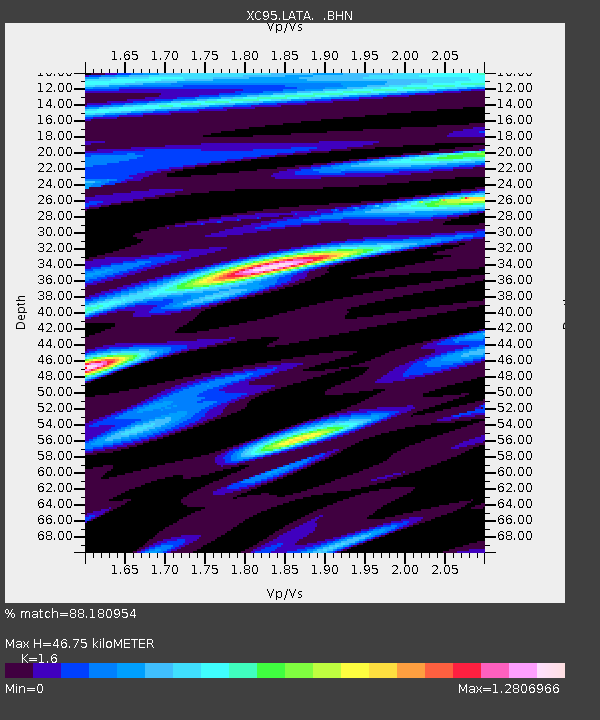
LATA Lake Taylor - Earthquake Result Viewer
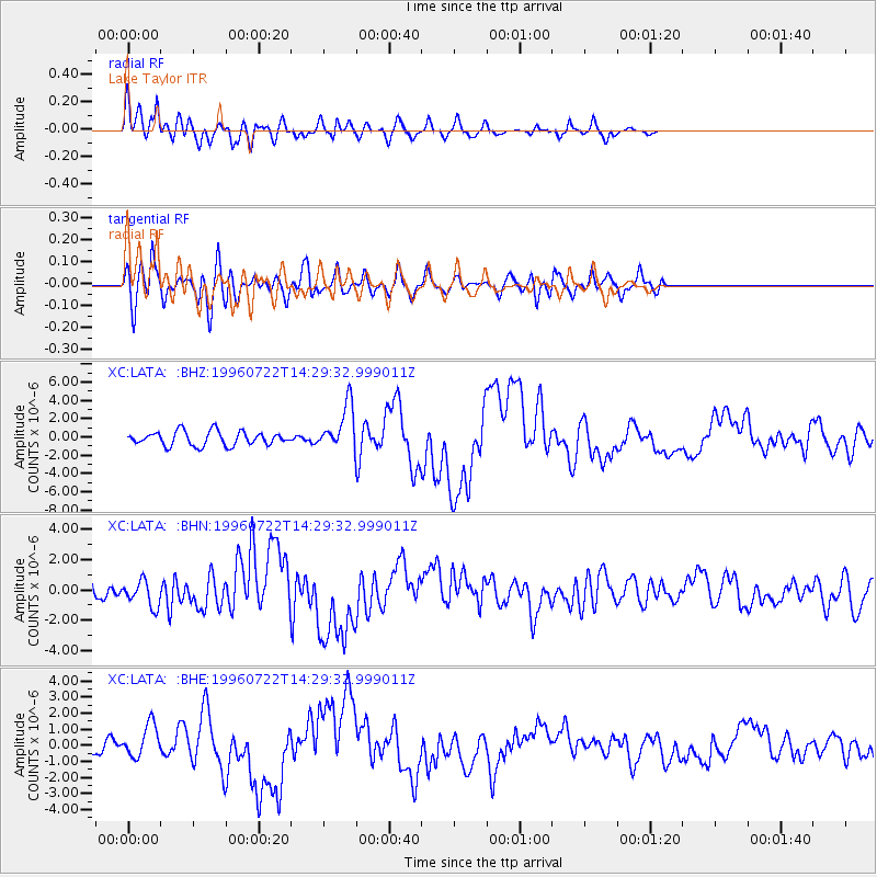
Earthquake location: Minahassa Peninsula, Sulawesi
Earthquake latitude/longitude: 1.0/120.4
Earthquake time(UTC): 1996/07/22 (204) 14:19:35 GMT
Earthquake Depth: 33 km
Earthquake Magnitude: 6.0 MB, 6.9 MS, 7.0 UNKNOWN, 6.9 MW
Earthquake Catalog/Contributor: WHDF/NEIC
Network: XC Southern Alps Passive Seismic Experiment
Station: LATA Lake Taylor
Lat/Lon: 42.78 S/172.27 E
Elevation: 640 m
Distance: 63.7 deg
Az: 139.788 deg
Baz: 298.741 deg
Ray Param: 0.059362087
Estimated Moho Depth: 46.75 km
Estimated Crust Vp/Vs: 1.60
Assumed Crust Vp: 6.461 km/s
Estimated Crust Vs: 4.038 km/s
Estimated Crust Poisson's Ratio: 0.18
Radial Match: 88.180954 %
Radial Bump: 400
Transverse Match: 67.31427 %
Transverse Bump: 400
SOD ConfigId: 6273
Insert Time: 2010-02-26 15:07:24.556 +0000
GWidth: 2.5
Max Bumps: 400
Tol: 0.001

Signal To Noise

ChannelStoNSTALTA
XC:LATA: :BHN:19960722T14:29:32.999011Z1.31135658.616846E-76.5709406E-7
XC:LATA: :BHE:19960722T14:29:32.999011Z1.82506841.033096E-65.660588E-7
XC:LATA: :BHZ:19960722T14:29:32.999011Z3.22804052.473112E-67.661341E-7
Arrivals
Ps4.6 SECOND
PpPs18 SECOND
PsPs/PpSs22 SECOND