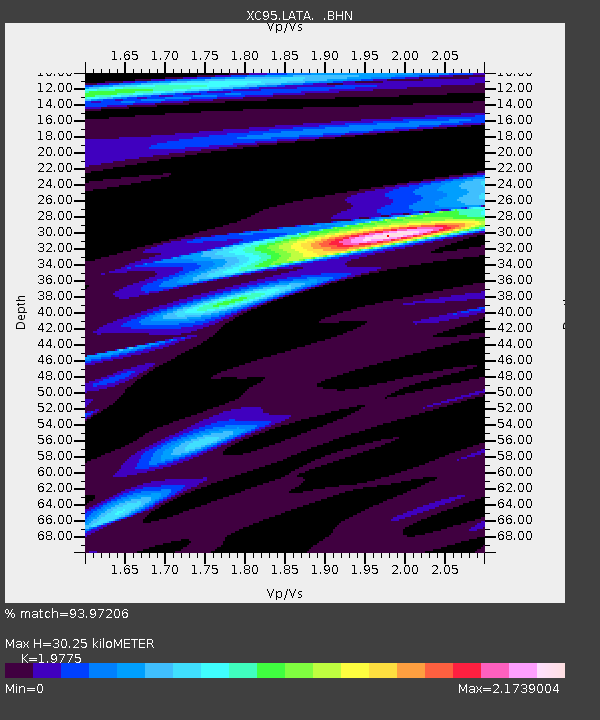
LATA Lake Taylor - Earthquake Result Viewer
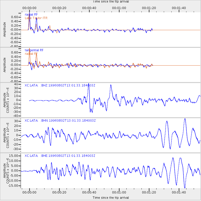
Earthquake location: Solomon Islands
Earthquake latitude/longitude: -10.8/161.4
Earthquake time(UTC): 1996/08/02 (215) 12:55:29 GMT
Earthquake Depth: 33 km
Earthquake Magnitude: 6.2 MB, 7.1 MS, 6.9 UNKNOWN, 6.9 MW
Earthquake Catalog/Contributor: WHDF/NEIC
Network: XC Southern Alps Passive Seismic Experiment
Station: LATA Lake Taylor
Lat/Lon: 42.78 S/172.27 E
Elevation: 640 m
Distance: 33.3 deg
Az: 165.399 deg
Baz: 340.339 deg
Ray Param: 0.07823601
Estimated Moho Depth: 30.25 km
Estimated Crust Vp/Vs: 1.98
Assumed Crust Vp: 6.461 km/s
Estimated Crust Vs: 3.267 km/s
Estimated Crust Poisson's Ratio: 0.33
Radial Match: 93.97206 %
Radial Bump: 287
Transverse Match: 75.176994 %
Transverse Bump: 400
SOD ConfigId: 6273
Insert Time: 2010-02-26 15:07:26.284 +0000
GWidth: 2.5
Max Bumps: 400
Tol: 0.001

Signal To Noise

ChannelStoNSTALTA
XC:LATA: :BHN:19960802T13:01:33.184003Z2.81502842.4017543E-68.531901E-7
XC:LATA: :BHE:19960802T13:01:33.184003Z0.898058834.5002682E-75.011106E-7
XC:LATA: :BHZ:19960802T13:01:33.184003Z3.7465593.2483633E-68.670258E-7
Arrivals
Ps4.9 SECOND
PpPs13 SECOND
PsPs/PpSs18 SECOND