You are here: Home > Network List > XC95 - Southern Alps Passive Seismic Experiment Stations List
> Station LATA Lake Taylor > Earthquake Result Viewer
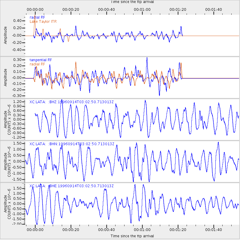
LATA Lake Taylor - Earthquake Result Viewer
*The percent match for this event was below the threshold and hence no stack was calculated.
| Earthquake location: |
Minahassa Peninsula, Sulawesi |
| Earthquake latitude/longitude: |
-0.0/122.8 |
| Earthquake time(UTC): |
1996/09/14 (258) 02:53:24 GMT |
| Earthquake Depth: |
181 km |
| Earthquake Magnitude: |
5.5 MB |
| Earthquake Catalog/Contributor: |
WHDF/NEIC |
|
| Network: |
XC Southern Alps Passive Seismic Experiment |
| Station: |
LATA Lake Taylor |
| Lat/Lon: |
42.78 S/172.27 E |
| Elevation: |
640 m |
|
| Distance: |
61.4 deg |
| Az: |
140.41 deg |
| Baz: |
300.046 deg |
| Ray Param: |
$rayparam |
*The percent match for this event was below the threshold and hence was not used in the summary stack. |
|
| Radial Match: |
56.239506 % |
| Radial Bump: |
385 |
| Transverse Match: |
55.214634 % |
| Transverse Bump: |
400 |
| SOD ConfigId: |
4480 |
| Insert Time: |
2010-02-26 15:07:43.999 +0000 |
| GWidth: |
2.5 |
| Max Bumps: |
400 |
| Tol: |
0.001 |
|
Signal To Noise
| Channel | StoN | STA | LTA |
| XC:LATA: :BHN:19960914T03:02:50.713013Z | 1.4772354 | 8.303577E-7 | 5.6210246E-7 |
| XC:LATA: :BHE:19960914T03:02:50.713013Z | 2.2049785 | 1.3288173E-6 | 6.026441E-7 |
| XC:LATA: :BHZ:19960914T03:02:50.713013Z | 0.54451185 | 3.5487716E-7 | 6.5173447E-7 |
| Arrivals |
| Ps | |
| PpPs | |
| PsPs/PpSs | |


