You are here: Home > Network List > XT97 - Colorado BB Array - Lodore Stations List
> Station HIAW XT.HIAW > Earthquake Result Viewer
HIAW XT.HIAW - Earthquake Result Viewer
| Earthquake location: |
Southern Alaska |
| Earthquake latitude/longitude: |
60.5/-153.2 |
| Earthquake time(UTC): |
1998/07/09 (190) 19:39:43 GMT |
| Earthquake Depth: |
145 km |
| Earthquake Magnitude: |
5.3 MB, 6.2 UNKNOWN, 6.2 MW |
| Earthquake Catalog/Contributor: |
WHDF/NEIC |
|
| Network: |
XT Colorado BB Array - Lodore |
| Station: |
HIAW XT.HIAW |
| Lat/Lon: |
41.01 N/108.73 W |
| Elevation: |
2105 m |
|
| Distance: |
33.4 deg |
| Az: |
105.394 deg |
| Baz: |
320.95 deg |
| Ray Param: |
0.07780269 |
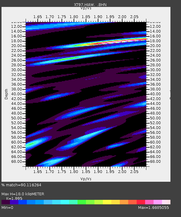
| Estimated Moho Depth: |
18.0 km |
| Estimated Crust Vp/Vs: |
2.00 |
| Assumed Crust Vp: |
6.207 km/s |
| Estimated Crust Vs: |
3.111 km/s |
| Estimated Crust Poisson's Ratio: |
0.33 |
|
| Radial Match: |
90.116264 % |
| Radial Bump: |
365 |
| Transverse Match: |
80.40923 % |
| Transverse Bump: |
400 |
| SOD ConfigId: |
4480 |
| Insert Time: |
2010-03-09 01:34:09.697 +0000 |
| GWidth: |
2.5 |
| Max Bumps: |
400 |
| Tol: |
0.001 |
|

Signal To Noise
| Channel | StoN | STA | LTA |
| XT:HIAW: :BHN:19980709T19:45:38.025Z | 2.5571096 | 2.7835154E-7 | 1.0885397E-7 |
| XT:HIAW: :BHE:19980709T19:45:38.025Z | 1.1041418 | 1.00682975E-7 | 9.118663E-8 |
| XT:HIAW: :BHZ:19980709T19:45:38.025Z | 1.4947796 | 9.782594E-8 | 6.544506E-8 |
| Arrivals |
| Ps | 3.1 SECOND |
| PpPs | 8.2 SECOND |
| PsPs/PpSs | 11 SECOND |


