
Station XT HIAW - XT.HIAW
Network: XT97 - Colorado BB Array - Lodore
Nearby stations (2 deg radius)
| Station | Name | (Lat, Lon) | Start / End | Elevation |
| HIAW | XT.HIAW | (41.01, -108.73) | 1997-08-01 / 1998-07-15 | 2105 m |
| Crust2 Type: | Q4,orogen/43km no ice, Tethian Belt, 5 km seds. |
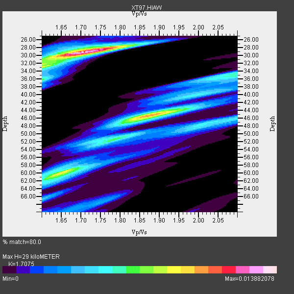
| Thickness Estimate: | 29 km |
| Thickness StdDev: | 9.3 km |
| Vp/Vs Estimate: | 1.71 |
| Vp/Vs StdDev: | 0.10 |
| Vs Estimate: | 3.635 km/s |
| Poisson's Ratio: | 0.24 |
| Peak Value: | 0.01 |
| Assumed Vp: | 6.207 km/s |
| Ps Weight: | 0.33333334 |
| PpPs Weight: | 0.33333334 |
| PsPs Weight: | 0.33333328 |
| Residual Complexity: | 0.785 |
| Nearby stations H: | +- |
| (2.0 deg) Vp/Vs: | +- |
8 with match > 90% ( 19.512196 %) and 17 with match > 80% ( 41.463413 %) out of 41.
Download stack as xyz text file.
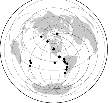
Azimuth Distribution of Events:
Prior Results for this Station
| Study | Thickness | Vp/Vs | Vp | Vs | Poissons Ratio | Extra |
| EARS | 29 km | 1.71 | 6.207 km/s | 3.635 km/s | 0.24 | |
| Crust2.0 | 43 km | 1.76 | 6.207 km/s | 3.535 km/s | 0.26 | Q4,orogen/43km no ice, Tethian Belt, 5 km seds. |
| Global Maxima | 29 km | 1.71 | 6.207 km/s | 3.635 km/s | 0.24 | amp=0.013882078 |
| Local Maxima 1 | 45 km | 1.87 | 6.207 km/s | 3.315 km/s | 0.30 | amp=0.010316784 |
| Local Maxima 2 | 60 km | 1.64 | 6.207 km/s | 3.773 km/s | 0.21 | amp=0.0086600715 |
| Local Maxima 3 | 33 km | 1.60 | 6.207 km/s | 3.879 km/s | 0.18 | amp=0.007293962 |
| Local Maxima 4 | 47 km | 2.02 | 6.207 km/s | 3.077 km/s | 0.34 | amp=0.005320635 |
| Predicted Arrivals for vertical incidence (zero ray parameter) | |
| Ps | 3.31 SECOND |
| PpPs | 12.65 SECOND |
| PsPs/PpSs | 15.96 SECOND |
Events Processed for this Station
Download zip of receiver functions as SAC
Plot maxima for each earthquake.
Events Used in the Stack
(17 events)| Radial Match | Distance | Baz | FERegion | Time | Lat/Lon | Depth | Magnitude |
| 97.43033 | 79.5 deg | 147.853 deg | Near Coast Of Central Chile | 1997/10/15 01:03:33 GMT | (-30.9, -71.2) | 58 km | 6.8 MB, 6.8 MS, 7.3 UNKNOWN, 7.1 MW |
| 96.54247 | 89.0 deg | 239.343 deg | South Of Fiji Islands | 1997/10/14 09:53:18 GMT | (-22.1, -176.8) | 167 km | 6.7 MB, 7.7 UNKNOWN, 7.4 ME |
| 94.68523 | 53.8 deg | 139.046 deg | Northern Peru | 1997/10/28 06:15:17 GMT | (-4.4, -76.7) | 112 km | 6.6 MB, 6.3 MS, 7.2 UNKNOWN, 6.6 ME |
| 93.30101 | 86.6 deg | 154.737 deg | Off Coast Of Southern Chile | 1998/04/01 22:42:56 GMT | (-40.3, -74.9) | 9.0 km | 6.2 MB, 6.0 MS, 6.7 UNKNOWN, 6.6 ME |
| 92.18404 | 73.8 deg | 143.595 deg | Near Coast Of Northern Chile | 1998/01/30 12:16:08 GMT | (-23.9, -70.2) | 42 km | 6.3 MB, 6.5 MS, 7.0 UNKNOWN, 6.7 ME |
| 91.25793 | 47.4 deg | 132.438 deg | Colombia | 1997/09/02 12:13:22 GMT | (3.8, -75.7) | 199 km | 6.5 MB, 6.8 UNKNOWN, 6.4 ME |
| 90.810844 | 79.5 deg | 148.024 deg | Near Coast Of Central Chile | 1998/01/12 10:14:07 GMT | (-31.0, -71.4) | 35 km | 5.8 MB, 6.2 MS, 6.6 UNKNOWN, 6.2 ME |
| 90.116264 | 33.4 deg | 320.95 deg | Southern Alaska | 1998/07/09 19:39:43 GMT | (60.5, -153.2) | 145 km | 5.3 MB, 6.2 UNKNOWN, 6.2 MW |
| 89.287834 | 45.3 deg | 175.735 deg | Central East Pacific Rise | 1997/08/15 07:37:49 GMT | (-4.4, -105.7) | 10 km | 5.3 MB, 5.8 MS, 6.2 UNKNOWN, 6.1 MW |
| 89.06174 | 59.3 deg | 315.21 deg | Off East Coast Of Kamchatka | 1998/06/01 05:34:03 GMT | (52.9, 160.1) | 44 km | 6.2 MB, 6.3 MS, 6.5 UNKNOWN, 6.4 MW |
| 88.99139 | 87.3 deg | 244.091 deg | Fiji Islands Region | 1998/03/29 19:48:16 GMT | (-17.6, -179.1) | 537 km | 6.5 MB, 7.2 UNKNOWN, 7.1 MW |
| 87.36081 | 65.8 deg | 136.852 deg | Peru-Bolivia Border Region | 1997/11/28 22:53:41 GMT | (-13.7, -68.8) | 586 km | 6.4 MB, 6.6 UNKNOWN, 6.6 MW |
| 86.39571 | 30.5 deg | 145.495 deg | Guatemala | 1998/01/10 08:20:05 GMT | (14.4, -91.5) | 33 km | 6.1 MB, 6.2 MS, 6.6 UNKNOWN, 6.6 ME |
| 85.530556 | 96.3 deg | 234.826 deg | Kermadec Islands, New Zealand | 1998/07/09 14:45:39 GMT | (-30.5, -179.0) | 130 km | 6.2 MB, 6.2 MS, 6.9 UNKNOWN, 6.4 ME |
| 84.1701 | 32.2 deg | 141.452 deg | El Salvador | 1997/12/18 15:02:00 GMT | (13.8, -88.7) | 182 km | 5.3 MB, 6.1 UNKNOWN, 6.0 MW |
| 83.98031 | 58.3 deg | 138.776 deg | Peru-Brazil Border Region | 1998/04/03 22:01:48 GMT | (-8.1, -74.2) | 165 km | 6.1 MB, 5.6 MS, 6.6 UNKNOWN, 6.6 MW |
| 81.19082 | 53.4 deg | 11.894 deg | Greenland Sea | 1998/03/21 16:33:11 GMT | (79.9, 1.9) | 10 km | 5.9 MB, 6.1 MS, 6.2 UNKNOWN, 6.2 MW |
Losers
(24 events)| Radial Match | Distance | Baz | FERegion | Time | Lat/Lon | Depth | Magnitude | Reason |
| 79.18058 | 49.3 deg | 307.701 deg | Rat Islands, Aleutian Islands | 1997/12/17 04:38:51 GMT | (51.2, 178.9) | 20 km | 5.8 MB, 6.5 MS, 6.7 UNKNOWN, 6.1 ME | |
| 77.85648 | 47.3 deg | 132.42 deg | Colombia | 1997/12/11 07:56:28 GMT | (3.9, -75.8) | 178 km | 6.0 MB, 6.4 UNKNOWN, 6.3 MW | |
| 76.77787 | 81.5 deg | 145.567 deg | San Juan Province, Argentina | 1998/06/07 16:10:46 GMT | (-31.5, -67.8) | 113 km | 5.6 MB, 5.9 UNKNOWN, 5.9 MW | |
| 76.364235 | 58.0 deg | 315.788 deg | Off East Coast Of Kamchatka | 1997/12/05 11:35:19 GMT | (53.9, 161.6) | 33 km | 5.7 MB | |
| 75.840645 | 94.2 deg | 235.27 deg | Kermadec Islands Region | 1997/09/20 16:11:32 GMT | (-28.7, -177.6) | 30 km | 6.1 MB, 7.0 MS, 7.2 UNKNOWN, 6.7 ME | |
| 74.95809 | 30.5 deg | 145.478 deg | Guatemala | 1998/03/03 02:24:43 GMT | (14.4, -91.5) | 63 km | 5.5 MB, 5.4 MS, 6.2 UNKNOWN, 6.1 MW | |
| 72.1876 | 80.9 deg | 309.291 deg | Near East Coast Of Honshu, Japan | 1998/06/14 13:17:08 GMT | (35.4, 140.5) | 45 km | 5.5 MB, 5.3 MS, 5.8 UNKNOWN, 5.8 MW | |
| 70.500725 | 86.2 deg | 245.546 deg | Fiji Islands Region | 1998/01/14 17:24:10 GMT | (-15.7, -179.3) | 33 km | 5.8 MB, 6.5 MS, 6.5 UNKNOWN, 6.5 MW | |
| 70.37088 | 96.1 deg | 234.302 deg | Kermadec Islands, New Zealand | 1997/10/27 09:32:59 GMT | (-30.8, -178.5) | 33 km | 5.5 MB, 5.4 MS | |
| 68.24795 | 60.6 deg | 140.594 deg | Central Peru | 1998/02/19 04:21:30 GMT | (-11.0, -74.4) | 33 km | 5.8 MB, 5.4 MS, 6.0 UNKNOWN, 5.9 MW | |
| 66.86327 | 31.4 deg | 144.869 deg | Near Coast Of Guatemala | 1998/05/10 06:05:58 GMT | (13.7, -90.7) | 33 km | 5.3 MB, 5.9 MS, 6.3 UNKNOWN, 5.3 MD | |
| 66.67862 | 31.6 deg | 144.098 deg | Near Coast Of Guatemala | 1997/12/22 10:03:45 GMT | (13.7, -90.3) | 59 km | 5.1 MB, 6.1 UNKNOWN, 5.2 MD | |
| 64.08583 | 95.3 deg | 239.291 deg | South Of Fiji Islands | 1997/09/04 04:23:37 GMT | (-26.6, 178.3) | 625 km | 6.3 MB, 6.8 UNKNOWN, 6.5 ME | |
| 63.853687 | 89.1 deg | 37.891 deg | Ionian Sea | 1997/11/18 13:07:41 GMT | (37.6, 20.7) | 33 km | 5.9 MB, 6.4 MS, 6.7 UNKNOWN, 6.1 ML | |
| 63.59089 | 30.4 deg | 147.078 deg | Near Coast Of Chiapas, Mexico | 1997/12/25 22:16:19 GMT | (14.1, -92.3) | 10 km | 5.4 MB, 5.3 MS, 5.8 UNKNOWN, 5.5 MD | |
| 61.619957 | 79.7 deg | 310.244 deg | Near East Coast Of Honshu, Japan | 1998/04/09 08:45:40 GMT | (36.9, 140.8) | 111 km | 5.6 UNKNOWN, 5.3 MB, 5.5 MW | |
| 61.17957 | 90.9 deg | 241.052 deg | South Of Fiji Islands | 1998/05/16 02:22:03 GMT | (-22.2, -179.5) | 586 km | 6.1 MB, 6.8 UNKNOWN | |
| 57.83147 | 83.7 deg | 309.338 deg | Southeast Of Honshu, Japan | 1998/02/28 17:38:48 GMT | (33.5, 138.1) | 291 km | 5.7 UNKNOWN, 5.3 MB, 5.7 MW | |
| 57.394566 | 97.1 deg | 311.902 deg | Southwestern Ryukyu Isl., Japan | 1997/08/13 04:45:04 GMT | (25.0, 125.8) | 55 km | 6.0 MB, 5.6 MS, 6.1 UNKNOWN, 6.1 MW | |
| 55.71477 | 92.7 deg | 291.314 deg | Mariana Islands | 1998/05/15 05:58:06 GMT | (14.2, 144.9) | 154 km | 5.7 MB, 6.0 UNKNOWN, 6.0 MW | |
| 54.387424 | 88.7 deg | 240.919 deg | Fiji Islands Region | 1997/08/25 11:59:00 GMT | (-20.8, -177.8) | 394 km | 5.5 UNKNOWN, 5.3 MB | |
| 52.789833 | 89.5 deg | 241.558 deg | Fiji Islands Region | 1997/10/17 15:02:00 GMT | (-20.9, -178.8) | 579 km | 5.3 MB, 6.0 UNKNOWN, 6.0 MW | |
| 48.654793 | 73.4 deg | 141.353 deg | Northern Chile | 1997/09/28 23:13:13 GMT | (-22.4, -68.4) | 107 km | 5.7 MB, 5.6 UNKNOWN, 5.6 MW | |
| 47.571014 | 85.1 deg | 40.332 deg | Southern Italy | 1998/05/18 17:19:04 GMT | (39.3, 15.1) | 280 km | 5.6 MB |
