You are here: Home > Network List > XC95 - Southern Alps Passive Seismic Experiment Stations List
> Station LU2A Lauder, New Zealand 2nd site > Earthquake Result Viewer
LU2A Lauder, New Zealand 2nd site - Earthquake Result Viewer

| Earthquake location: |
Flores Sea |
| Earthquake latitude/longitude: |
-7.1/122.6 |
| Earthquake time(UTC): |
1996/06/17 (169) 11:22:18 GMT |
| Earthquake Depth: |
587 km |
| Earthquake Magnitude: |
6.6 MB, 7.9 UNKNOWN, 7.8 MW |
| Earthquake Catalog/Contributor: |
WHDF/NEIC |
|
| Network: |
XC Southern Alps Passive Seismic Experiment |
| Station: |
LU2A Lauder, New Zealand 2nd site |
| Lat/Lon: |
45.04 S/169.70 E |
| Elevation: |
359 m |
|
| Distance: |
55.5 deg |
| Az: |
140.942 deg |
| Baz: |
298.128 deg |
| Ray Param: |
0.062221155 |
| Estimated Moho Depth: |
27.5 km |
| Estimated Crust Vp/Vs: |
1.89 |
| Assumed Crust Vp: |
6.461 km/s |
| Estimated Crust Vs: |
3.423 km/s |
| Estimated Crust Poisson's Ratio: |
0.30 |
|
| Radial Match: |
90.63873 % |
| Radial Bump: |
400 |
| Transverse Match: |
67.00958 % |
| Transverse Bump: |
400 |
| SOD ConfigId: |
6273 |
| Insert Time: |
2010-02-26 15:07:54.905 +0000 |
| GWidth: |
2.5 |
| Max Bumps: |
400 |
| Tol: |
0.001 |
|
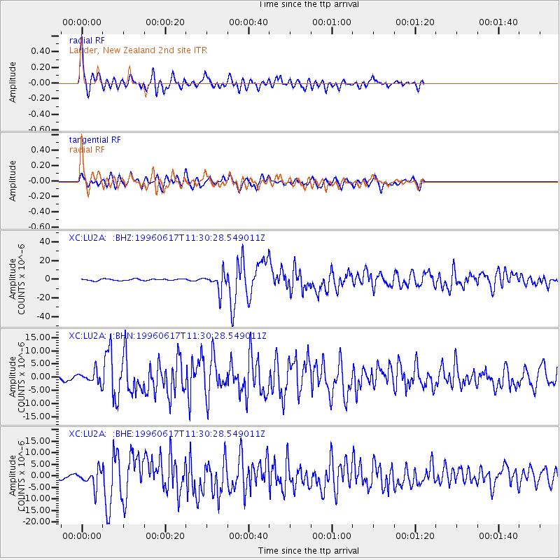
Signal To Noise
| Channel | StoN | STA | LTA |
| XC:LU2A: :BHN:19960617T11:30:28.549011Z | 3.0146446 | 2.2658273E-6 | 7.516068E-7 |
| XC:LU2A: :BHE:19960617T11:30:28.549011Z | 3.4553053 | 3.7687241E-6 | 1.0907065E-6 |
| XC:LU2A: :BHZ:19960617T11:30:28.549011Z | 11.713207 | 1.000177E-5 | 8.5388825E-7 |
| Arrivals |
| Ps | 4.0 SECOND |
| PpPs | 12 SECOND |
| PsPs/PpSs | 16 SECOND |


