
Station XC LU2A - Lauder, New Zealand 2nd site
Network: XC95 - Southern Alps Passive Seismic Experiment
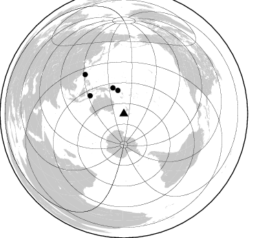
Nearby stations (2 deg radius)
| Station | Name | (Lat, Lon) | Start / End | Elevation |
| LU2A | Lauder, New Zealand 2nd site | (-45.04, 169.70) | 1996-01-27 / 1996-12-31 | 359 m |
| Crust2 Type: | K2,forearc, New Zealand, 0.7 km seds. |
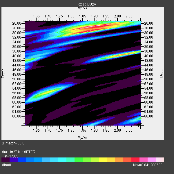
| Thickness Estimate: | 27 km |
| Thickness StdDev: | 9.8 km |
| Vp/Vs Estimate: | 1.90 |
| Vp/Vs StdDev: | 0.10 |
| Vs Estimate: | 3.392 km/s |
| Poisson's Ratio: | 0.31 |
| Peak Value: | 0.04 |
| Assumed Vp: | 6.461 km/s |
| Ps Weight: | 0.33333334 |
| PpPs Weight: | 0.33333334 |
| PsPs Weight: | 0.33333328 |
| Residual Complexity: | 0.655 |
| Nearby stations H: | +- |
| (2.0 deg) Vp/Vs: | +- |
1 with match > 90% ( 3.7037036 %) and 4 with match > 80% ( 14.814815 %) out of 27.
Download stack as xyz text file.
Azimuth Distribution of Events:
Prior Results for this Station
| Study | Thickness | Vp/Vs | Vp | Vs | Poissons Ratio | Extra |
| EARS | 27 km | 1.90 | 6.461 km/s | 3.392 km/s | 0.31 | |
| Crust2.0 | 35 km | 1.76 | 6.461 km/s | 3.663 km/s | 0.26 | K2,forearc, New Zealand, 0.7 km seds. |
| Global Maxima | 27 km | 1.90 | 6.461 km/s | 3.392 km/s | 0.31 | amp=0.041208733 |
| Local Maxima 1 | 39 km | 2.03 | 6.461 km/s | 3.191 km/s | 0.34 | amp=0.030866755 |
| Local Maxima 2 | 29 km | 1.88 | 6.461 km/s | 3.428 km/s | 0.30 | amp=0.026021425 |
| Local Maxima 3 | 56 km | 1.69 | 6.461 km/s | 3.818 km/s | 0.23 | amp=0.025791118 |
| Local Maxima 4 | 41 km | 1.62 | 6.461 km/s | 4.001 km/s | 0.19 | amp=0.020966906 |
| Predicted Arrivals for vertical incidence (zero ray parameter) | |
| Ps | 3.78 SECOND |
| PpPs | 12.14 SECOND |
| PsPs/PpSs | 15.92 SECOND |
Events Processed for this Station
Download zip of receiver functions as SAC
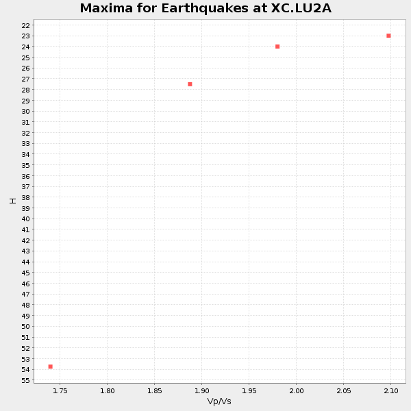
Plot maxima for each earthquake.
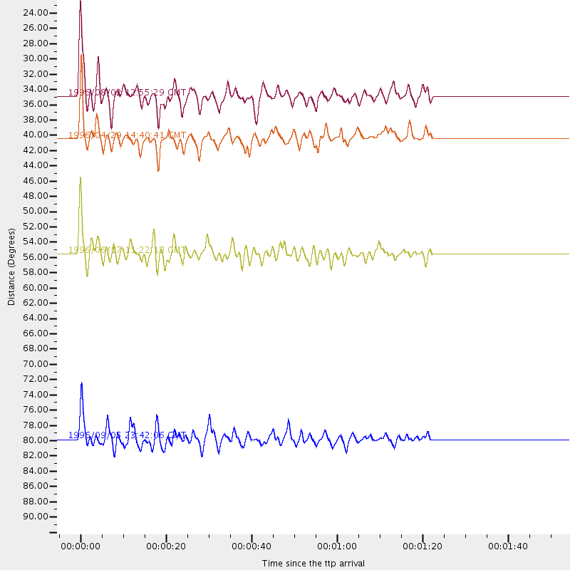
Events Used in the Stack
(4 events)| Radial Match | Distance | Baz | FERegion | Time | Lat/Lon | Depth | Magnitude |
| 90.63873 | 55.5 deg | 298.128 deg | Flores Sea | 1996/06/17 11:22:18 GMT | (-7.1, 122.6) | 587 km | 6.6 MB, 7.9 UNKNOWN, 7.8 MW |
| 88.949394 | 34.9 deg | 345.707 deg | Solomon Islands | 1996/08/02 12:55:29 GMT | (-10.8, 161.4) | 33 km | 6.2 MB, 7.1 MS, 6.9 UNKNOWN, 6.9 MW |
| 82.289116 | 79.8 deg | 315.287 deg | Taiwan Region | 1996/09/05 23:42:06 GMT | (21.9, 121.5) | 20 km | 6.4 MB, 6.6 MS, 6.8 UNKNOWN, 6.8 ME |
| 82.20493 | 40.5 deg | 337.122 deg | Solomon Islands | 1996/04/29 14:40:41 GMT | (-6.5, 155.0) | 44 km | 6.3 MB, 7.5 MS, 7.2 UNKNOWN, 6.8 ME |
Losers
(23 events)| Radial Match | Distance | Baz | FERegion | Time | Lat/Lon | Depth | Magnitude | Reason |
| 84.33444 | 67.0 deg | 312.731 deg | Mindanao, Philippines | 1996/09/25 09:26:45 GMT | (9.7, 126.4) | 33 km | 5.5 MB, 5.7 MS | |
| 77.758354 | 39.7 deg | 337.706 deg | Solomon Islands | 1996/10/14 23:26:20 GMT | (-7.1, 155.6) | 24 km | 5.9 MB, 6.9 MS, 6.8 UNKNOWN, 6.3 ME | |
| 77.36271 | 63.2 deg | 301.954 deg | Minahassa Peninsula, Sulawesi | 1996/07/22 14:19:35 GMT | (1.0, 120.4) | 33 km | 6.0 MB, 6.9 MS, 7.0 UNKNOWN, 6.9 MW | |
| 75.03069 | 84.1 deg | 328.04 deg | Kyushu, Japan | 1996/10/19 14:44:40 GMT | (31.9, 131.5) | 22 km | 6.3 MB, 6.6 MS, 7.0 UNKNOWN, 6.6 ME | |
| 71.256256 | 66.0 deg | 334.585 deg | Mariana Islands | 1996/06/09 01:12:16 GMT | (17.4, 145.5) | 149 km | 6.0 MB, 5.9 MS, 6.5 UNKNOWN, 6.5 MW | |
| 71.045654 | 49.2 deg | 124.408 deg | Southern East Pacific Rise | 1996/06/04 04:13:16 GMT | (-50.0, -114.8) | 10 km | 5.7 MS, 5.3 MB, 6.0 UNKNOWN, 5.9 MW | |
| 67.6961 | 67.1 deg | 335.192 deg | Mariana Islands | 1996/07/15 16:51:22 GMT | (18.7, 145.6) | 177 km | 5.9 MB, 6.3 UNKNOWN, 6.3 MW | |
| 67.09459 | 77.7 deg | 171.045 deg | South Sandwich Islands Region | 1996/05/30 03:04:37 GMT | (-56.7, -26.3) | 84 km | 5.7 MB, 6.1 UNKNOWN, 5.3 MW | |
| 66.58937 | 61.8 deg | 238.413 deg | Mid-Indian Ridge | 1996/08/19 06:24:11 GMT | (-41.5, 80.4) | 10 km | 5.4 MB, 5.9 MS, 6.0 UNKNOWN, 5.9 MW | |
| 66.43484 | 84.3 deg | 336.774 deg | Near East Coast Of Honshu, Japan | 1996/09/11 02:37:14 GMT | (35.5, 140.9) | 55 km | 6.1 MB, 5.7 MS, 6.2 UNKNOWN, 6.1 MW | |
| 61.05482 | 92.0 deg | 338.009 deg | Eastern Sea Of Japan | 1996/12/22 14:53:27 GMT | (43.2, 138.9) | 227 km | 6.0 MB, 6.5 UNKNOWN, 6.5 MW | |
| 60.53687 | 42.6 deg | 332.444 deg | New Britain Region, P.N.G. | 1996/12/26 19:34:11 GMT | (-5.4, 151.4) | 107 km | 5.5 MS, 5.3 MB, 5.8 UNKNOWN, 5.8 MW | |
| 59.69917 | 96.6 deg | 7.582 deg | Andreanof Islands, Aleutian Is. | 1996/06/12 02:16:48 GMT | (51.4, -178.2) | 33 km | 5.5 MB, 5.3 MS, 5.7 UNKNOWN, 5.6 ML | |
| 59.169437 | 50.0 deg | 241.296 deg | Southeast Indian Ridge | 1996/10/08 01:36:53 GMT | (-45.8, 96.0) | 10 km | 5.2 MB, 5.9 MS, 6.1 UNKNOWN, 6.0 MW | |
| 59.145744 | 47.1 deg | 331.896 deg | New Ireland Region, P.N.G. | 1996/11/01 03:32:34 GMT | (-1.3, 149.5) | 33 km | 5.7 MB, 5.7 MS, 5.9 UNKNOWN, 5.8 MW | |
| 57.826157 | 66.8 deg | 312.528 deg | Mindanao, Philippines | 1996/09/20 04:11:04 GMT | (9.5, 126.3) | 33 km | 5.9 MB | |
| 57.2764 | 33.0 deg | 31.511 deg | Tonga Islands | 1996/08/05 02:08:58 GMT | (-15.3, -173.1) | 41 km | 6.0 MB, 6.7 MS, 6.7 UNKNOWN, 6.2 ME | |
| 56.7939 | 71.0 deg | 333.662 deg | Mariana Islands Region | 1996/07/06 21:36:28 GMT | (22.0, 142.8) | 241 km | 5.8 MB, 6.3 UNKNOWN, 6.2 MW | |
| 56.624302 | 42.4 deg | 337.692 deg | Solomon Islands | 1996/05/02 13:34:28 GMT | (-4.5, 154.8) | 500 km | 5.6 MB, 6.6 UNKNOWN, 6.5 MW | |
| 54.75749 | 70.1 deg | 313.258 deg | Samar, Philippines | 1996/06/11 18:22:55 GMT | (12.6, 125.2) | 33 km | 6.0 MB, 7.0 MS, 7.2 UNKNOWN, 7.1 MW | |
| 47.20775 | 40.4 deg | 336.84 deg | Solomon Islands | 1996/05/01 09:21:24 GMT | (-6.7, 154.8) | 33 km | 5.5 MB, 5.9 MS, 6.0 UNKNOWN, 5.9 MW | |
| 45.808483 | 69.2 deg | 313.072 deg | Samar, Philippines | 1996/10/02 09:48:01 GMT | (11.8, 125.5) | 33 km | 6.0 MB, 6.4 MS, 6.4 UNKNOWN, 6.3 MW | |
| 34.87356 | 74.5 deg | 282.945 deg | Southern Sumatra, Indonesia | 1996/08/09 00:27:05 GMT | (-2.0, 99.7) | 33 km | 5.5 MS, 5.4 MB, 5.8 UNKNOWN, 5.7 MW |
