You are here: Home > Network List > XT97 - Colorado BB Array - Lodore Stations List
> Station LOOK XT.LOOK > Earthquake Result Viewer
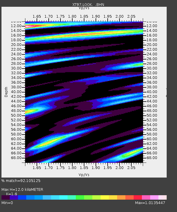
LOOK XT.LOOK - Earthquake Result Viewer
| Earthquake location: |
South Of Fiji Islands |
| Earthquake latitude/longitude: |
-22.1/-176.8 |
| Earthquake time(UTC): |
1997/10/14 (287) 09:53:18 GMT |
| Earthquake Depth: |
167 km |
| Earthquake Magnitude: |
6.7 MB, 7.7 UNKNOWN, 7.4 ME |
| Earthquake Catalog/Contributor: |
WHDF/NEIC |
|
| Network: |
XT Colorado BB Array - Lodore |
| Station: |
LOOK XT.LOOK |
| Lat/Lon: |
40.86 N/108.48 W |
| Elevation: |
2415 m |
|
| Distance: |
89.1 deg |
| Az: |
44.808 deg |
| Baz: |
239.511 deg |
| Ray Param: |
0.041759927 |
| Estimated Moho Depth: |
12.0 km |
| Estimated Crust Vp/Vs: |
1.60 |
| Assumed Crust Vp: |
6.207 km/s |
| Estimated Crust Vs: |
3.879 km/s |
| Estimated Crust Poisson's Ratio: |
0.18 |
|
| Radial Match: |
92.105125 % |
| Radial Bump: |
400 |
| Transverse Match: |
86.56342 % |
| Transverse Bump: |
400 |
| SOD ConfigId: |
6273 |
| Insert Time: |
2010-03-09 01:38:51.484 +0000 |
| GWidth: |
2.5 |
| Max Bumps: |
400 |
| Tol: |
0.001 |
|

Signal To Noise
| Channel | StoN | STA | LTA |
| XT:LOOK: :BHN:19971014T10:05:23.000024Z | 0.5628839 | 2.3896447E-7 | 4.2453598E-7 |
| XT:LOOK: :BHE:19971014T10:05:23.000024Z | 1.0766782 | 4.3909594E-7 | 4.078247E-7 |
| XT:LOOK: :BHZ:19971014T10:05:23.000024Z | 7.981913 | 1.6300252E-6 | 2.0421486E-7 |
| Arrivals |
| Ps | 1.2 SECOND |
| PpPs | 4.9 SECOND |
| PsPs/PpSs | 6.1 SECOND |


