
Station XT LOOK - XT.LOOK
Network: XT97 - Colorado BB Array - Lodore
Nearby stations (2 deg radius)
| Station | Name | (Lat, Lon) | Start / End | Elevation |
| LOOK | XT.LOOK | (40.86, -108.48) | 1997-08-01 / 1998-07-15 | 2415 m |
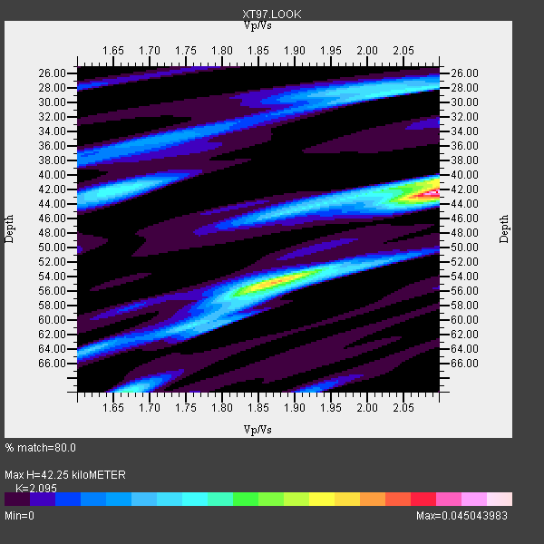
| Crust2 Type: | Q4,orogen/43km no ice, Tethian Belt, 5 km seds. |
| Thickness Estimate: | 42 km |
| Thickness StdDev: | 8.8 km |
| Vp/Vs Estimate: | 2.10 |
| Vp/Vs StdDev: | 0.19 |
| Vs Estimate: | 2.963 km/s |
| Poisson's Ratio: | 0.35 |
| Peak Value: | 0.05 |
| Assumed Vp: | 6.207 km/s |
| Ps Weight: | 0.33333334 |
| PpPs Weight: | 0.33333334 |
| PsPs Weight: | 0.33333328 |
| Residual Complexity: | 0.785 |
| Nearby stations H: | +- |
| (2.0 deg) Vp/Vs: | +- |
1 with match > 90% ( 3.5714285 %) and 4 with match > 80% ( 14.285714 %) out of 28.
Download stack as xyz text file.
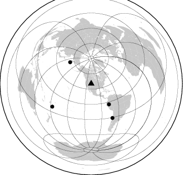
Azimuth Distribution of Events:
Prior Results for this Station
| Study | Thickness | Vp/Vs | Vp | Vs | Poissons Ratio | Extra |
| EARS | 42 km | 2.10 | 6.207 km/s | 2.963 km/s | 0.35 | |
| Crust2.0 | 43 km | 1.76 | 6.207 km/s | 3.535 km/s | 0.26 | Q4,orogen/43km no ice, Tethian Belt, 5 km seds. |
| Global Maxima | 42 km | 2.10 | 6.207 km/s | 2.963 km/s | 0.35 | amp=0.045043983 |
| Local Maxima 1 | 54 km | 1.89 | 6.207 km/s | 3.284 km/s | 0.31 | amp=0.0246297 |
| Local Maxima 2 | 41 km | 2.08 | 6.207 km/s | 2.984 km/s | 0.35 | amp=0.02001409 |
| Local Maxima 3 | 28 km | 2.05 | 6.207 km/s | 3.024 km/s | 0.34 | amp=0.01803344 |
| Local Maxima 4 | 42 km | 1.65 | 6.207 km/s | 3.75 km/s | 0.21 | amp=0.017255886 |
| Predicted Arrivals for vertical incidence (zero ray parameter) | |
| Ps | 7.45 SECOND |
| PpPs | 21.07 SECOND |
| PsPs/PpSs | 28.52 SECOND |
Events Processed for this Station
Download zip of receiver functions as SAC
Plot maxima for each earthquake.
Events Used in the Stack
(4 events)| Radial Match | Distance | Baz | FERegion | Time | Lat/Lon | Depth | Magnitude |
| 92.105125 | 89.1 deg | 239.511 deg | South Of Fiji Islands | 1997/10/14 09:53:18 GMT | (-22.1, -176.8) | 167 km | 6.7 MB, 7.7 UNKNOWN, 7.4 ME |
| 87.47032 | 53.6 deg | 139.244 deg | Northern Peru | 1997/10/28 06:15:17 GMT | (-4.4, -76.7) | 112 km | 6.6 MB, 6.3 MS, 7.2 UNKNOWN, 6.6 ME |
| 86.51741 | 79.3 deg | 148.033 deg | Near Coast Of Central Chile | 1997/10/15 01:03:33 GMT | (-30.9, -71.2) | 58 km | 6.8 MB, 6.8 MS, 7.3 UNKNOWN, 7.1 MW |
| 85.14435 | 59.5 deg | 315.357 deg | Off East Coast Of Kamchatka | 1998/06/01 05:34:03 GMT | (52.9, 160.1) | 44 km | 6.2 MB, 6.3 MS, 6.5 UNKNOWN, 6.4 MW |
Losers
(24 events)| Radial Match | Distance | Baz | FERegion | Time | Lat/Lon | Depth | Magnitude | Reason |
| 87.03564 | 86.4 deg | 154.908 deg | Off Coast Of Southern Chile | 1998/04/01 22:42:56 GMT | (-40.3, -74.9) | 9.0 km | 6.2 MB, 6.0 MS, 6.7 UNKNOWN, 6.6 ME | |
| 84.884544 | 58.1 deg | 138.969 deg | Peru-Brazil Border Region | 1998/04/03 22:01:48 GMT | (-8.1, -74.2) | 165 km | 6.1 MB, 5.6 MS, 6.6 UNKNOWN, 6.6 MW | |
| 83.325424 | 73.6 deg | 143.779 deg | Near Coast Of Northern Chile | 1998/01/30 12:16:08 GMT | (-23.9, -70.2) | 42 km | 6.3 MB, 6.5 MS, 7.0 UNKNOWN, 6.7 ME | |
| 79.246155 | 79.3 deg | 148.204 deg | Near Coast Of Central Chile | 1998/01/12 10:14:07 GMT | (-31.0, -71.4) | 35 km | 5.8 MB, 6.2 MS, 6.6 UNKNOWN, 6.2 ME | |
| 78.92422 | 98.1 deg | 264.739 deg | Solomon Islands | 1997/10/10 18:45:52 GMT | (-9.3, 158.7) | 33 km | 5.4 MB, 5.7 MS, 6.0 UNKNOWN, 5.8 MW | |
| 78.16158 | 87.4 deg | 244.266 deg | Fiji Islands Region | 1998/03/29 19:48:16 GMT | (-17.6, -179.1) | 537 km | 6.5 MB, 7.2 UNKNOWN, 7.1 MW | |
| 78.0137 | 32.0 deg | 141.706 deg | El Salvador | 1997/12/18 15:02:00 GMT | (13.8, -88.7) | 182 km | 5.3 MB, 6.1 UNKNOWN, 6.0 MW | |
| 77.372765 | 94.2 deg | 235.418 deg | Kermadec Islands Region | 1997/09/20 16:11:32 GMT | (-28.7, -177.6) | 30 km | 6.1 MB, 7.0 MS, 7.2 UNKNOWN, 6.7 ME | |
| 76.45279 | 70.7 deg | 136.411 deg | Central Bolivia | 1998/05/22 04:48:50 GMT | (-17.7, -65.4) | 24 km | 5.9 MB, 6.6 MS, 6.6 UNKNOWN, 6.2 ME | |
| 74.49443 | 30.3 deg | 145.783 deg | Guatemala | 1998/01/10 08:20:05 GMT | (14.4, -91.5) | 33 km | 6.1 MB, 6.2 MS, 6.6 UNKNOWN, 6.6 ME | |
| 71.52098 | 65.6 deg | 137.033 deg | Peru-Bolivia Border Region | 1997/11/28 22:53:41 GMT | (-13.7, -68.8) | 586 km | 6.4 MB, 6.6 UNKNOWN, 6.6 MW | |
| 70.86972 | 31.2 deg | 145.149 deg | Near Coast Of Guatemala | 1998/05/10 06:05:58 GMT | (13.7, -90.7) | 33 km | 5.3 MB, 5.9 MS, 6.3 UNKNOWN, 5.3 MD | |
| 69.43999 | 58.3 deg | 315.933 deg | Off East Coast Of Kamchatka | 1997/12/05 11:35:19 GMT | (53.9, 161.6) | 33 km | 5.7 MB | |
| 69.26846 | 91.0 deg | 241.213 deg | South Of Fiji Islands | 1998/05/16 02:22:03 GMT | (-22.2, -179.5) | 586 km | 6.1 MB, 6.8 UNKNOWN | |
| 68.8873 | 81.2 deg | 145.742 deg | San Juan Province, Argentina | 1998/06/07 16:10:46 GMT | (-31.5, -67.8) | 113 km | 5.6 MB, 5.9 UNKNOWN, 5.9 MW | |
| 68.86404 | 76.3 deg | 311.567 deg | Off East Coast Of Honshu, Japan | 1998/05/14 18:56:23 GMT | (40.3, 143.3) | 33 km | 5.8 MB, 5.7 MS, 5.9 UNKNOWN | |
| 67.66401 | 47.2 deg | 132.619 deg | Colombia | 1997/09/02 12:13:22 GMT | (3.8, -75.7) | 199 km | 6.5 MB, 6.8 UNKNOWN, 6.4 ME | |
| 64.941246 | 87.0 deg | 238.447 deg | Tonga Islands | 1997/09/10 12:57:07 GMT | (-21.3, -174.4) | 10 km | 5.7 MB, 6.1 MS, 6.1 UNKNOWN, 5.9 MW | |
| 63.634544 | 95.4 deg | 239.435 deg | South Of Fiji Islands | 1997/09/04 04:23:37 GMT | (-26.6, 178.3) | 625 km | 6.3 MB, 6.8 UNKNOWN, 6.5 ME | |
| 61.555687 | 78.5 deg | 312.351 deg | Eastern Honshu, Japan | 1997/10/26 19:06:44 GMT | (39.3, 140.5) | 134 km | 5.6 UNKNOWN, 5.2 MB | |
| 59.591686 | 47.1 deg | 132.601 deg | Colombia | 1997/12/11 07:56:28 GMT | (3.9, -75.8) | 178 km | 6.0 MB, 6.4 UNKNOWN, 6.3 MW | |
| 58.22099 | 60.4 deg | 140.788 deg | Central Peru | 1998/02/19 04:21:30 GMT | (-11.0, -74.4) | 33 km | 5.8 MB, 5.4 MS, 6.0 UNKNOWN, 5.9 MW | |
| 56.710213 | 30.3 deg | 145.766 deg | Guatemala | 1998/03/03 02:24:43 GMT | (14.4, -91.5) | 63 km | 5.5 MB, 5.4 MS, 6.2 UNKNOWN, 6.1 MW | |
| 55.335796 | 73.1 deg | 141.534 deg | Northern Chile | 1997/09/28 23:13:13 GMT | (-22.4, -68.4) | 107 km | 5.7 MB, 5.6 UNKNOWN, 5.6 MW |
