You are here: Home > Network List > XT97 - Colorado BB Array - Lodore Stations List
> Station MAYB XT.MAYB > Earthquake Result Viewer
MAYB XT.MAYB - Earthquake Result Viewer
| Earthquake location: |
Tonga Islands |
| Earthquake latitude/longitude: |
-21.3/-174.4 |
| Earthquake time(UTC): |
1997/09/10 (253) 12:57:07 GMT |
| Earthquake Depth: |
10 km |
| Earthquake Magnitude: |
5.7 MB, 6.1 MS, 6.1 UNKNOWN, 5.9 MW |
| Earthquake Catalog/Contributor: |
WHDF/NEIC |
|
| Network: |
XT Colorado BB Array - Lodore |
| Station: |
MAYB XT.MAYB |
| Lat/Lon: |
40.48 N/108.19 W |
| Elevation: |
1888 m |
|
| Distance: |
87.0 deg |
| Az: |
44.333 deg |
| Baz: |
238.659 deg |
| Ray Param: |
0.0436673 |
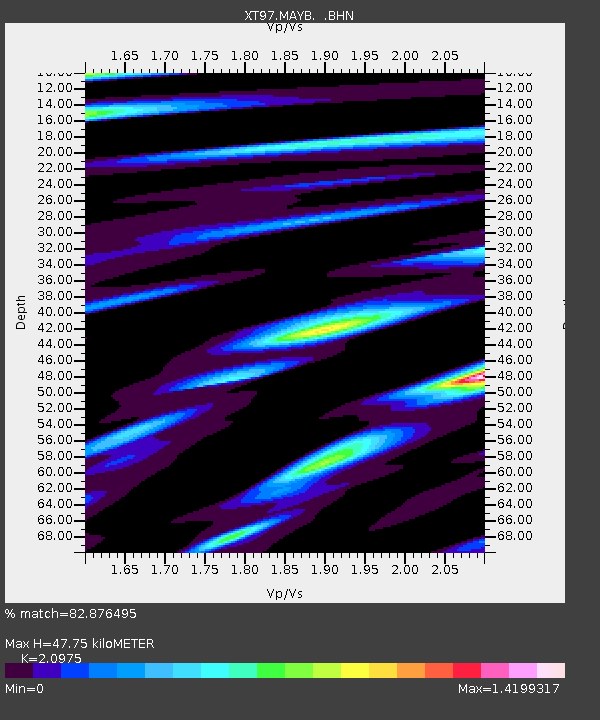
| Estimated Moho Depth: |
47.75 km |
| Estimated Crust Vp/Vs: |
2.10 |
| Assumed Crust Vp: |
6.207 km/s |
| Estimated Crust Vs: |
2.959 km/s |
| Estimated Crust Poisson's Ratio: |
0.35 |
|
| Radial Match: |
82.876495 % |
| Radial Bump: |
400 |
| Transverse Match: |
63.702938 % |
| Transverse Bump: |
400 |
| SOD ConfigId: |
6273 |
| Insert Time: |
2010-03-09 01:40:15.354 +0000 |
| GWidth: |
2.5 |
| Max Bumps: |
400 |
| Tol: |
0.001 |
|

Signal To Noise
| Channel | StoN | STA | LTA |
| XT:MAYB: :BHN:19970910T13:09:20.674011Z | 1.240644 | 1.6305621E-7 | 1.3142869E-7 |
| XT:MAYB: :BHE:19970910T13:09:20.674011Z | 1.1012526 | 2.1815117E-7 | 1.9809367E-7 |
| XT:MAYB: :BHZ:19970910T13:09:20.674011Z | 3.638228 | 3.9070846E-7 | 1.07389766E-7 |
| Arrivals |
| Ps | 8.6 SECOND |
| PpPs | 23 SECOND |
| PsPs/PpSs | 32 SECOND |


