
Station XT MAYB - XT.MAYB
Network: XT97 - Colorado BB Array - Lodore
Nearby stations (2 deg radius)
| Station | Name | (Lat, Lon) | Start / End | Elevation |
| MAYB | XT.MAYB | (40.48, -108.19) | 1997-08-01 / 1998-07-15 | 1888 m |
| Crust2 Type: | Q4,orogen/43km no ice, Tethian Belt, 5 km seds. |
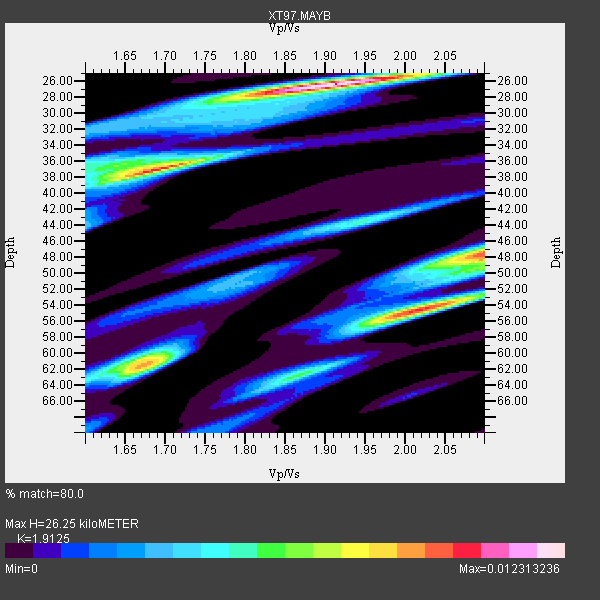
| Thickness Estimate: | 26 km |
| Thickness StdDev: | 13 km |
| Vp/Vs Estimate: | 1.91 |
| Vp/Vs StdDev: | 0.14 |
| Vs Estimate: | 3.245 km/s |
| Poisson's Ratio: | 0.31 |
| Peak Value: | 0.01 |
| Assumed Vp: | 6.207 km/s |
| Ps Weight: | 0.33333334 |
| PpPs Weight: | 0.33333334 |
| PsPs Weight: | 0.33333328 |
| Residual Complexity: | 0.796 |
| Nearby stations H: | +- |
| (2.0 deg) Vp/Vs: | +- |
7 with match > 90% ( 21.875 %) and 17 with match > 80% ( 53.125 %) out of 32.
Download stack as xyz text file.
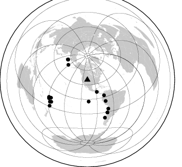
Azimuth Distribution of Events:
Prior Results for this Station
| Study | Thickness | Vp/Vs | Vp | Vs | Poissons Ratio | Extra |
| EARS | 26 km | 1.91 | 6.207 km/s | 3.245 km/s | 0.31 | |
| Crust2.0 | 43 km | 1.76 | 6.207 km/s | 3.535 km/s | 0.26 | Q4,orogen/43km no ice, Tethian Belt, 5 km seds. |
| Global Maxima | 26 km | 1.91 | 6.207 km/s | 3.245 km/s | 0.31 | amp=0.012313236 |
| Local Maxima 1 | 37 km | 1.69 | 6.207 km/s | 3.684 km/s | 0.23 | amp=0.010222639 |
| Local Maxima 2 | 54 km | 2.02 | 6.207 km/s | 3.077 km/s | 0.34 | amp=0.009978579 |
| Local Maxima 3 | 48 km | 2.10 | 6.207 km/s | 2.959 km/s | 0.35 | amp=0.009344214 |
| Local Maxima 4 | 61 km | 1.67 | 6.207 km/s | 3.711 km/s | 0.22 | amp=0.00723212 |
| Predicted Arrivals for vertical incidence (zero ray parameter) | |
| Ps | 3.86 SECOND |
| PpPs | 12.32 SECOND |
| PsPs/PpSs | 16.18 SECOND |
Events Processed for this Station
Download zip of receiver functions as SAC
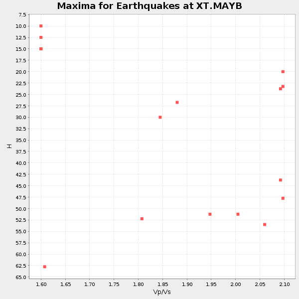
Plot maxima for each earthquake.
Events Used in the Stack
(17 events)| Radial Match | Distance | Baz | FERegion | Time | Lat/Lon | Depth | Magnitude |
| 96.009544 | 83.4 deg | 243.759 deg | Tonga Islands | 1997/08/29 06:54:00 GMT | (-15.2, -175.6) | 33 km | 5.6 MB, 6.4 MS, 6.5 UNKNOWN, 6.4 MW |
| 95.9185 | 57.7 deg | 316.572 deg | Near East Coast Of Kamchatka | 1997/12/07 17:56:18 GMT | (54.7, 162.9) | 33 km | 5.6 MB, 6.0 MS, 6.3 UNKNOWN, 6.1 MW |
| 95.23908 | 78.9 deg | 148.218 deg | Near Coast Of Central Chile | 1997/10/15 01:03:33 GMT | (-30.9, -71.2) | 58 km | 6.8 MB, 6.8 MS, 7.3 UNKNOWN, 7.1 MW |
| 94.39718 | 89.1 deg | 239.707 deg | South Of Fiji Islands | 1997/10/14 09:53:18 GMT | (-22.1, -176.8) | 167 km | 6.7 MB, 7.7 UNKNOWN, 7.4 ME |
| 93.059525 | 44.7 deg | 176.462 deg | Central East Pacific Rise | 1997/08/15 07:37:49 GMT | (-4.4, -105.7) | 10 km | 5.3 MB, 5.8 MS, 6.2 UNKNOWN, 6.1 MW |
| 93.025505 | 87.5 deg | 244.473 deg | Fiji Islands Region | 1998/03/29 19:48:16 GMT | (-17.6, -179.1) | 537 km | 6.5 MB, 7.2 UNKNOWN, 7.1 MW |
| 92.56447 | 78.9 deg | 148.39 deg | Near Coast Of Central Chile | 1998/01/12 10:14:07 GMT | (-31.0, -71.4) | 35 km | 5.8 MB, 6.2 MS, 6.6 UNKNOWN, 6.2 ME |
| 89.81132 | 73.2 deg | 143.953 deg | Near Coast Of Northern Chile | 1998/01/30 12:16:08 GMT | (-23.9, -70.2) | 42 km | 6.3 MB, 6.5 MS, 7.0 UNKNOWN, 6.7 ME |
| 89.80057 | 58.5 deg | 316.139 deg | Off East Coast Of Kamchatka | 1997/12/06 10:59:10 GMT | (54.0, 161.9) | 33 km | 5.7 MB, 5.8 MS, 6.1 UNKNOWN, 6.1 MW |
| 88.76736 | 50.0 deg | 308.194 deg | Rat Islands, Aleutian Islands | 1997/12/17 04:38:51 GMT | (51.2, 178.9) | 20 km | 5.8 MB, 6.5 MS, 6.7 UNKNOWN, 6.1 ME |
| 88.42162 | 86.4 deg | 245.94 deg | Fiji Islands Region | 1998/01/14 17:24:10 GMT | (-15.7, -179.3) | 33 km | 5.8 MB, 6.5 MS, 6.5 UNKNOWN, 6.5 MW |
| 87.295 | 94.2 deg | 235.573 deg | Kermadec Islands Region | 1997/09/20 16:11:32 GMT | (-28.7, -177.6) | 30 km | 6.1 MB, 7.0 MS, 7.2 UNKNOWN, 6.7 ME |
| 86.27658 | 31.5 deg | 141.793 deg | El Salvador | 1997/12/18 15:02:00 GMT | (13.8, -88.7) | 182 km | 5.3 MB, 6.1 UNKNOWN, 6.0 MW |
| 85.63871 | 57.6 deg | 139.104 deg | Peru-Brazil Border Region | 1998/04/03 22:01:48 GMT | (-8.1, -74.2) | 165 km | 6.1 MB, 5.6 MS, 6.6 UNKNOWN, 6.6 MW |
| 84.74857 | 86.0 deg | 155.099 deg | Off Coast Of Southern Chile | 1998/04/01 22:42:56 GMT | (-40.3, -74.9) | 9.0 km | 6.2 MB, 6.0 MS, 6.7 UNKNOWN, 6.6 ME |
| 83.11751 | 46.7 deg | 132.685 deg | Colombia | 1997/09/02 12:13:22 GMT | (3.8, -75.7) | 199 km | 6.5 MB, 6.8 UNKNOWN, 6.4 ME |
| 82.876495 | 87.0 deg | 238.659 deg | Tonga Islands | 1997/09/10 12:57:07 GMT | (-21.3, -174.4) | 10 km | 5.7 MB, 6.1 MS, 6.1 UNKNOWN, 5.9 MW |
Losers
(15 events)| Radial Match | Distance | Baz | FERegion | Time | Lat/Lon | Depth | Magnitude | Reason |
| 74.742935 | 58.7 deg | 316.185 deg | Off East Coast Of Kamchatka | 1997/12/05 11:35:19 GMT | (53.9, 161.6) | 33 km | 5.7 MB | |
| 73.85311 | 95.4 deg | 239.581 deg | South Of Fiji Islands | 1997/09/04 04:23:37 GMT | (-26.6, 178.3) | 625 km | 6.3 MB, 6.8 UNKNOWN, 6.5 ME | |
| 65.98871 | 88.8 deg | 241.286 deg | Fiji Islands Region | 1997/08/25 11:59:00 GMT | (-20.8, -177.8) | 394 km | 5.5 UNKNOWN, 5.3 MB | |
| 62.671516 | 92.1 deg | 242.181 deg | South Of Fiji Islands | 1998/01/27 21:05:44 GMT | (-22.4, 179.0) | 610 km | 5.6 MB, 6.5 UNKNOWN, 6.4 MW | |
| 61.227486 | 89.9 deg | 242.051 deg | Fiji Islands Region | 1997/11/04 10:40:43 GMT | (-21.0, -179.2) | 621 km | 5.7 UNKNOWN, 5.1 MB | |
| 60.80683 | 92.3 deg | 240.468 deg | South Of Fiji Islands | 1998/04/14 03:41:22 GMT | (-23.8, -179.9) | 499 km | 5.5 MB, 6.2 UNKNOWN, 6.1 MW | |
| 59.27202 | 46.6 deg | 132.667 deg | Colombia | 1997/12/11 07:56:28 GMT | (3.9, -75.8) | 178 km | 6.0 MB, 6.4 UNKNOWN, 6.3 MW | |
| 58.779827 | 97.8 deg | 312.239 deg | Southwestern Ryukyu Isl., Japan | 1997/08/13 04:45:04 GMT | (25.0, 125.8) | 55 km | 6.0 MB, 5.6 MS, 6.1 UNKNOWN, 6.1 MW | |
| 58.220226 | 84.3 deg | 309.705 deg | Southeast Of Honshu, Japan | 1998/02/28 17:38:48 GMT | (33.5, 138.1) | 291 km | 5.7 UNKNOWN, 5.3 MB, 5.7 MW | |
| 57.298115 | 63.5 deg | 318.665 deg | Sea Of Okhotsk | 1997/12/20 13:26:31 GMT | (53.4, 152.8) | 614 km | 5.9 UNKNOWN, 5.1 MB, 5.9 MW | |
| 55.51313 | 89.6 deg | 241.916 deg | Fiji Islands Region | 1997/10/17 15:02:00 GMT | (-20.9, -178.8) | 579 km | 5.3 MB, 6.0 UNKNOWN, 6.0 MW | |
| 53.284 | 80.3 deg | 310.621 deg | Near East Coast Of Honshu, Japan | 1998/04/09 08:45:40 GMT | (36.9, 140.8) | 111 km | 5.6 UNKNOWN, 5.3 MB, 5.5 MW | |
| 52.609055 | 76.4 deg | 319.931 deg | Primor'ye, Russia | 1997/10/01 06:05:48 GMT | (46.2, 136.1) | 416 km | 5.5 UNKNOWN, 5.2 MB | |
| 51.461384 | 93.1 deg | 292.182 deg | Mariana Islands | 1997/12/18 20:23:02 GMT | (14.7, 144.7) | 33 km | 5.5 MB, 5.4 MS, 5.9 UNKNOWN, 5.8 MW | |
| 44.719734 | 93.3 deg | 291.648 deg | Mariana Islands | 1998/05/15 05:58:06 GMT | (14.2, 144.9) | 154 km | 5.7 MB, 6.0 UNKNOWN, 6.0 MW |
